Country guide
Greece
40 sacred sites across 9 regions.
Traditions present in Greece
Prominent site types
Aegean
4 sites
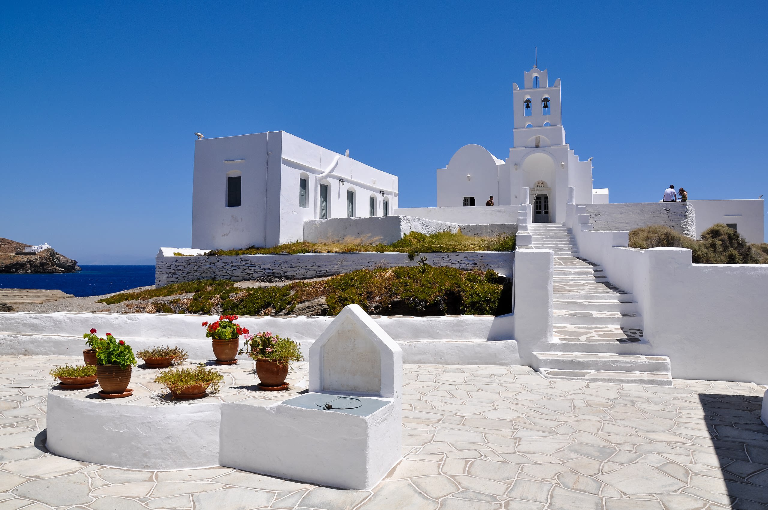
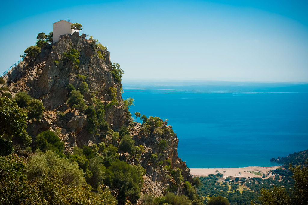
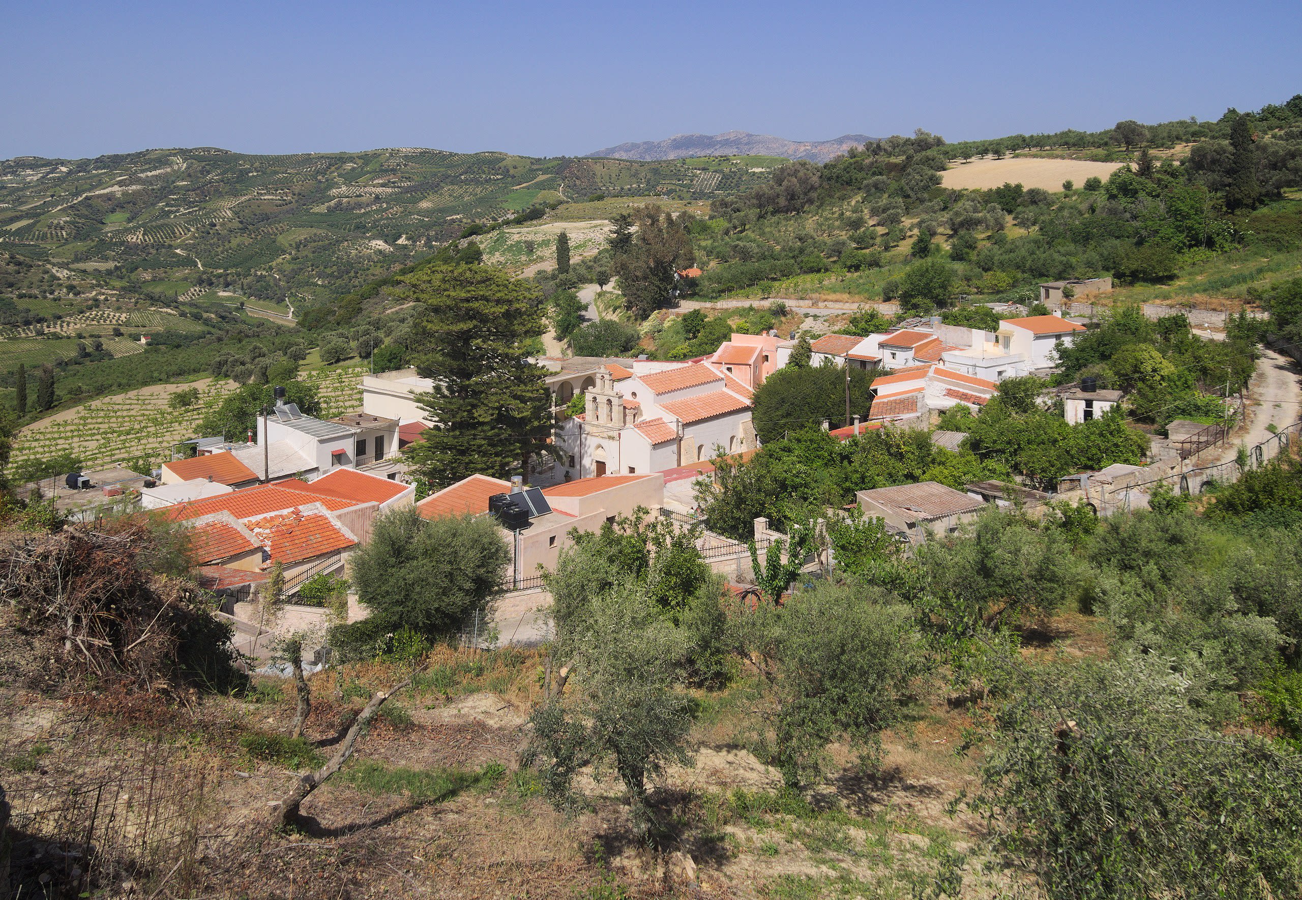
Church of Panagia Chrisopigi, Sifnos Island
Φάρος, Aegean, Greece
Church of Panagia Chrisopigi, Sifnos Island is a church of sacred significance. Approximate coordinates: 36.93641, 24.74631. Attributes: built, cultural. Associated figure: Panagia Chrisopigi.
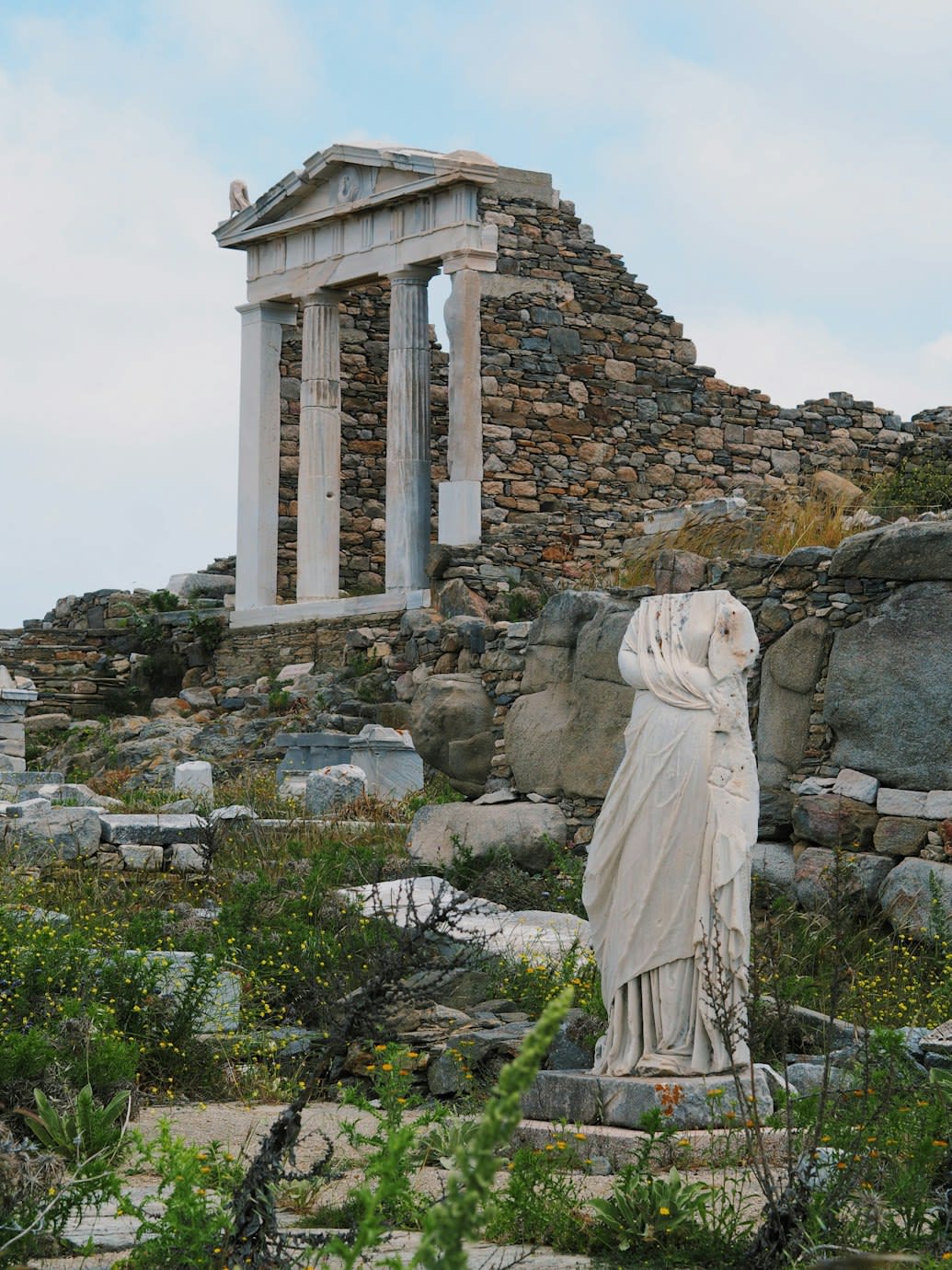
Delos
Municipality of Mykonos, Aegean, Greece
Delos is a mythological and archaeological of sacred significance. Approximate coordinates: 37.40112, 25.26923. Attributes: built, natural, cultural, archaeological, ceremonial. Tradition: Greek Mythology. Associated figure: Apollo, Artemis, Dionysus, Zeus, Athena. Mythological context: Birthplace of Apollo and Artemis. Recognized as a UNESCO World Heritage Site. Delos (; Greek: Δήλος [ˈðilos]; Attic Greek: Δῆλος Dêlos, Doric Greek: Δᾶλος Dâlos), is a small Greek island near Mykonos, close to the centre of the Cyclades archipelago. Though only 3.43 km2 (1.32 sq mi) in area, it is one of the most important mythological, historical, and archaeological sites in Greece. The ongoing excavations in the island are among the most extensive in the Mediterranean, and many of the artifacts found are displayed at the Archaeological Museum of Delos and the National Archaeological Museum of Athens. Delos had a position as a holy sanctuary for a millennium before Olympian Greek mythology made it the birthplace of Apollo and Artemis. From its Sacred Harbour are visible the three conical mounds that have identified landscapes sacred to a goddess (presumably Athena). Another site, retaining its Pre-Greek name Mount Cynthus, is crowned with a sanctuary of Zeus. In 1990, UNESCO added Delos to the World Heritage List, citing its exceptional archaeological site which conveys the image of a great cosmopolitan Mediterranean port , its influence on the development of Greek architecture, and its sacred importance throughout Ancient Greece. Located in Δήμος Μυκόνου, Αποκεντρωμένη Διοίκηση Αιγαίου, Ελλάς.

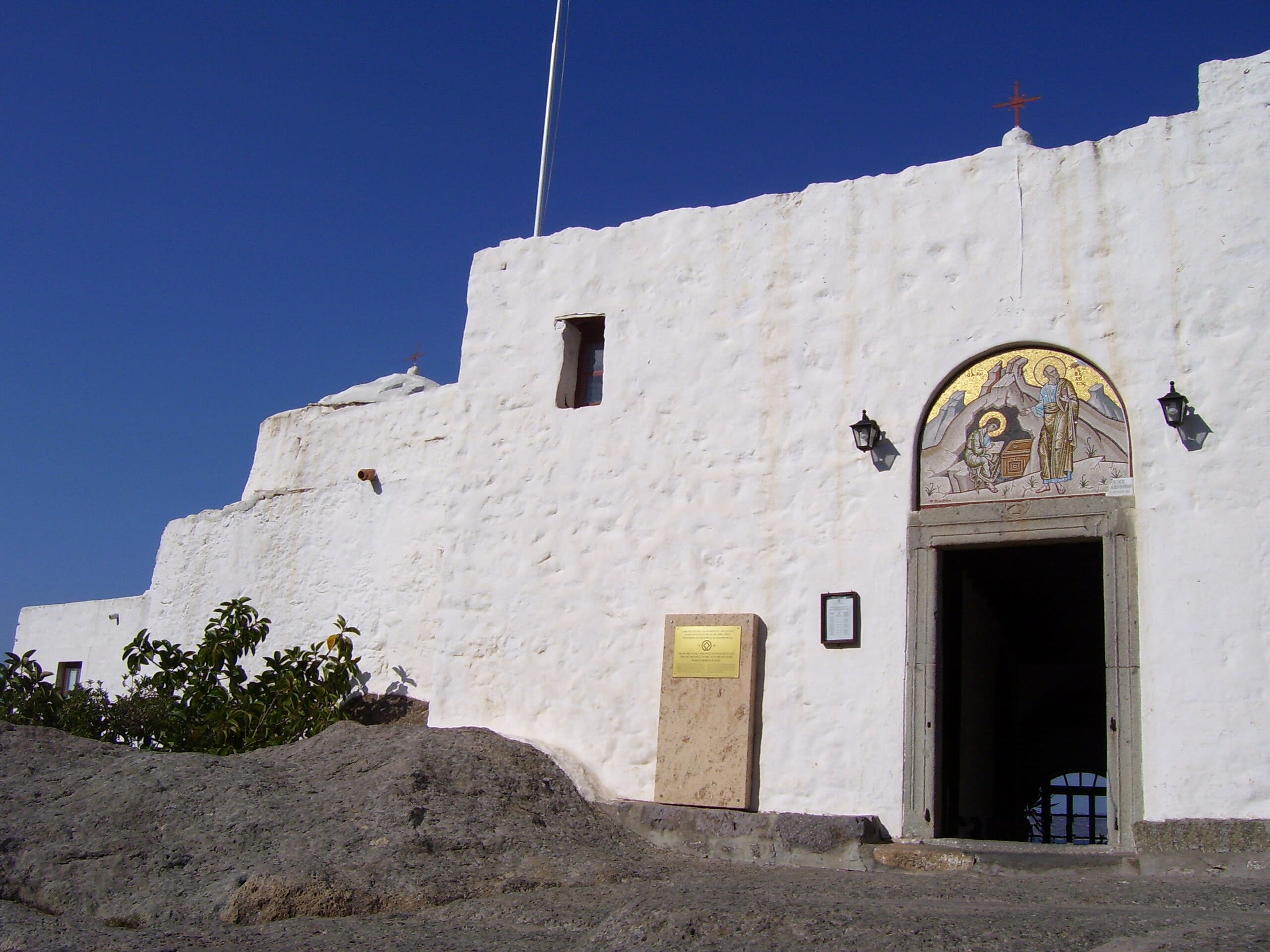
Holy Monastery of Saint John the Theologian, Patmos
Patmos, Aegean, Greece
Patmos is a site of sacred significance. Approximate coordinates: 37.31449, 26.54473. Patmos (Greek: Πάτμος, pronounced [ˈpatmos]) is a Greek island in the Aegean Sea. It is famous as the location where, according to Christian belief, John of Patmos received the vision found in the Book of Revelation of the New Testament, and where the book was written. One of the northernmost islands of the Dodecanese complex, Patmos has a population of 3,283 (2021) and an area of 34.05 km2 (13.15 sq mi). The highest point is Profitis Ilias, 269 metres (883 ft) above sea level. The municipality of Patmos, which includes the offshore islands of Arkoi (pop. 44), Marathos (pop. 5), and several uninhabited islets, has a total population of 3,047 (2011 census) and a combined land area of 45.039 square kilometres (17.390 sq mi). It is part of the Kalymnos regional unit. In 1999, the island s historic center Chora, along with the Monastery of Saint John the Theologian and the Cave of the Apocalypse, were declared World Heritage Sites by UNESCO because of their significance in Christianity and the preservation of ancient religious ceremonies that occur on the island. The monastery was founded by Christodoulos Latrinos. Patmos is also home to the Patmian School, a notable Greek seminary. Located in Δήμος Πάτμου, Αποκεντρωμένη Διοίκηση Αιγαίου, Ελλάς.
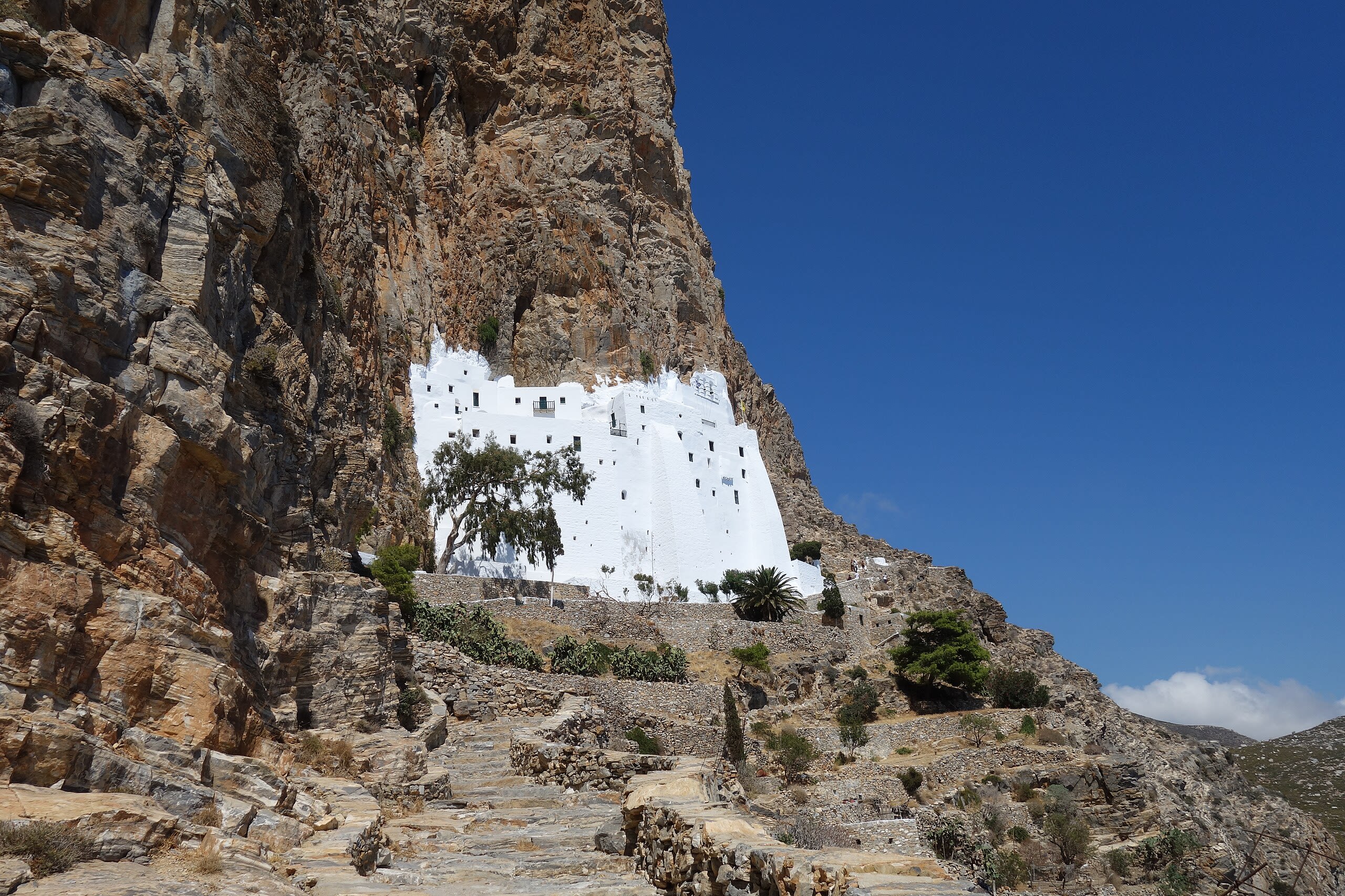
Monastery of Hozoviótissa, Amorgos Island
Amorgos, Aegean, Greece
Monastery of Hozoviótissa, Amorgos Island is a site of sacred significance. Approximate coordinates: 36.83456, 25.90965. Located in Δήμος Αμοργού, Αποκεντρωμένη Διοίκηση Αιγαίου, Ελλάς.
Attica
4 sites

Asklepion shrine
Athens, Attica, Greece
Asklepion shrine is a site of sacred significance. Approximate coordinates: 37.97091, 23.72667. Located in Αθήνα, Αποκεντρωμένη Διοίκηση Αττικής, Ελλάς.
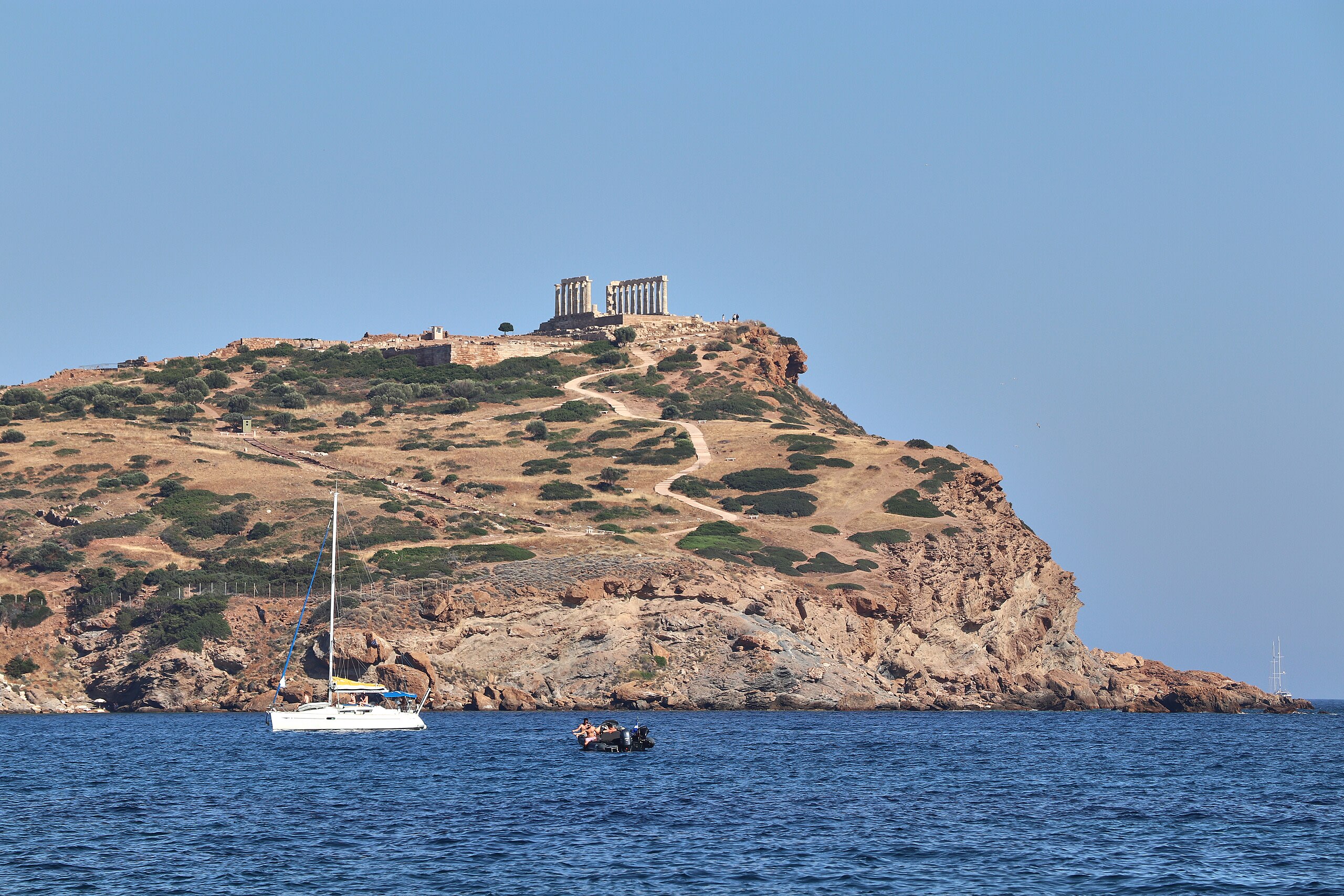
Cape Sounion
Lavreotiki Municipal Unit, Attica, Greece
Cape Sounion is a temple of sacred significance. Approximate coordinates: 37.65016, 24.02458. Attributes: built, cultural, archaeological, pilgrimage. Tradition: Greek. Associated figure: Poseidon. Mythological context: Greek Mythology. Located in Δημοτική Ενότητα Λαυρεωτικής, Αποκεντρωμένη Διοίκηση Αττικής, Ελλάς.

Mount Parnitha
Regional Unit of East Attica, Attica, Greece
Mount Parnitha is a site of sacred significance. Approximate coordinates: 38.17374, 23.71768. Located in Αποκεντρωμένη Διοίκηση Αττικής, Ελλάς.

Parthenon
Athens, Attica, Greece
Parthenon is a site of sacred significance. Approximate coordinates: 37.97154, 23.72672. The Parthenon (; Ancient Greek: Παρθενών, romanized: Parthenōn [par.tʰe.nɔ̌ːn]; Greek: Παρθενώνας, romanized: Parthenónas [parθeˈnonas]) is a former temple on the Athenian Acropolis, Greece, that was dedicated to the goddess Athena. Its decorative sculptures are considered some of the high points of classical Greek art, and the Parthenon is considered an enduring symbol of Ancient Greece, democracy, and Western civilization. The Parthenon was built in the 5th century BC in thanksgiving for the Greek victory over the Persian invaders during the Greco-Persian Wars. Like most Greek temples, the Parthenon also served as the city treasury. Construction started in 447 BC when the Delian League was at the peak of its power. It was completed in 438 BC; work on the artwork and decorations continued until 432 BC. For a time, it served as the treasury of the Delian League, which later became the Athenian Empire. In the final decade of the 6th century AD, the Parthenon was converted into a Christian church dedicated to the Virgin Mary. After the Ottoman conquest in the mid-15th century, it became a mosque. In the Morean War, a Venetian bomb landed on the Parthenon, which the Ottomans had used as a munitions dump, during the 1687 siege of the Acropolis. The resulting explosion severely damaged the Parthenon. From 1800 to 1803, the 7th Earl of Elgin controversially removed many of the surviving sculptures and subsequently shipped them to England where they are now known as the Elgin Marbles or Parthenon marbles. Since 1975, numerous large-scale restoration projects have been undertaken to preserve remaining artefacts and ensure its structural integrity. Located in Αθήνα, Αποκεντρωμένη Διοίκηση Αττικής, Ελλάς.
Autonomous Monastic State of the Holy Mountain
1 sites
Epirus and Western Macedonia
1 sites
Macedonia and Thrace
3 sites
Kutuklu Baba Tekke, Selina, Greece
Συδινή, Macedonia and Thrace, Greece
Kutuklu Baba Tekke, Selina, Greece is a tekke of sacred significance. Approximate coordinates: 41.07561, 25.05824. Attributes: built, cultural, pilgrimage. Tradition: Bektashi Order. Associated figure: Kutuklu Baba. Located in Δήμος Αβδήρων, Αποκεντρωμένη Διοίκηση Μακεδονίας - Θράκης, Ελλάς.

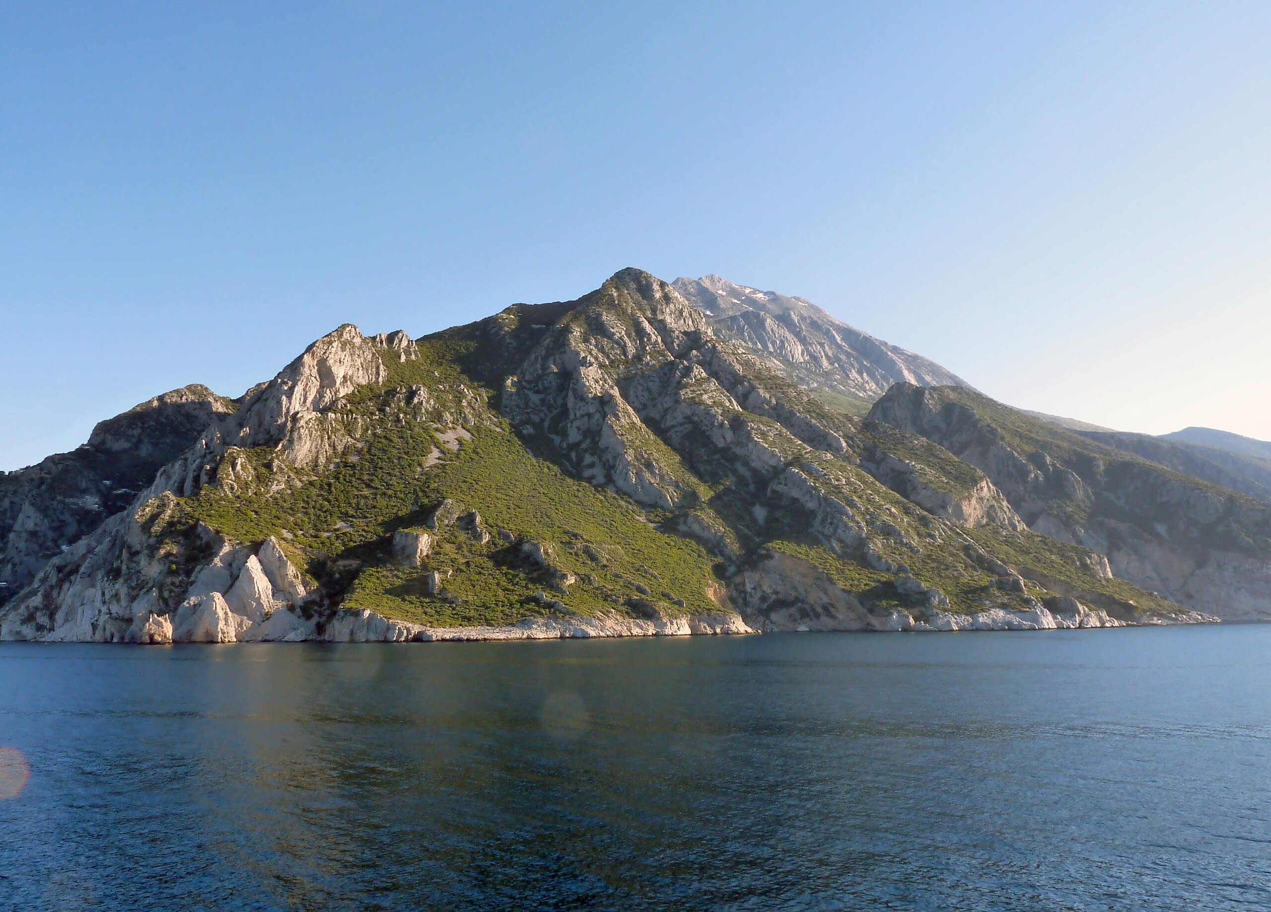
Mt. Olympus
Dion - Olympos Municipality, Macedonia and Thrace, Greece
Mt. Olympus is a site of sacred significance. Approximate coordinates: 40.08841, 22.35856. Located in Δήμος Δίου - Ολύμπου, Αποκεντρωμένη Διοίκηση Μακεδονίας - Θράκης, Ελλάς.
Panagia Krimniotissa
Municipality of Samothraki, Macedonia and Thrace, Greece
Panagia Krimniotissa is a site of sacred significance. Approximate coordinates: 40.40541, 25.58584. Located in Δήμος Σαμοθράκης, Αποκεντρωμένη Διοίκηση Μακεδονίας - Θράκης, Ελλάς.
Patmos
1 sites
Peloponnese, Western Greece and the Ionian
4 sites
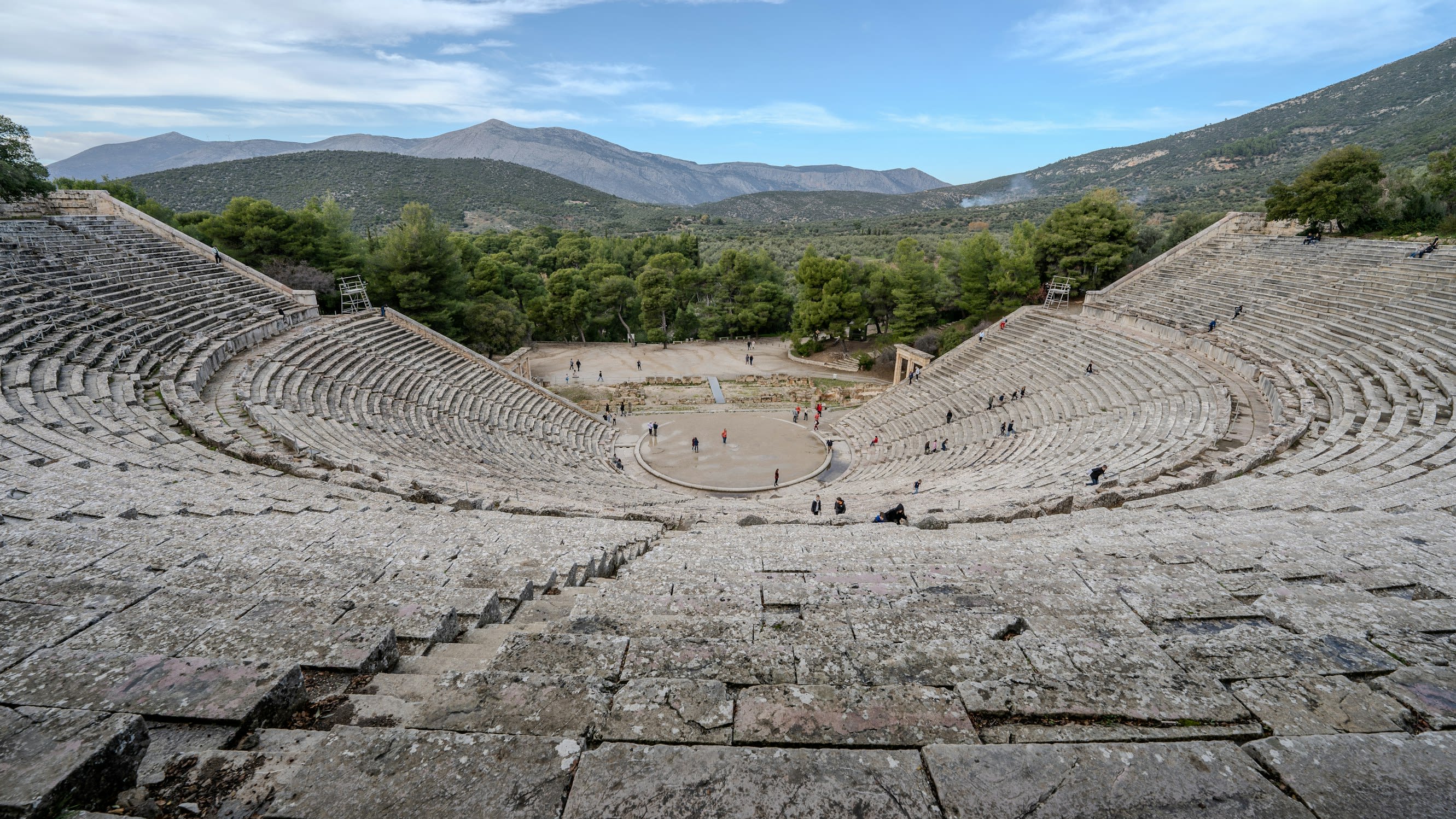
Epidauros
Municipal Unit of Epidavros, Peloponnese, Western Greece and the Ionian, Greece
Epidauros is a sanctuary of sacred significance. Approximate coordinates: 37.63345, 23.16023. Attributes: built, cultural, archaeological, pilgrimage, ceremonial. Tradition: Ancient Greek. Associated figure: Apollo Maleatas. Mythological context: Greek Mythology. Recognized as a UNESCO World Heritage Site. Located in Δημοτική Ενότητα Επιδαύρου, Αποκεντρωμένη Διοίκηση Πελοποννήσου, Δυτικής Ελλάδας και Ιονίου, Ελλάς.

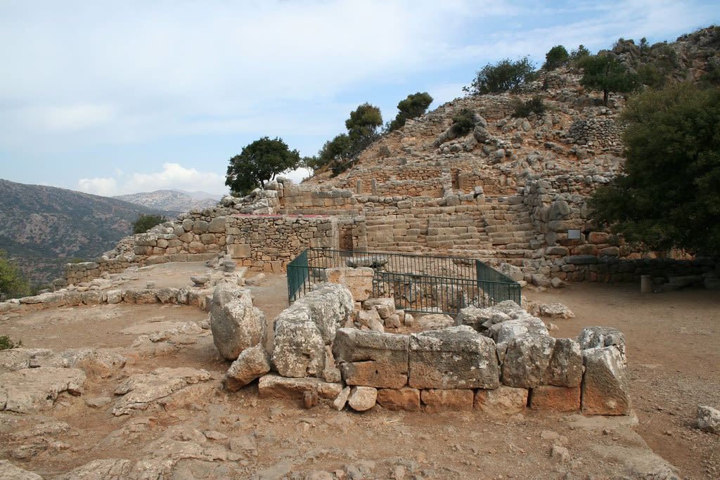
Mycenae
Municipal Unit of Mykines, Peloponnese, Western Greece and the Ionian, Greece
Mycenae is a site of sacred significance. Approximate coordinates: 37.73086, 22.75613. Mycenae ( my-SEE-nee; Mycenaean Greek: 𐀘𐀏𐀙𐀂; Ancient Greek: Μυκῆναι or Μυκήνη, Mykē̂nai or Mykḗnē) is an archaeological site near Mykines in Argolis, north-eastern Peloponnese, Greece. It is located about 120 kilometres (75 miles) south-west of Athens; 11 kilometres (7 miles) north of Argos; and 48 kilometres (30 miles) south of Corinth. The site is 19 kilometres (12 miles) inland from the Saronic Gulf and built upon a hill rising 900 feet (274 metres) above sea level. In the second millennium BC, Mycenae was one of the major centres of Greek civilisation, a military stronghold which dominated much of southern Greece, Crete, the Cyclades and parts of southwest Anatolia. The period of Greek history from about 1600 BC to about 1100 BC is called Mycenaean in reference to Mycenae. At its peak in 1350 BC, the citadel and lower town had a population of 30,000 and an area of 32 hectares (79 acres). The first correct identification of Mycenae in modern literature was in 1700, during a survey conducted by the Venetian engineer Francesco Vandeyk on behalf of Francesco Grimani, the Provveditore Generale of the Kingdom of the Morea. Vandeyk used Pausanias s description of the Lion Gate to identify the ruins of Mycenae. In 1999 the archeological site of Mycenae was added to the UNESCO World Heritage List, along with the nearby site of Tiryns, because of its historical importance as the center of the Mycenaean civilization, its outstanding architecture and its testimony to the development of Ancient Greek civilization. The Lion Gate, the Treasury of Atreus and the walls of Mycenae and Tiryns are examples of the noteworthy architecture found in Mycenae and Tiryns. The structures and layouts of these discoveries exemplify the creative talent of the time. Greek architecture and urban planning have been significantly influenced by the Mycenaean civilization. Mycenae and Tiryns, which stand as the pinnacle of the early phases of Greek civilisation, provided unique witness to political, social and economic growth during the Mycenaean civilization. The accomplishments of the Mycenaean civilisation in art, architecture and technology, which inspired European cultures, are also on display at both locations. These sites are strongly connected to the Homeric epics. The earliest examples of the Greek language are also visible at Mycenae and Tiryn, preserved on Linear B tablets. A stringent legal framework was established to safeguard the integrity of the Mycenae and Tiryns sites against vandalism and other forms of damage and disturbance to the remains. The Hellenic Ministry of Culture and Sports monitors the two archaeological sites. To maintain the quality and conditions of the Mycenaean and Tiryn sites, archaeological study is conducted methodically and systematically. The Greek Antiquities Law No 3028/2002, on the ‘Conservation of Antiquities and Cultural Heritage in General’, governs the preservation and protection of the sites. Ministerial Decree No 2160 of 1964 created and safeguarded the limits of Mycenae in addition to the sites themselves. The acropolis and the wider surroundings are also covered by the extension of protection conferred by this ministerial decree. Ministerial Decrees No 102098/4753 of 1956 and 12613/696 of 1991 both provide protection for the Tiryns archaeological site. Located in Δημοτική Ενότητα Μυκηναίων, Αποκεντρωμένη Διοίκηση Πελοποννήσου, Δυτικής Ελλάδας και Ιονίου, Ελλάς.

Olympia
Municipal Unit of Archea Olympia, Peloponnese, Western Greece and the Ionian, Greece
Olympia is a site of sacred significance. Approximate coordinates: 37.63798, 21.63033. Olympia may refer to: Located in Δημοτική Ενότητα Αρχαίας Ολυμπίας, Αποκεντρωμένη Διοίκηση Πελοποννήσου, Δυτικής Ελλάδας και Ιονίου, Ελλάς.

Oracle at Cape Tainaron (Mataram), Peloponnese, Greece
East Mani Municipal Unit, Peloponnese, Western Greece and the Ionian, Greece
Oracle at Cape Tainaron (Mataram), Peloponnese, Greece is a site of sacred significance. Approximate coordinates: 36.38638, 22.48291. Located in Δημοτική Ενότητα Ανατολικής Μάνης, Αποκεντρωμένη Διοίκηση Πελοποννήσου, Δυτικής Ελλάδας και Ιονίου, Ελλάς.
Region of Crete
18 sites

Agia Triada Monastery
Chania, Region of Crete, Greece
Agia Triada Monastery is a monastery of sacred significance. Approximate coordinates: 35.56057, 24.13502. Attributes: built, cultural. Tradition: Greek Orthodox. Associated figure: Holy Trinity. Agia Triada Monastery ((in Greek) Μονή Αγίας Τριάδος) or the Monastery of Agia Triada Tsangarolon is a Greek Orthodox monastery in the Akrotiri peninsula in the Chania regional unit, Crete, Greece. It also contains a museum. The monastery, whose name means Holy Trinity , was built in the 17th century by two brothers of the Venetian Zangaroli family on the site of a pre-existing church. The monks produce and sell wine and olive oil on the premises. Located in Χανιά, Αποκεντρωμένη Διοίκηση Κρήτης, Ελλάς.
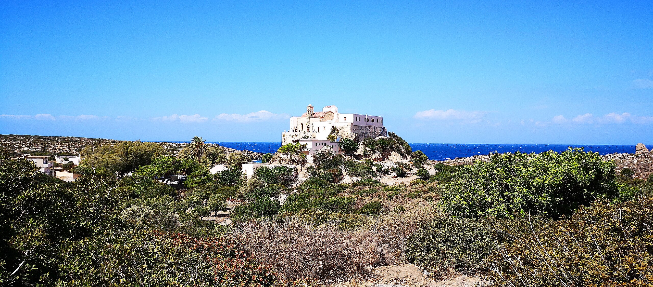
Chrysoskalitissa Monastery
Chrisoskalitissa, Region of Crete, Greece
Chrysoskalitissa Monastery is a monastery of sacred significance. Approximate coordinates: 35.31125, 23.53327. Attributes: built, cultural. Tradition: Eastern Orthodox Christian. Chrysoskalitissa Monastery (Greek: Μονή Χρυσοσκαλιτίσσης) is a 17th-century Eastern Orthodox Christian monastery located on the southwest coast of the island of Crete, Greece. Within the municipal district of Innachori of the municipality of Kissamos, the monastery lies about 72 kilometres southwest of Chania. Built up on rocks 35 metres above the water, it overlooks the Libyan Sea. Located in Δήμος Κισσάμου, Αποκεντρωμένη Διοίκηση Κρήτης, Ελλάς.
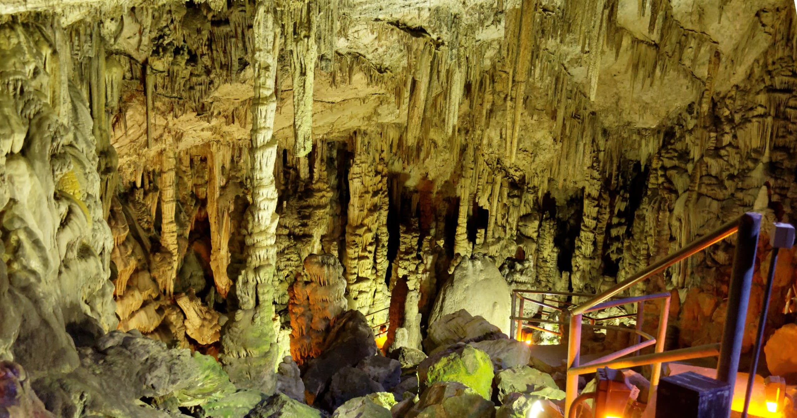
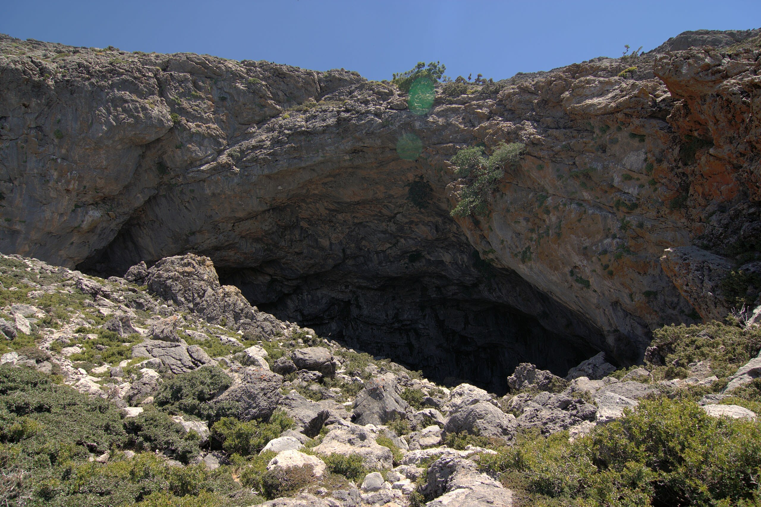
Diktaion Andron Cave
Psichro, Region of Crete, Greece
Diktaion Andron Cave is a cave of sacred significance. Approximate coordinates: 35.16262, 25.44525. Attributes: natural, cultural, archaeological, pilgrimage, ceremonial. Tradition: Greek Mythology. Associated figure: Zeus. Mythological context: Birthplace of Zeus. Located in Δήμος Οροπεδίου Λασιθίου, Αποκεντρωμένη Διοίκηση Κρήτης, Ελλάς.
Kamares Cave
Tybakio Municipal Unit, Region of Crete, Greece
Kamares Cave is a cave of sacred significance. Approximate coordinates: 35.17749, 24.82762. Attributes: natural, cultural, archaeological. Located in Δημοτική Ενότητα Τυμπακίου, Αποκεντρωμένη Διοίκηση Κρήτης, Ελλάς.
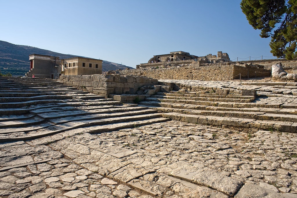
Knossos
Heraklion Municipal Unit, Region of Crete, Greece
Knossos is a archaeological site of sacred significance. Approximate coordinates: 35.29796, 25.16312. Attributes: built, cultural, archaeological, ceremonial. Tradition: Minoan. Mythological context: Greek Mythology. Knossos (; Ancient Greek: Κνωσσός, romanized: Knōssós, pronounced [knɔː.sós]; Linear B: 𐀒𐀜𐀰 Ko-no-so) is a Bronze Age archaeological site in Crete. The site was a major centre of the Minoan civilization and is known for its association with the Greek myth of Theseus and the minotaur. It is located on the outskirts of Heraklion, and remains a popular tourist destination. Knossos is considered by many to be the oldest city in Europe. Knossos is dominated by the monumental Palace of Minos. Like other Minoan palaces, this complex of buildings served as a combination religious and administrative centre rather than a royal residence. The earliest parts of the palace were built around 1900 BC in an area that had been used for ritual feasting since the Neolithic. The palace was continually renovated and expanded over the next five centuries until its final destruction around 1350 BC. The site was first excavated by Minos Kalokairinos in 1877. In 1900, Sir Arthur Evans undertook more extensive excavations which unearthed most of the palace as well as many now-famous artifacts including the Bull-Leaping Fresco, the snake goddess figurines, and numerous Linear B tablets. While Evans is often credited for discovering the Minoan Civilization, his work is controversial in particular for his inaccurate and irreversible reconstructions of architectural remains at the site. Located in Δημοτική Ενότητα Ηρακλείου, Αποκεντρωμένη Διοίκηση Κρήτης, Ελλάς.
Lato
Agios Nikolaos Municipal Unit, Region of Crete, Greece
Lato is a ancient city of sacred significance. Approximate coordinates: 35.17904, 25.65529. Attributes: built, cultural, archaeological. Tradition: Ancient Greek. Lato (Ancient Greek: Λατώ, romanized: Latṓ) was an ancient city of Crete, the ruins of which are located approximately 3 km from the village of Kritsa. Located in Δημοτική Ενότητα Αγίου Νικολάου, Αποκεντρωμένη Διοίκηση Κρήτης, Ελλάς.

Monastery of Arkadi
Municipality of Rethymnon, Region of Crete, Greece
Monastery of Arkadi is a site of sacred significance. Approximate coordinates: 35.31006, 24.62899. Located in Δήμος Ρεθύμνης, Αποκεντρωμένη Διοίκηση Κρήτης, Ελλάς.

Mt. Dicti
Psichro, Region of Crete, Greece
Mt. Dicti is a site of sacred significance. Approximate coordinates: 35.16262, 25.44524. Located in Δήμος Οροπεδίου Λασιθίου, Αποκεντρωμένη Διοίκηση Κρήτης, Ελλάς.

Mt. Ida
Kouroutes, Region of Crete, Greece
Mt. Ida is a site of sacred significance. Approximate coordinates: 35.22641, 24.77072. Located in Δήμος Μυλοποτάμου, Αποκεντρωμένη Διοίκηση Κρήτης, Ελλάς.

Mt. Juktas Minoan Peak Sanctuary, Crete
Archanes Municipal Unit, Region of Crete, Greece
Mt. Juktas Minoan Peak Sanctuary, Crete is a site of sacred significance. Approximate coordinates: 35.23993, 25.14416. Located in Δημοτική Ενότητα Αρχανών, Αποκεντρωμένη Διοίκηση Κρήτης, Ελλάς.

Mt. Kofinas Minoan Peak Sanctuary, Crete
Kofinas Municipal Unit, Region of Crete, Greece
Mt. Kofinas Minoan Peak Sanctuary, Crete is a site of sacred significance. Approximate coordinates: 34.96167, 25.07938. Located in Δημοτική Ενότητα Κόφινα, Αποκεντρωμένη Διοίκηση Κρήτης, Ελλάς.
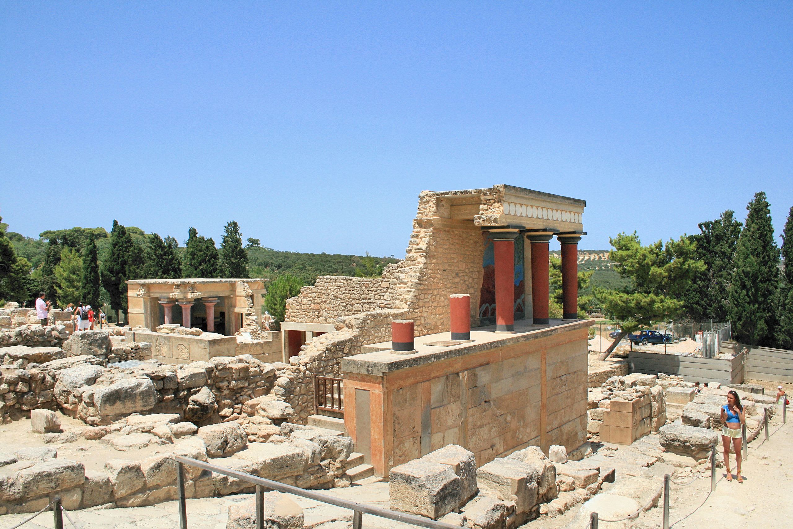
Palace of Knossos
Heraklion Municipal Unit, Region of Crete, Greece
Palace of Knossos is a site of sacred significance. Approximate coordinates: 35.29782, 25.16313. Located in Δημοτική Ενότητα Ηρακλείου, Αποκεντρωμένη Διοίκηση Κρήτης, Ελλάς.
Paliani Monastery
Paliani Municipal Unit, Region of Crete, Greece
Paliani Monastery is a site of sacred significance. Approximate coordinates: 35.19083, 25.04242. Located in Δημοτική Ενότητα Παλιανής, Αποκεντρωμένη Διοίκηση Κρήτης, Ελλάς.

Panagia Kera
Agios Nikolaos Municipal Unit, Region of Crete, Greece
Panagia Kera is a site of sacred significance. Approximate coordinates: 35.15677, 25.65520. Located in Δημοτική Ενότητα Αγίου Νικολάου, Αποκεντρωμένη Διοίκηση Κρήτης, Ελλάς.
Petsofas Minoan Peak Sanctuary
Itanos Municipal Unit, Region of Crete, Greece
Petsofas Minoan Peak Sanctuary is a site of sacred significance. Approximate coordinates: 35.18333, 26.30000. Located in Δημοτική Ενότητα Ιτάνου, Αποκεντρωμένη Διοίκηση Κρήτης, Ελλάς.
Pyrgos Minoan Temple
Ierapetra Municipal Unit, Region of Crete, Greece
Pyrgos Minoan Temple is a site of sacred significance. Approximate coordinates: 35.00688, 25.59070. Located in Δημοτική Ενότητα Ιεράπετρας, Αποκεντρωμένη Διοίκηση Κρήτης, Ελλάς.

Traostalos Minoan Peak Sanctuary
Itanos Municipal Unit, Region of Crete, Greece
Traostalos Minoan Peak Sanctuary is a site of sacred significance. Approximate coordinates: 35.12660, 26.26701. Located in Δημοτική Ενότητα Ιτάνου, Αποκεντρωμένη Διοίκηση Κρήτης, Ελλάς.

Tylissos Minoan Temple
Tylissos Municipal Unit, Region of Crete, Greece
Tylissos Minoan Temple is a site of sacred significance. Approximate coordinates: 35.29834, 25.02024. Located in Δημοτική Ενότητα Τυλίσου, Αποκεντρωμένη Διοίκηση Κρήτης, Ελλάς.
Thessaly and Central Greece
4 sites
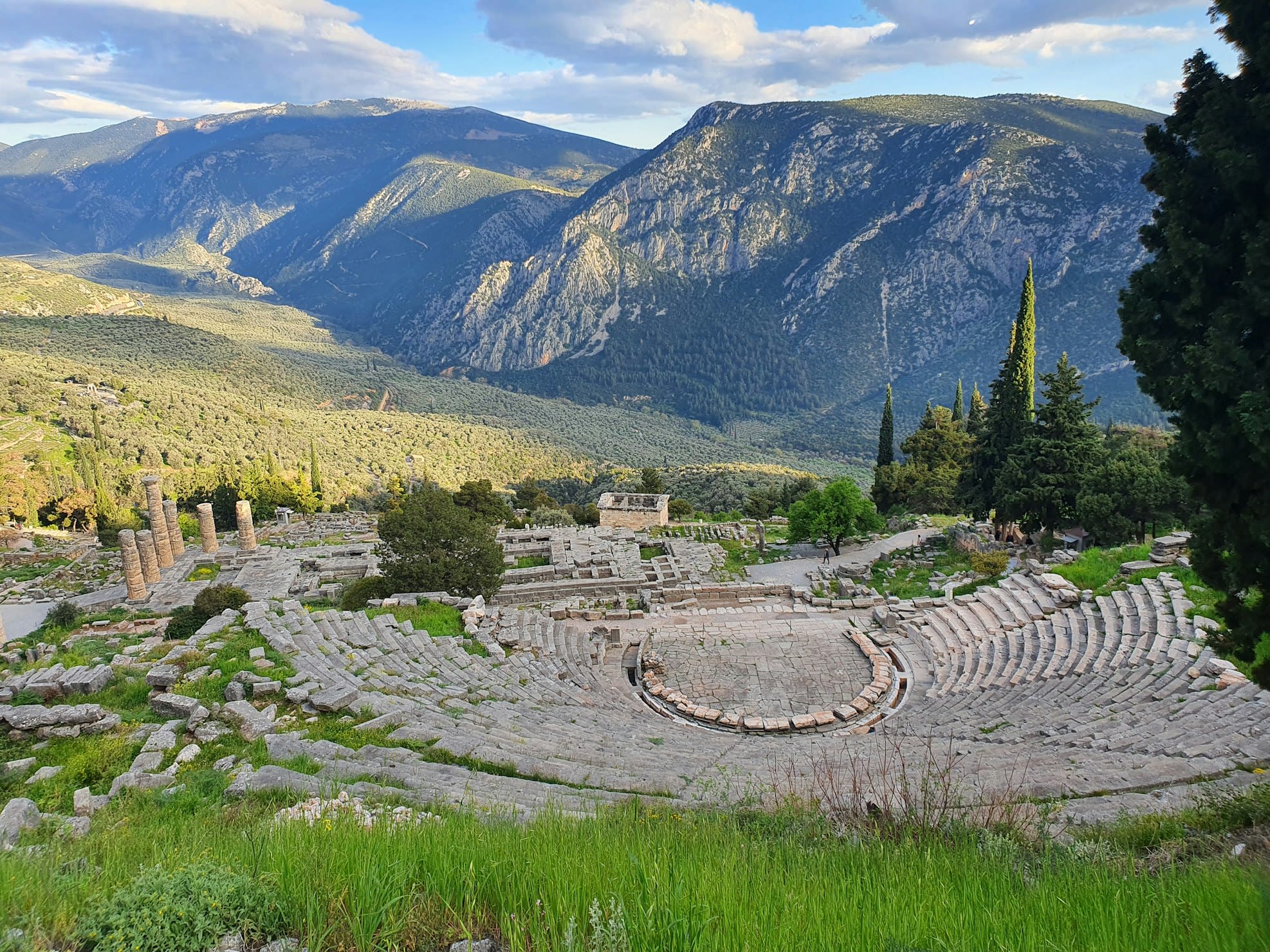
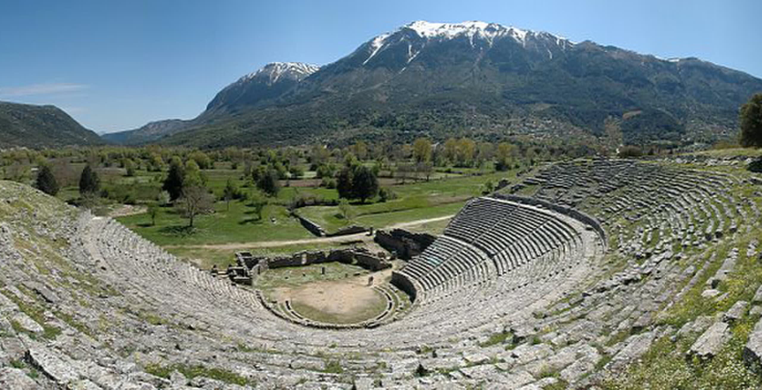
Delphi
Municipal Unit of Delphi, Thessaly and Central Greece, Greece
Delphi is a ancient sacred precinct of sacred significance. Approximate coordinates: 38.48235, 22.50123. Attributes: built, natural, cultural, archaeological, pilgrimage, ceremonial. Tradition: Ancient Greek. Associated figure: Apollo. Mythological context: Greek Mythology. Recognized as a UNESCO World Heritage Site. Delphi (; Greek: Δελφοί [ðelˈfi]), in legend previously called Pytho (Πυθώ), was an ancient sacred precinct and the seat of Pythia, the major oracle who was consulted about important decisions throughout the ancient classical world. The ancient Greeks considered the centre of the world to be in Delphi, marked by the stone monument known as the Omphalos of Delphi (navel). According to the Suda, Delphi took its name from the Delphyne, the she-serpent (drakaina) who lived there and was killed by the god Apollo (in other accounts the serpent was the male serpent (drakon) Python). The sacred precinct occupies a delineated region on the south-western slope of Mount Parnassus. It is now an extensive archaeological site, and since 1938 a part of Parnassos National Park. The precinct is recognized by UNESCO as a World Heritage Site in having had a great influence in the ancient world, as evidenced by the various monuments built there by most of the important ancient Greek city-states, demonstrating their fundamental Hellenic unity. Adjacent to the sacred precinct is a small modern town of the same name. Located in Δημοτική Ενότητα Δελφών, Αποκεντρωμένη Διοίκηση Θεσσαλίας - Στερεάς Ελλάδος, Ελλάς.

Meteora
Kalabaka, Thessaly and Central Greece, Greece
Meteora is a site of sacred significance. Approximate coordinates: 39.72139, 21.63363. The Meteora (; Greek: Μετέωρα, pronounced [meˈteora]) is a rock formation in the regional unit of Trikala, in Thessaly, in northwestern Greece, hosting one of the most prominent complexes of Eastern Orthodox monasteries, viewed locally as second in importance only to Mount Athos. Twenty-four monasteries were established atop the giant natural pillars and hill-like rounded boulders that dominate the local area, mainly from the second half of the 14th century under the local rule of Simeon Uroš.: 414-415 Six of these are still active and open to visitors: the monasteries of Great Meteoron (est. 1356), Varlaam, Saint Nicholas Anapausas, Rousanou, Holy Trinity, and Saint Stephen. The latter became a community of nuns in 1961, whereas the former five remain managed by monks. Meteora is located in between the town of Kalabaka and the village of Kastraki at the northwestern edge of the Plain of Thessaly near the Pineios river and Pindus Mountains. The Meteora complex was added to the UNESCO World Heritage List in 1988 because of its outstanding architecture and beauty, combined with religious and cultural significance. The name means lofty , elevated , and is etymologically related to meteor. Located in Δήμος Μετεώρων, Αποκεντρωμένη Διοίκηση Θεσσαλίας - Στερεάς Ελλάδος, Ελλάς.

Mt. Pelion
Municipal Unit of Zagora, Thessaly and Central Greece, Greece
Mt. Pelion is a site of sacred significance. Approximate coordinates: 39.43833, 23.04750. Located in Δημοτική Ενότητα Ζαγοράς, Αποκεντρωμένη Διοίκηση Θεσσαλίας - Στερεάς Ελλάδος, Ελλάς.

Trofonion Oracle, Livadia, Greece
Levadia Municipal Unit, Thessaly and Central Greece, Greece
Trofonion Oracle, Livadia, Greece is a site of sacred significance. Approximate coordinates: 38.43150, 22.87501. Located in Δημοτική Ενότητα Λεβαδέων, Αποκεντρωμένη Διοίκηση Θεσσαλίας - Στερεάς Ελλάδος, Ελλάς.