Site type guide
Town
Crawlable taxonomy page generated from the current site detail schema and used in the internal linking graph.
Countries to explore next
Traditions represented here
9 sites
Browse this type across countries, traditions, and sacred landscapes.

Belogradchik
Belogradchik, Vidin, Bulgaria
Belogradchik is a town of sacred significance. Approximate coordinates: 43.62321, 22.67795. Attributes: built, natural, cultural. Belogradchik (Bulgarian: Белоградчик, lit. Small White Town ; pronounced [bɛɫoɡrɐtˈt͡ʃik]) is a town in Vidin Province, northwestern Bulgaria, and is the administrative centre of the homonymous municipality. The town is situated in the foothills of the Balkan Mountains just east of the Serbian border and about 50 km south of the Danube River. The town is close to the Belogradchik Rocks, which are major tourist attraction. As of 2024, it had a population of 4,601. Located in Видин, Bulgaria.

Chachoengsao
Chachoengsao, Chachoengsao Province, Thailand
Chachoengsao is a town of sacred significance. Approximate coordinates: 13.67376, 101.06718. Attributes: built, cultural. Tradition: Buddhism. Chachoengsao (Thai: ฉะเชิงเทรา, pronounced [t͡ɕʰàʔ.t͡ɕʰɤ̄ːŋ.sāw]) is a town (thesaban mueang) in central Thailand, capital of Chachoengsao Province. It is on the banks of the Bang Pakong River. It includes tambon Na Mueang and parts of Ban Mai, Bang Tin Pet, Wang Takhian, and Sothon of Mueang Chachoengsao District. In 2006, it had a population of 60,893. The town was established in 1549 during the reign of King Maha Chakkrapat of Ayutthaya and originally was a centre for military recruitment. During the reign of King Maha Thammaracha, the kingdom was in a weak condition due to being defeated by the Burmese. Phraya Lawaek, the Khmer king, conscripted Thais from several towns including Chachoengsao to be in his work force. Chachoengsao is sometimes referred to as Paet Riu , a name derived from large fish locally caught in the past. Paet Riu literally means eight cuts or slices which refers to the way the fish was cooked and served as a local dish in Chachoengsao. The town is about 50 km east of Bangkok and can be accessed by train. Located in Mueang Chachoengsao, ประเทศไทย.

Chichicastenango
Chichicastenango, Quiché, Guatemala
Chichicastenango is a town of sacred significance. Approximate coordinates: 14.94212, -91.11139. Attributes: built, cultural. Tradition: Mayan Kiche. Associated figure: Santo Tomas. Chichicastenango, also known as Santo Tomás Chichicastenango, is a town, with a population of 71,394 (2018 census), and the municipal seat for the surrounding municipality of the same name in the El Quiché department of Guatemala. It is located in a mountainous region about 140 km (87 mi) northwest of Guatemala City, at an altitude of 1,965 m (6,447 ft). The Spanish conquistadors gave the town its name from the Nahuatl name used by their allied soldiers from Tlaxcala: Tzitzicaztenanco, or City of Nettles. Its original name was Chaviar. Chichicastenango is a K iche Maya cultural centre. According to the 2012 census, 98.5% of the municipality s population is indigenous Mayan K iche. Of the population, 21% speak only K iche, 71% speak both K iche and Spanish, and the remaining 8% speak only Spanish. Located in Quiché, Guatemala.

Downpatrick
Downpatrick, Northern Ireland, United Kingdom
Downpatrick is a town of sacred significance. Approximate coordinates: 54.32382, -5.67662. Attributes: built, cultural, pilgrimage. Tradition: Christianity. Associated figure: St. Patrick. Downpatrick (from Irish Dún Pádraig, meaning Patrick s fort ) is a town in County Down, Northern Ireland. It is on the Lecale peninsula, about 21 mi (34 km) south of Belfast. In the Middle Ages, it was the capital of the Dál Fiatach, the main ruling dynasty of Ulaid. Its cathedral is said to be the burial place of Saint Patrick. Today, it is the county town of Down and the joint headquarters of Newry, Mourne and Down District Council. Downpatrick had a population of 11,545 according to the 2021 Census. Located in Northern Ireland / Tuaisceart Éireann, United Kingdom.

Glastonbury
Glastonbury, England, United Kingdom
Glastonbury is a town of sacred significance. Approximate coordinates: 51.14473, -2.69869. Attributes: built, cultural, archaeological, pilgrimage. Tradition: Christianity. Associated figure: St John the Baptist. Mythological context: Christian and Arthurian legends. Glastonbury ( GLAST-ən-bər-ee, UK also GLAHST-) is a town and civil parish in Somerset, England, situated at a dry point on the low-lying Somerset Levels, 23 miles (37 km) south of Bristol. The town had a population of 8,932 in the 2011 census. Glastonbury is less than 1 mile (2 km) across the River Brue from Street, which is now larger than Glastonbury. Evidence from timber trackways such as the Sweet Track show that the town has been inhabited since Neolithic times. Glastonbury Lake Village was an Iron Age village, close to the old course of the River Brue and Sharpham Park approximately 2 miles (3 km) west of Glastonbury, that dates back to the Bronze Age. Centwine was the first Saxon patron of Glastonbury Abbey, which dominated the town for the next 700 years. One of the most important abbeys in England, it was the site of Edmund Ironside s coronation as King of England in 1016. Many of the oldest surviving buildings in the town, including the Tribunal, George Hotel and Pilgrims Inn and the Somerset Rural Life Museum, which is based at the site of a 14th-century abbey manor barn, often referred to as a tithe barn, are associated with the abbey. The Church of St John the Baptist dates from the 15th century. The town became a centre for commerce, which led to the construction of the market cross, Glastonbury Canal and the Glastonbury and Street railway station, the largest station on the original Somerset and Dorset Railway. The Brue Valley Living Landscape is a conservation project managed by the Somerset Wildlife Trust and nearby is the Ham Wall National Nature Reserve. Glastonbury has been described as having a New Age community, and possibly being where New Age beliefs originated at the turn of the twentieth century. It is notable for myths and legends often related to Glastonbury Tor, concerning Joseph of Arimathea, the Holy Grail and King Arthur. Joseph is said to have arrived in Glastonbury and stuck his staff into the ground, when it flowered miraculously into the Glastonbury Thorn. The presence of a landscape zodiac around the town has been suggested but no evidence has been discovered. The Glastonbury Festival, held in the nearby village of Pilton, takes its name from the town. Located in England, United Kingdom.
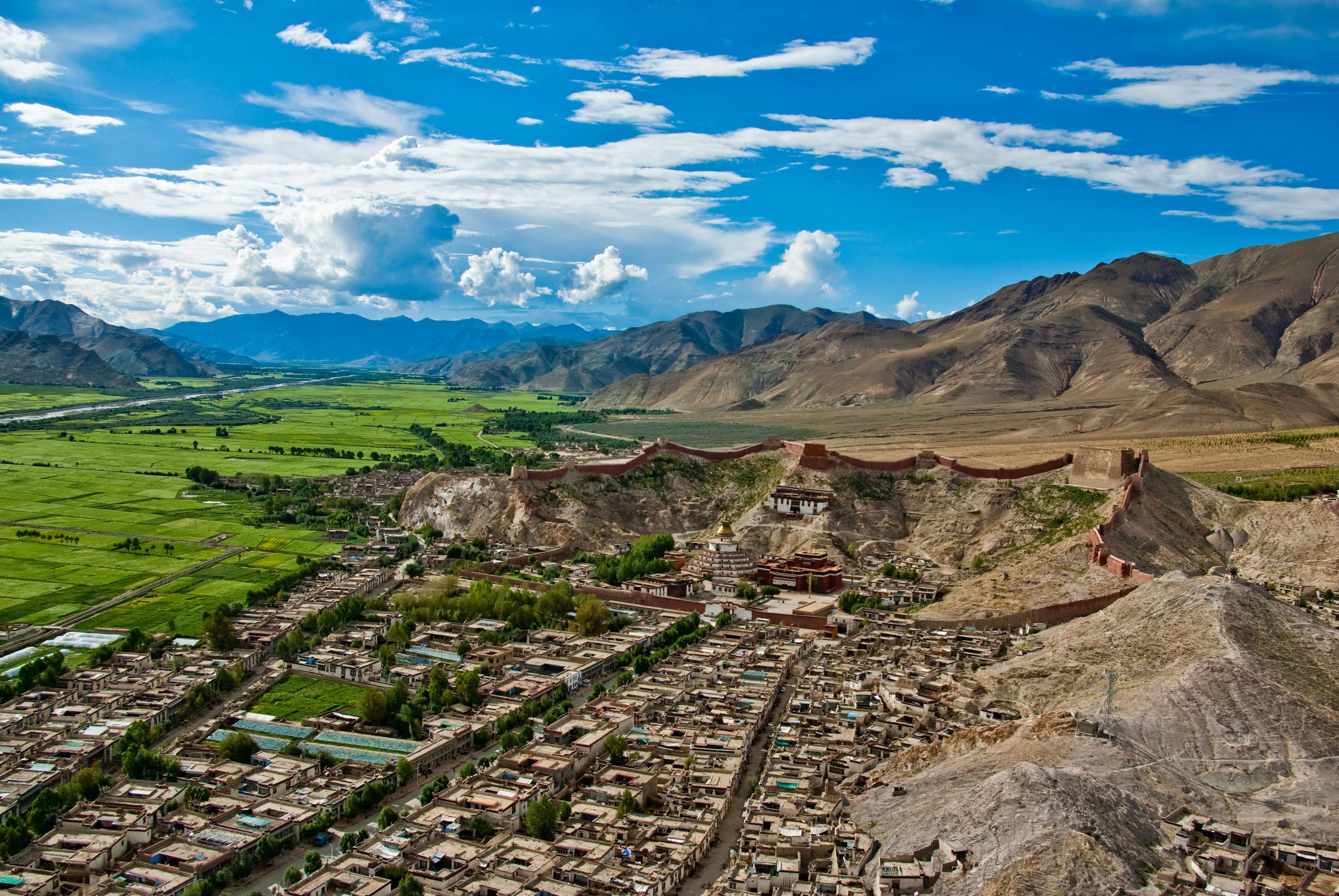
Gyantse
Gyantse County, Tibet, China
Gyantse is a town of sacred significance. Approximate coordinates: 28.92358, 89.60329. Attributes: built, cultural. Tradition: Buddhism. Gyantse, officially Gyangzê Town (also spelled Gyangtse; Tibetan: རྒྱལ་རྩེ, Wylie: rgyal rtse, ZYPY: Gyangzê; simplified Chinese: 江孜镇; traditional Chinese: 江孜鎮; pinyin: Jiāngzī Zhèn), is a town located in Gyantse County, Shigatse Prefecture, Tibet Autonomous Region, China. It was historically considered the third largest and most prominent town in Tibet (after Lhasa and Shigatse), but there are now at least ten larger Tibetan cities. Located in 江孜县 རྒྱལ་རྩེ་རྫོང།, 西藏自治区 བོད་རང་སྐྱོང་ལྗོངས།, China.
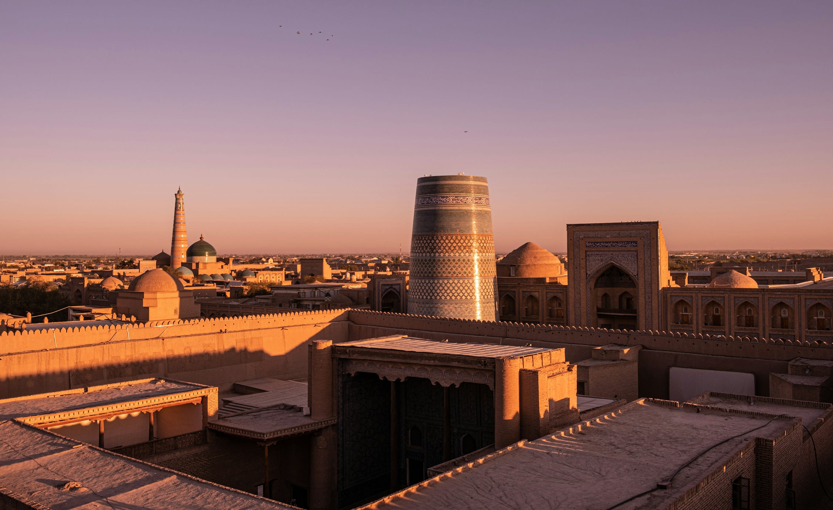
Itchan Kala
Khiva, Xorazm Region, Uzbekistan
Itchan Kala is a historic town of sacred significance. Approximate coordinates: 41.37775, 60.35977. Attributes: built, cultural. Tradition: Islamic. Recognized as a UNESCO World Heritage Site. Itchan Kala (Uzbek: Ichan-Qаl’а) is the walled inner town of the city of Khiva, Uzbekistan. Since 1990, it has been protected as a World Heritage Site. The old town retains more than 50 historic monuments and 250 old houses, dating primarily from the eighteenth or nineteenth centuries. Juma Mosque, for instance, was established in the tenth century and rebuilt from 1788 to 1789, although its celebrated hypostyle hall still retains 112 columns taken from ancient structures. Notable buildings in Itchan Kala are Konya Ark, Juma Mosque, Ak Mosque, Hasanmurod Qushbegi mosque, madrasahs of Alla-Kulli-Khan, Muhammad Aminkhon, Muhammad Rakhimkhon, Mausoleums of Pahlavon Mahmoud, Sayid Allavuddin, Shergozikhon as well as caravanserais and markets. Located in Xorazm Viloyati, Oʻzbekiston.

Kanchanaburi
Phra Thaen, Kanchanaburi Province, Thailand
Kanchanaburi is a town municipality of sacred significance. Approximate coordinates: 14.03376, 99.78880. Attributes: built, cultural. Kanchanaburi (Thai: กาญจนบุรี, pronounced [kāːn.t͡ɕā.ná(ʔ).bū.rīː]) is a town municipality (thesaban mueang) in Kanchanaburi Province, Thailand. The town of lies to the southeast of Erawan National Park within Kanchanaburi Province, approximately 120km west of Bangkok. In 2006 it had a population of 31,327. That number was reduced to 25,651 in 2017. The town covers tambons Ban Nuea and Ban Tai and parts of Pak Phraek and Tha Makham, all of Mueang Kanchanaburi District, and parts of tambon Tha Lo of Tha Muang District. Located in พระแท่น, Tha Maka, ประเทศไทย.

Lamphun
Lamphun, Lamphun Province, Thailand
Lamphun is a town of sacred significance. Approximate coordinates: 18.57731, 99.00791. Attributes: built, cultural, pilgrimage. Tradition: Buddhism. Lamphun (Northern Thai: ᩃᨻᩪᩁ; Thai: ลำพูน, pronounced [lām.pʰūːn]) is a town (thesaban mueang) in northern Thailand, capital of Lamphun Province. It covers the whole tambon Nai Mueang of Mueang Lamphun district. As of 2006 it has a population of 14,030. Lamphun lies 665 km (413 mi) north of Bangkok and 19 km (12 mi) south of Chiang Mai. Located in เวียงยอง, Mueang Lamphun, ประเทศไทย.