Guatemala
Chiquimula
1 site

Esquipulas
Esquipulas (Nahuatl: Isquitzuchil, "place where flowers abound"), officially Municipality of Esquipulas, whose original name was Yzquipulas, is a town, with a population of 18,667 (2018 census), and a municipality located in the department of Chiquimula, in eastern Guatemala. Esquipulas' main attraction is the beautiful Black Christ located in the Basilica of Esquipulas, making the town an important place of Catholic pilgrimage for Central America. It is also one of the most important towns of the country and one that has had the most economic and cultural growth. In 2002, it was registered on UNESCO's tentative World Heritage list. The city is a tourist attraction due to its ecological and religious importance. It is the most visited city and town across eastern Guatemala and the second most visited in the country, surpassed only by the City of Guatemala, visited annually by approximately four to five million tourists and devout Catholics, this due to its important and varied religious resorts and distributed in the 495 km2, the smallest city visited by Pope John Paul II in 1996 which entitled him recognition as Capital Central to the Faith, whose recognition is currently known as to this city, which was also visited by Teresa of Calcutta, hosted the Esquipulas Peace Accords during the mid-1980s. The Basilica of Esquipulas headquarters in Central Catholic Faith is the first wonder of Guatemala competition held by the Industrial Bank on November 26, 2008. In 1987 the Trifinio Biosphere Reserve was created to protect the unique flora and fauna in the region. The territory comprises an area of 495 km2, distributed in 20 villages, 123 sub villages, one town and two villas which are Timushán and Chanmagua, with a total population of 53,556 (2018 census); with the town of Esquipulas having a population of 18,667 which represents 35% of the total population of the municipality. Esquipulas is located 222 kilometers from Guatemala City, 9.5 kilometers from the border with the Republic of Honduras and 45 kilometers from the city of Chiquimula, bordering the municipalities of Olopa, Jocotán and the department Camotán Chiquimula to the north and the municipality of Metapan, El Salvador to the south. To the east it meets the departments of Copán and Ocotepeque, Honduras and to the west, the municipality of Concepción Las Minas and the Resume Chiquimula department.
Escuintla
2 sites

El Baul
El Baul is a maya site of sacred significance. Approximate coordinates: 14.33658, -91.00010. Attributes: built, cultural, archaeological. Tradition: Maya. Located in Escuintla, Guatemala.

Monte Alto
Monte Alto may refer to:
Guatemala Department
1 site

Kaminaljuyu
Kaminaljuyu (pronounced ; from Kʼicheʼʼ, "The Hill of the Dead") is a Pre-Columbian site of the Maya civilization located in Guatemala City. Primarily occupied from 1500 BC to 1200 AD, it has been described as one of the greatest archaeological sites in the New World—although the extant remains are distinctly unimpressive. Debate continues about its size, integration, and role in the surrounding Valley of Guatemala and the Southern Maya area. Kaminaljuyu, when first mapped scientifically, comprised some 200 platforms and pyramidal mounds. The site was largely swallowed up by real estate developments. A portion of the Classic Period center is preserved as a 0.5 square km park—a fraction of the original ruins field size of around 5 square km.
Huehuetenango
1 site

Chiantla
Chiantla (Spanish pronunciation: [ˈtʃjantla]) is a town and municipality in the Guatemalan department of Huehuetenango. The municipality is situated at 2,000 metres above sea level and covers an area of 521 km2. The annual festival is on January 28.
Izabal
1 site

Quirigua
Quirigua is a site of sacred significance. Approximate coordinates: 15.27044, -89.03955. Located in Izabal, Guatemala.
Petén
7 sites

Altar de Sacrificios
Altar de Sacrificios is a ceremonial center and archaeological site of the pre-Columbian Maya civilization, situated near the confluence of the Pasión and Salinas Rivers (where they combine to form the Usumacinta River), in the present-day department of Petén, Guatemala. Along with Seibal and Dos Pilas, Altar de Sacrificios is one of the better-known and most intensively-excavated sites in the region, although the site itself does not seem to have been a major political force in the Late Classic period.
El Ceibal
El Ceibal is a maya site of sacred significance. Approximate coordinates: 16.53616, -90.07690. Attributes: built, cultural, archaeological. Tradition: Maya. Located in Sayaxché, Petén, Guatemala.

El Mirador
El Mirador (which translates as "the lookout", "the viewpoint", or "the belvedere") is a large pre-Columbian Middle and Late Preclassic (1000 BC – 250 AD) Maya settlement, located in the north of the modern department of El Petén, Guatemala. It is part of the Mirador-Calakmul Karst Basin of northern Guatemala.
Piedras Negras
Piedras Negras is a site of sacred significance. Approximate coordinates: 17.17868, -91.25647. Located in Petén, Guatemala.
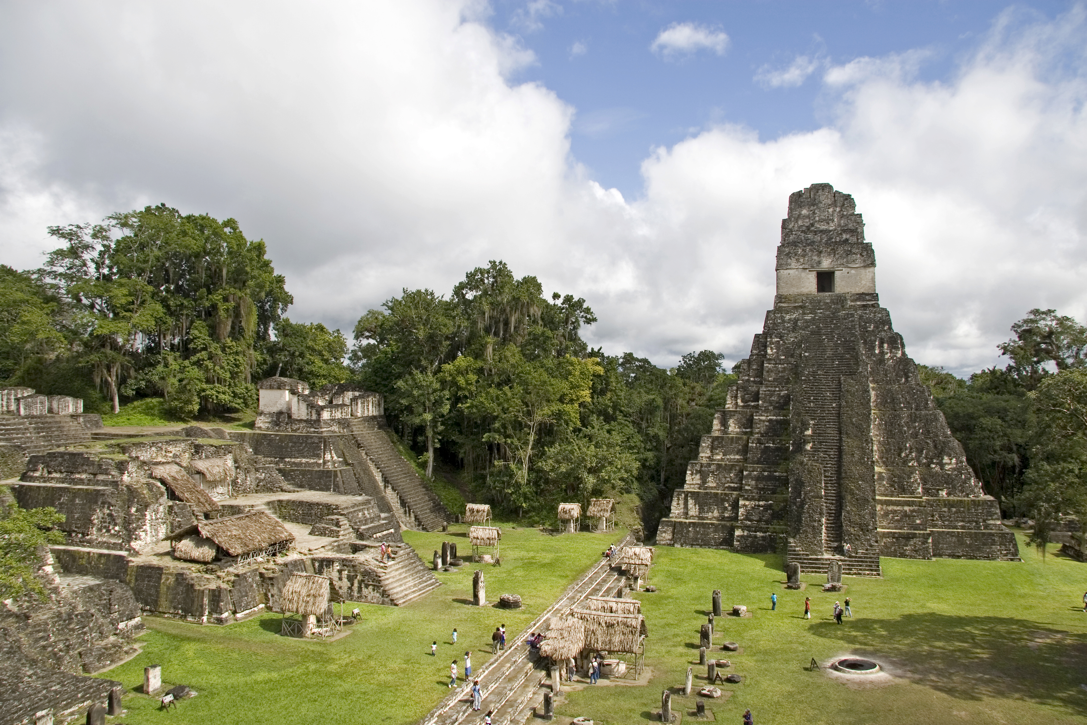
Tikal
Tikal is a site of sacred significance. Approximate coordinates: 17.21385, -89.62217. Located in Flores, Petén, Guatemala.

Uaxactun
Uaxactun (pronounced [waʃakˈtun]) is an ancient sacred place of the Maya civilization, located in the Petén Basin region of the Maya lowlands, in the present-day department of Petén, Guatemala. The site lies some 12 miles (19 km) north of the major center of Tikal. The name is sometimes spelled as Waxaktun.

Yaxha
Yaxha (or Yaxhá in Spanish orthography) is a Mesoamerican archaeological site in the northeast of the Petén Basin in modern-day Guatemala. As a ceremonial centre of the pre-Columbian Maya civilization, Yaxha was the third largest city in the region and experienced its maximum power during the Early Classic period (c. AD 250–600). The city was located on a ridge overlooking Lake Yaxha. The name of the city derives from the Mayan for "blue-green water"; it is a notable survival of a Classic period place-name into the modern day. The Yaxha kingdom is estimated to have covered an area of 237 square kilometres (92 sq mi) and to have had a peak population of 42,000 in the Late Classic period of Mesoamerican chronology. Yaxha had a long history of occupation with the first settlement being founded sometime in the Middle Preclassic period (c. 1000–350 BC). It developed into the largest city in the eastern Petén lakes region during the Late Preclassic (c. 350 BC – AD 250) and expanded into an enormous city during the Early Classic (c. AD 250–600). At this time, in common with other sites in Petén, it shows strong influence from the distant metropolis of Teotihuacan in the Valley of Mexico. It was eclipsed during the Late Classic (c. AD 600–900) by neighbouring Naranjo but was never completely dominated. The city survived well into the Terminal Classic (c. 800–900) but was abandoned by the Postclassic period (c. 900–1525). The ruins of the city were first reported by Teoberto Maler who visited them in 1904. The site was mapped in the 1930s and again in the 1970s and stabilisation work began in the late 1980s. The ruins include the remains of more than 500 structures with a number of major archaeological groups linked by causeways. Approximately 40 Maya stelae have been discovered at the site, about half of which feature sculpture.
Quiché
1 site

Chichicastenango
Chichicastenango, also known as Santo Tomás Chichicastenango, is a town, with a population of 71,394 (2018 census), and the municipal seat for the surrounding municipality of the same name in the El Quiché department of Guatemala. It is located in a mountainous region about 140 km (87 mi) northwest of Guatemala City, at an altitude of 1,965 m (6,447 ft). The Spanish conquistadors gave the town its name from the Nahuatl name used by their allied soldiers from Tlaxcala: Tzitzicaztenanco, or City of Nettles. Its original name was Chaviar. Chichicastenango is a K'iche' Maya cultural centre. According to the 2012 census, 98.5% of the municipality's population is indigenous Mayan K'iche. Of the population, 21% speak only K'iche, 71% speak both K'iche and Spanish, and the remaining 8% speak only Spanish.
Retalhuleu
1 site

Abaj Takalik
Abaj Takalik is a archaeological site of sacred significance. Approximate coordinates: 14.64604, -91.73567. Attributes: built, cultural, archaeological. Tradition: Maya.
Sacatepéquez
1 site

Church of Entombed Christ of San Felipe
Church of Entombed Christ of San Felipe is a church of sacred significance. Approximate coordinates: 14.57317, -90.73468. Attributes: built, cultural. Associated figure: Christ. Located in Antigua Guatemala, Sacatepéquez, Guatemala.
San Marcos
1 site
Ciudad Tecun Uman
Ciudad Tecun Uman is a church of sacred significance. Approximate coordinates: 14.67876, -92.14051. Attributes: built, cultural. Located in San Marcos, Guatemala.