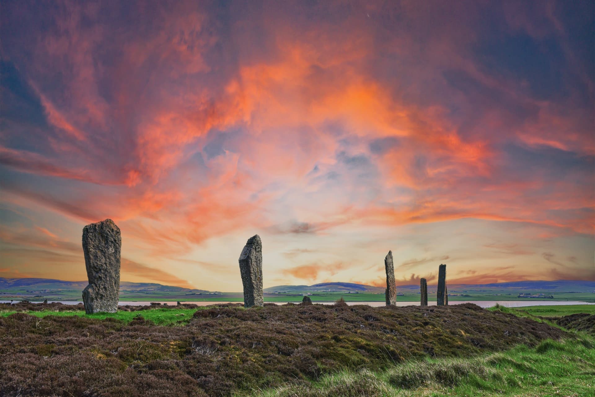
Standing Stones of Stenness
Where Neolithic Orkney raised the oldest henge in Britain between salt water and fresh, stone and sky
Stenness, Orkney Islands, United Kingdom
At A Glance
- Coordinates
- 58.9941, -3.2077
- Suggested Duration
- 1-2 hours including Barnhouse Settlement
Pilgrim Tips
- Dress for Orkney weather. Waterproofs and warm layers essential. Wind is near-constant and can be strong. Sturdy footwear recommended.
- Photography permitted. The thin profiles of the stones photograph dramatically in low light. Dawn and dusk offer the strongest contrasts.
- Orkney weather is changeable and often windy. Dress in layers with waterproofs. The site is exposed with no shelter. No toilets at the stones; nearest facilities at Maeshowe Visitor Centre. The small car park has a one-way system.
Overview
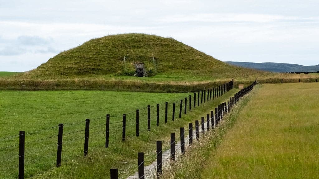
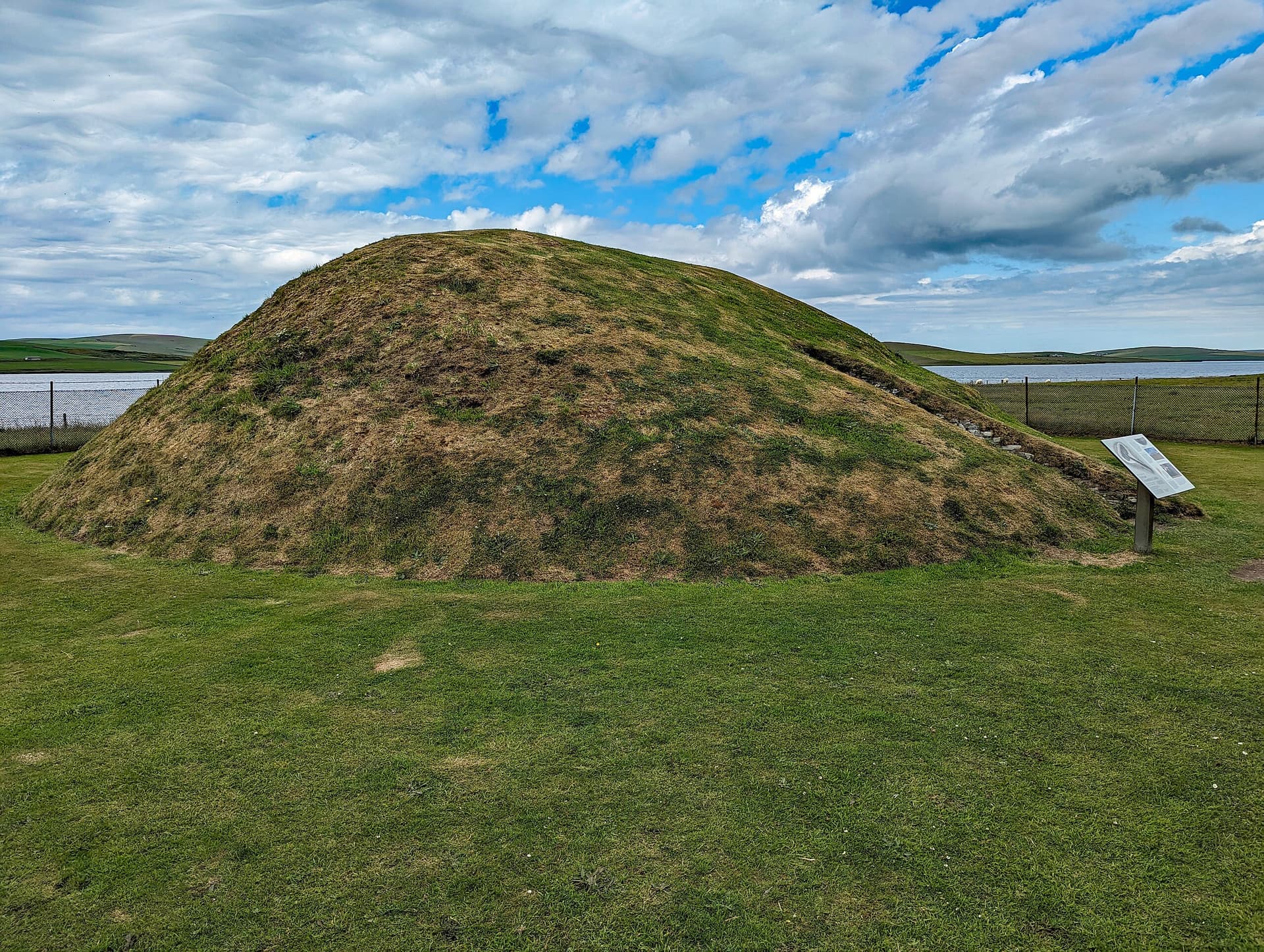
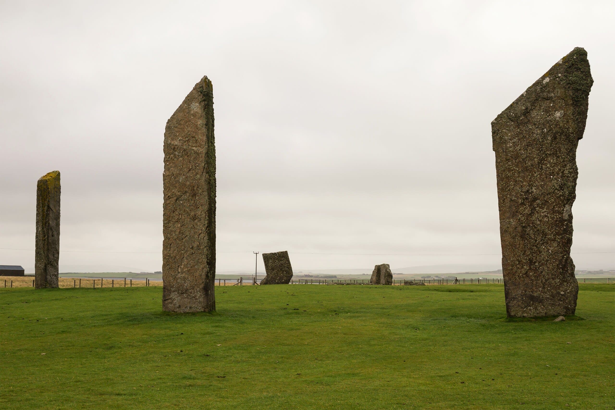
On the narrow isthmus between the salt Loch of Stenness and the freshwater Loch of Harray, four surviving megaliths stand where perhaps twelve once formed an ellipse. Raised around 3100 BC, these thin stone slabs reaching nearly six metres into the Orkney sky may mark the oldest henge monument in the British Isles. A central hearth still holds the ash of Neolithic fires. The entrance faces the Barnhouse Settlement, connecting the domestic world to the ceremonial one across a threshold that people crossed five thousand years ago. They cross it still.
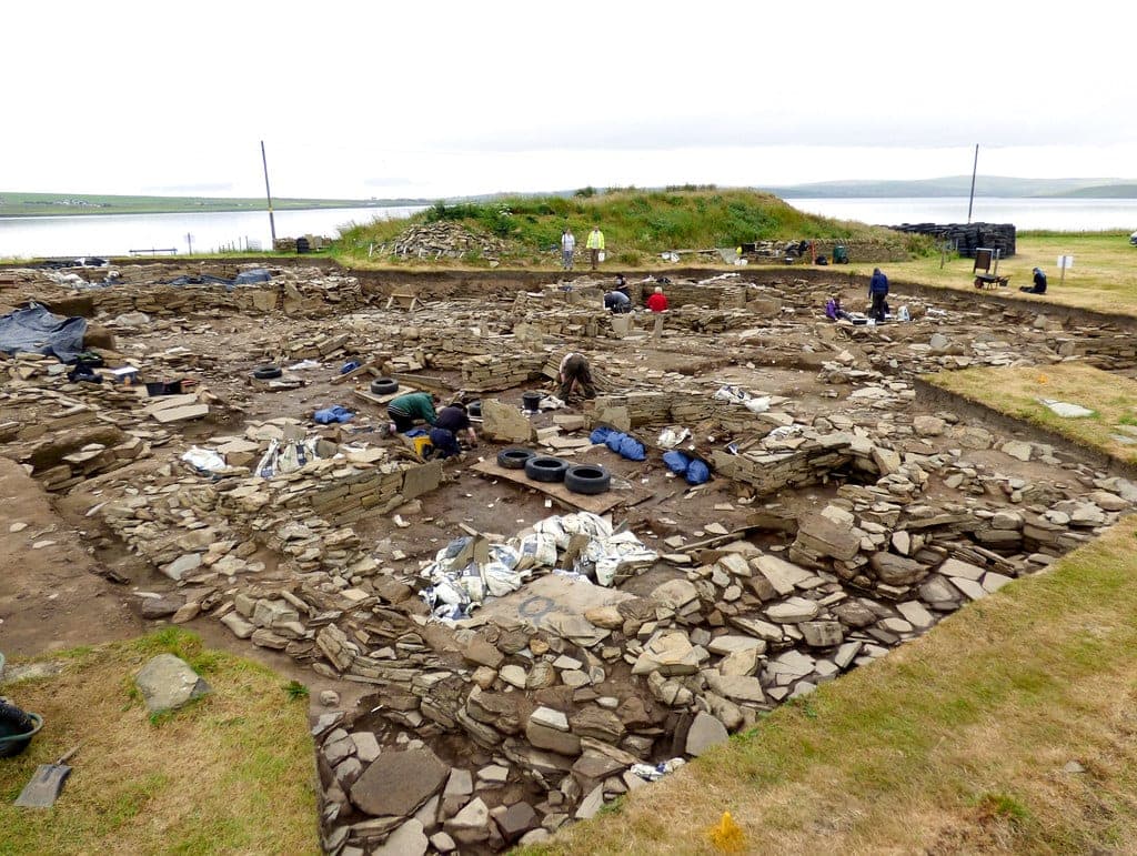
The Standing Stones of Stenness appear as you approach along the Brodgar road, rising from a promontory where two bodies of water nearly meet. To the west lies the Loch of Stenness, connected to the sea and salted by it. To the east lies the Loch of Harray, fed by freshwater streams. The stones stand between these two natures of water, on ground that Neolithic communities chose with evident care. Four stones survive from an original ellipse of eleven or twelve, set on a levelled platform forty-four metres across. Each stone is remarkably thin, perhaps thirty centimetres through, yet they reach heights of five to six metres. They are blades of stone, not pillars. Their sharply angled tops cut against the Orkney sky like something unfinished, or perhaps finished in a way we no longer understand. The platform is surrounded by a rock-cut ditch, two metres deep and seven metres wide, with a single entrance causeway on the north side. This entrance faces directly toward the Barnhouse Settlement, a Neolithic village whose pottery matches the sherds found in the ditch and at the central hearth. The people who lived at Barnhouse walked through that entrance to reach whatever awaited them within the circle. At the centre of the stone ellipse lies a square hearth, two metres across, still visible in the ground. When Graham Ritchie excavated it in 1973, he found ash, burnt bone, charcoal, and broken pottery. The remains of cattle, sheep, and dogs lay in the surrounding ditch. These were not casual fires. Something was fed here, shared here, marked here, over centuries. The stones predate Stonehenge's main stone phase by five hundred years. They stand in the company of Maeshowe, the Ring of Brodgar, the Ness of Brodgar, and Skara Brae, all within walking distance. This landscape concentrated Neolithic ambition and sacred attention like few places anywhere in Europe. What the builders intended has not survived in words. What they built has survived in stone.
Context And Lineage
Possibly the oldest henge in Britain, built around 3100 BC, connected to a Neolithic village, aligned to sun and moon, part of a UNESCO World Heritage landscape, and once home to oath-binding customs that survived into the nineteenth century.
Around 3100 BC, Neolithic communities on the Orkney mainland began constructing a monument on the promontory between two lochs. They levelled a platform forty-four metres across. They cut a ditch into the bedrock, two metres deep and seven metres wide, leaving a single entrance causeway on the north side facing the Barnhouse Settlement where they lived. They raised eleven or twelve thin stone slabs into an ellipse thirty-two metres in diameter, the tallest reaching nearly six metres. At the centre they built a square hearth, two metres across, and in it they burned fires, deposited pottery, and left the bones of cattle, sheep, and dogs. What they sought in doing this we cannot say with certainty. The statistical analysis of the monument's orientation suggests alignments with the summer and winter solstice sunrise and with major lunar standstills, events in the moon's 18.6-year cycle. The probability of these alignments being deliberate exceeds ninety-seven percent. Someone watched the sky for decades, noted patterns, and built accordingly. The site predates the main stone phase of Stonehenge by five hundred years. For centuries the monument served its community. Then Neolithic life on Orkney changed, and the great phase of monument-building drew to a close. But the stones did not lose their power over people. By the eighteenth century, local customs had attached to a nearby stone pierced with a circular hole, known as the Odin Stone. Couples clasped hands through the hole to swear the Odin Oath, the most binding pledge known in Orkney. No instance was ever recorded of anyone breaking it. Newborns were passed through the hole for protection. Offerings of food and ale were left. Then in December 1814, Captain W. Mackay, who had bought farmland near the stones, decided to remove them because local people kept crossing his land to use them. He smashed the Odin Stone first. The community's fury stopped him after he had destroyed one more stone and toppled a third. Walter Scott, visiting that same year, documented what remained.
The Standing Stones of Stenness belong to the Neolithic monument-building tradition of Atlantic Europe, contemporary with the earliest phases of ceremonial architecture in Orkney. They form part of a dense concentration of monuments along the Brodgar-Stenness isthmus that includes the Ring of Brodgar, Maeshowe, the Ness of Brodgar, and Skara Brae. This concentration represents one of the most significant Neolithic ceremonial landscapes in Europe, inscribed as the Heart of Neolithic Orkney UNESCO World Heritage Site in 1999.
Graham Ritchie
Captain W. Mackay
Dr. Gail Higginbottom
Colin Richards
Why This Place Is Sacred
Where salt water and fresh water nearly meet, where domestic settlement faces ceremonial henge, and where five thousand years of silence still hold the ash of ancient fires.
The thinness of Stenness operates through meeting. Salt loch and freshwater loch converge on the isthmus where the stones stand. The Barnhouse Settlement, domestic and daily, faces the henge entrance, ceremonial and extraordinary. The living left offerings in the ditch alongside the bones of their animals. The hearth at the centre burned for generations. This was a place where categories met and dissolved: water and water, home and temple, the living and whatever the living sought to reach. The stones themselves embody this quality. They are extraordinarily thin, barely thirty centimetres through, yet they reach nearly six metres high. They are not massive in the way of Stonehenge. They are delicate, precise, almost fragile-looking despite having stood for five millennia. To stand among them is to feel how intentional their placement was, how carefully these particular shapes were chosen, quarried, transported, and raised.
The Stones of Stenness were erected around 3100-2900 BC as a henge monument whose central hearth served as a focus for communal ceremonial activity. The astronomical alignments with summer and winter solstice sunrise and with major lunar standstills suggest the site functioned partly as a place for observing and marking celestial cycles. The identical pottery found at both the henge and the adjacent Barnhouse Settlement indicates that ceremonial and domestic life were directly connected, with the henge entrance oriented toward the village.
The site remained a focus of activity for centuries during the Neolithic period. By the 18th century, Norse-influenced customs had attached to a nearby stone known as the Odin Stone, where couples sealed marriage pledges and infants were passed through a hole for healing. Captain W. Mackay destroyed the Odin Stone in December 1814, provoking community outrage that stopped further destruction. Graham Ritchie's excavation in 1973-74 revealed the henge ditch, central hearth, and Neolithic deposits. The site became part of the Heart of Neolithic Orkney UNESCO World Heritage Site in 1999.
Traditions And Practice
Walk from Barnhouse to the henge entrance. Stand at the hearth. Watch the light on the stones and the water on either side. Return at a different hour and find a different place.
Neolithic use centred on the hearth within the stone ellipse, where fires burned, pottery was deposited, and animal remains were left in the surrounding ditch. The astronomical alignments suggest ceremonies connected to solstice and lunar standstill events. By the 18th century, the Odin Stone hosted marriage pledges, healing rituals, and oath-taking. Offerings of food and ale accompanied these customs.
Contemporary visitors walk among the stones and visit the adjacent Barnhouse Settlement. Some time their visits to solstice or equinox. The guided ranger walks offered by Historic Environment Scotland provide archaeological context. The path between Stenness and the Ring of Brodgar has become an informal pilgrimage route through the Neolithic landscape.
Begin at the Barnhouse Settlement and walk toward the henge entrance. Cross the threshold as the Neolithic builders intended. Stand at the central hearth and look outward through the stones toward the Ring of Brodgar and Maeshowe. Notice the light on the stone, the water on either side, the sky overhead. If time allows, walk the full route to the Ring of Brodgar, passing the Watch Stone. Return at dawn or dusk to see the stones transformed by low northern light.
Neolithic ceremonial practice
HistoricalThe henge was constructed around 3100-2900 BC with astronomical alignments to solstice and lunar standstill events, centred on a hearth where communal ceremonies took place over centuries.
Ceremonial fires at the central hearth. Deposition of pottery and animal remains. Gatherings that connected the domestic settlement at Barnhouse to the ritual space of the henge.
Odin Stone oath and healing customs
HistoricalBy the 18th century, Norse-influenced customs at the pierced Odin Stone included the most binding form of oath known in Orkney, as well as healing rituals for infants.
Clasping hands through the Odin Stone hole to swear the Odin Oath. Marriage pledges sealed at the stone. Passing newborns through the hole for protection. Leaving offerings of food and ale.
Contemporary pilgrimage and contemplation
ActiveModern visitors walk the Neolithic landscape between Stenness, Brodgar, and Maeshowe as an informal pilgrimage through five thousand years of sacred architecture.
Walking the isthmus route between monuments. Timing visits to solstice or equinox. Attending ranger-guided walks. Contemplation at the central hearth.
Experience And Perspectives
Walk from the Barnhouse Settlement toward the henge entrance. Cross the threshold. Stand at the central hearth where Neolithic fires burned. Let the stones and the lochs and the Orkney light do their work.
The approach matters. If you can, begin at the Barnhouse Settlement, the Neolithic village adjacent to the Loch of Harray whose people built and used this henge. A path leads from the reconstructed house outlines toward the stones. This is the route they walked, from home to ceremony. The henge entrance faces you as you approach from the north, the single causeway across the ditch that admitted visitors for over a thousand years of Neolithic use. Once through the entrance, the surviving stones rise around you. Four remain of the original ellipse, and they are startling in their proportions. The thinness is what strikes you first. These are not squat megaliths but narrow slabs, almost like standing blades, reaching five to six metres into the sky. Their sharply angled tops give them a quality of deliberate shaping that distinguishes them from natural rock. In the centre, the square hearth is still visible, a two-metre outline in the ground. Graham Ritchie found ash and burnt bone here in 1973. Five thousand years have not entirely erased what was burned. Stand at this hearth and look outward through the stones. To the northwest, the Ring of Brodgar is visible on the horizon. Maeshowe lies to the east. You are standing at the centre of a Neolithic world that stretches in every direction, a landscape of monuments built by communities who understood something about this place that drew them back for millennia. The light is particular. Orkney lies at nearly sixty degrees north. In summer, the sun barely sets. In winter, it barely rises. The stones respond to each extreme, casting long shadows in the low northern light, standing shadowless in the endless midsummer glow. The two lochs reflect the sky on either side of the promontory, doubling whatever light exists. Rain arrives and departs quickly. The wind is constant.
The Standing Stones of Stenness occupy a promontory at the southern end of the isthmus between the Loch of Stenness (west, salt water) and the Loch of Harray (east, fresh water). The henge entrance is on the north side, facing the Barnhouse Settlement. Four surviving stones from the original ellipse remain. The central hearth lies at the midpoint. The Ring of Brodgar is visible 1.2 km to the northwest. Maeshowe lies 1.2 km to the east. The Watch Stone stands as an outlier between Stenness and Brodgar.
The Standing Stones of Stenness invite interpretation through archaeology, astronomy, folklore, and direct encounter. Each perspective reveals something the others miss.
Archaeologists regard Stenness as possibly the oldest henge monument in the British Isles, dated to approximately 3100-2900 BC through radiocarbon analysis of animal bones from the ditch. Graham Ritchie's 1973-74 excavation established the site's Neolithic character and its connection to the Barnhouse Settlement through matching pottery. Research by Dr. Gail Higginbottom demonstrated astronomical alignments with solstice sunrise and major lunar standstills at a statistical confidence exceeding 97 percent. The central hearth, animal remains, and pottery deposits suggest communal ceremonial activities whose specific nature remains debated.
By the 18th century, the Odin Stone near the henge hosted customs rooted in Norse tradition. Couples clasped hands through the pierced hole to swear the Odin Oath, considered absolutely binding. Newborns were passed through for protection from disease. Offerings of food and ale accompanied these customs. When Captain Mackay destroyed the stone in 1814, the community's fury reflects how deeply these traditions were woven into Orkney life. Whether the customs preserved echoes of older practices predating the Norse period cannot be determined.
Some observers note the significance of the stones' placement between salt and fresh water, interpreting the promontory as a liminal space where different elements meet and boundaries thin. The concentration of Neolithic monuments along the isthmus has attracted interest from those exploring sacred geography and earth energy systems. The astronomical alignments support interpretations connecting the site to lunar and solar ceremonialism.
The precise ceremonies conducted at the central hearth remain beyond recovery. Whether the henge ditch held water and what symbolic role it played are uncertain. The relationship and sequence of use between Stenness, the Ness of Brodgar, and the Ring of Brodgar is still being investigated through ongoing excavation. What the Odin Stone customs preserved from deeper antiquity, if anything, cannot be established. The builders' understanding of the cosmos, which clearly extended to celestial cycles spanning decades, may have encompassed dimensions we cannot reconstruct.
Visit Planning
On Orkney Mainland, reached by ferry or air. Free and open at all times. No facilities at the stones. Small car park. Ranger walks in summer.
Accommodation available in Stromness and Kirkwall. Limited options in the Stenness area. Book in advance for summer months.
These stones have stood for over five thousand years. Do not climb them. Do not lean against them. Let them stand as they were placed.
The Standing Stones of Stenness are a scheduled ancient monument and part of a UNESCO World Heritage Site. They have survived five millennia of Orkney weather but are not indestructible. Do not climb on or lean against the stones. Do not disturb the ground or remove anything from the site. If other visitors are present, respect their experience. The stones invite contemplation, and silence often serves better than conversation.
Dress for Orkney weather. Waterproofs and warm layers essential. Wind is near-constant and can be strong. Sturdy footwear recommended.
Photography permitted. The thin profiles of the stones photograph dramatically in low light. Dawn and dusk offer the strongest contrasts.
Not traditionally associated with offerings in the modern era. The Odin Stone customs ended with its destruction in 1814. Presence and attention are sufficient.
Do not climb on the stones. Do not disturb the scheduled monument. Leave no trace. No metal detecting.
Sacred Cluster
Nearby sacred places create the location cluster described in the growth plan. This block is intentionally crawlable and links into the wider regional graph.