Ness of Brodgar
Where Neolithic Orkney gathered to feast, build, paint, and finally close a world between the living and the dead
Stenness, Orkney Islands, United Kingdom
At A Glance
- Coordinates
- 59.0003, -3.2293
- Suggested Duration
- Half day combining the Ness walk with both stone circles and Barnhouse Village
Pilgrim Tips
- Dress for Orkney weather. Waterproofs, wind protection, and layers are essential regardless of season. Sturdy footwear recommended for walking between the stone circles.
- Permitted for personal and research purposes. During excavation seasons, photography of the dig is welcomed.
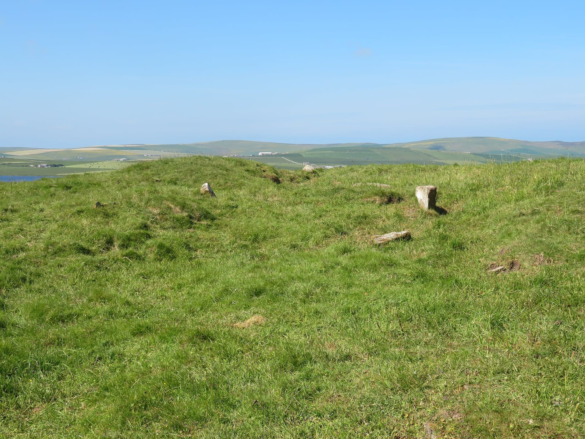
- The excavated structures are currently backfilled and not visible. The site is an open field without interpretation panels or facilities. Orkney weather is unpredictable; wind and rain can arrive without warning.
Overview
On the narrow isthmus between two lochs on Mainland Orkney, the Ness of Brodgar lies at the centre of a Neolithic world. For over a thousand years, communities raised monumental stone buildings here, painted their walls in red and yellow pigment, carved more than a thousand decorated stones, feasted in gatherings that drew people from across the archipelago, and created the largest roofed structure of its era in Britain. Then, around 2200 BC, they slaughtered approximately four hundred cattle, dismantled the great buildings, and walked away.
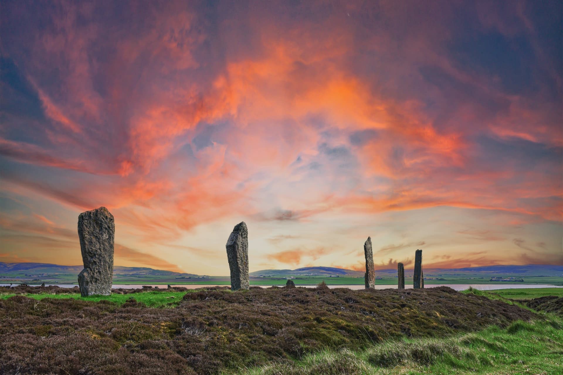
The Ness of Brodgar occupies a strip of land between the Loch of Harray and the Loch of Stenness, one freshwater and one saltwater, divided by this narrow peninsula. To the northwest stands the Ring of Brodgar. To the southeast, the Stones of Stenness. Between them, for thirteen centuries, Neolithic communities constructed something without parallel in Atlantic Europe.
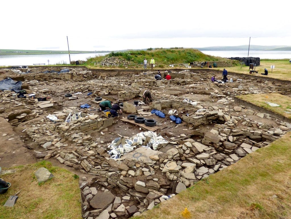
The buildings they raised were not houses and not tombs. The largest, known to archaeologists as Structure Ten, measured twenty-five by twenty metres, the largest roofed Neolithic building ever found in Britain. Its walls were thick, its interior spaces elaborately organized. Other structures, at least a dozen more, filled the peninsula. A boundary wall over seventy metres long and four metres wide, the so-called Great Wall of Brodgar, separated this complex from the world beyond. Whatever happened here was set apart.
What happened here left extraordinary traces. Over a thousand stones were decorated with incised patterns, cup marks, and carved designs. Walls were painted with pigments of red, yellow, orange, and black, made from haematite mixed with animal fat. These are the oldest painted walls in northern Europe. More than eighty thousand sherds of Grooved Ware pottery were recovered. The buildings were not static constructions but were modified, rebuilt, and elaborated over centuries, each generation adding its own layer to a place of continuing significance.
Archaeologists interpret the Ness as a liminal space, a threshold between the land of the living, associated with the Stones of Stenness, and the land of the ancestors, associated with the Ring of Brodgar. The site lies in a natural amphitheatre ringed by hills, aligned to the midwinter rising sun and midsummer sunset. People came here from across Orkney and perhaps from beyond the archipelago. They came to feast, to exchange ideas and objects, and to participate in ceremonies whose precise nature the archaeology can only suggest.
The ending was deliberate. Around 2200 BC, the community gathered for one final act. Approximately four hundred cattle were slaughtered in what appears to have been a single event. The tibias were cracked for marrow, the meat consumed. Red deer carcasses were placed atop the broken bones. The walls of Structure Ten were partially dismantled, the interior filled with rubble and midden, the building transformed into a mound. An entire era of Neolithic life was formally, ceremonially, brought to a close.
Context And Lineage
A Neolithic ceremonial complex of unprecedented scale, active for over 1,300 years, ceremonially closed around 2200 BC, and rediscovered in the 21st century beneath an Orkney field.
Sometime around 3500 BC, Neolithic communities in Orkney began constructing buildings on the narrow isthmus between two lochs. This was already a significant landscape: the Stones of Stenness were being erected nearby, and the Ring of Brodgar would follow. The peninsula between them, naturally aligned to the midwinter sunrise and midsummer sunset, became the focus of architectural ambition that would continue for over thirteen centuries.
By 3300 BC, the complex was substantial enough to require definition. The Great Wall of Brodgar was raised across the width of the peninsula, seventy metres long and four metres wide, marking the boundary of sacred space. Within this enclosure, monumental buildings were constructed, modified, demolished, and rebuilt. Each generation inherited the work of the last and added its own contribution.
The buildings were remarkable. Structure Ten, dating from the later centuries of the complex, measured twenty-five by twenty metres and was the largest roofed structure of its era in Britain. The walls of multiple buildings were painted with pigments ground from haematite and mixed with animal fat, milk, or eggs, creating interiors coloured in red, yellow, orange, and black. Over a thousand stones were decorated with incised patterns. More than eighty thousand sherds of Grooved Ware pottery were produced and used. This was not a settlement but a gathering place, somewhere communities came together from across Orkney and beyond for feasting, ceremony, and exchange.
The ending came around 2200 BC. The community slaughtered approximately four hundred cattle in what radiocarbon dating suggests was a single event. The meat was consumed in a massive feast. The tibias were cracked for marrow. Red deer carcasses were placed atop the remains. The walls of Structure Ten were dismantled, the interior filled, the building transformed into a mound. The complex was closed with a ceremony as deliberate and significant as any of those that had preceded it across a millennium of use. Then the people walked away, and the Orkney grass grew over what they had built.
The Ness of Brodgar belongs to the extraordinary concentration of Neolithic ceremonial monuments in Orkney, including the Stones of Stenness, Ring of Brodgar, Maeshowe, Skara Brae, and Barnhouse. The Grooved Ware pottery tradition found in abundance at the Ness may have originated in Orkney before spreading across Britain and Ireland. The site has fundamentally changed scholarly understanding of Neolithic society, demonstrating levels of organisation, artistic expression, and ceremonial complexity previously unimagined for this period.
Nick Card
Excavation Director
Why This Place Is Sacred
The Ness of Brodgar stands at a threshold in every sense: between two lochs, between two stone circles, between the living and the dead, between a world being made and a world being unmade.
The thinness of the Ness operates through convergence. The peninsula itself is a threshold, a narrow strip of land dividing freshwater from saltwater, two bodies that meet but do not mix. The archaeological interpretation extends this liminality further: the Stones of Stenness to the southeast are associated with the activities of the living, the Ring of Brodgar to the northwest with the domain of the ancestors. The Ness lies between, a place of crossing.
This was not accidental. The Neolithic builders chose this precise location and marked it with constructions of extraordinary ambition. The Great Wall of Brodgar, seventy metres long and four metres wide, did not merely define a boundary. It created one. Whatever lay within was separated from the everyday world by stone so massive it could not be ignored. Entry into this space was controlled, deliberate, meaningful.
Inside, the buildings were not merely functional. They were decorated. Painted. The application of pigment to stone walls, the earliest known in northern Europe, suggests interiors designed to create specific experiences. Walking into a Neolithic building with walls coloured in red, yellow, and orange, lit by firelight, would have been entering a transformed space. The carved and incised stones, over a thousand of them, added pattern and symbol to the environment. These were spaces made for something beyond the ordinary.
The closing of the site deepens the sense of threshold. The slaughter of four hundred cattle, the deliberate demolition, the placement of red deer carcasses, the transformation of a cathedral-scale building into a mound. This was not destruction but ceremony. An entire community participated in ending what their ancestors had begun thirteen centuries earlier. They chose to close the door between worlds, and they did so with an act so extravagant that its traces are unmistakable five thousand years later.
Today the structures are buried. The isthmus is an open field between two stone circles. The thinness persists not in visible remains but in the quality of the place itself: the light over two lochs, the encircling hills, the knowledge of what lies beneath.
The complex functioned as a major ceremonial centre from approximately 3500 to 2200 BC. The monumental buildings, boundary walls, painted interiors, and evidence of large-scale feasting indicate a site where communities gathered for ritual, feasting, exchange, and ceremonies marking the boundary between the living and the ancestral dead.
Activity began around 3500-3400 BC. The Great Wall of Brodgar was raised around 3300 BC and deliberately reduced to its current height by 3000 BC. Structure Ten, the largest building, was constructed and used until 2400-2200 BC, when the entire complex was ceremonially closed. The site lay buried for millennia until geophysical survey identified anomalies in 2002-2003. Excavations led by Nick Card of the Orkney Research Centre for Archaeology ran from 2003 to 2024. The exposed structures were then backfilled for preservation. A new excavation is planned for July 2026, prompted by ground-penetrating radar findings.
Traditions And Practice
No active ritual tradition continues at the site. The landscape invites contemplative walking between the two stone circles, traversing the threshold the Neolithic builders defined.
The Neolithic communities who used the Ness of Brodgar practiced large-scale communal feasting within and around monumental buildings. They decorated interior walls with painted pigments and carved elaborate patterns into stone. They constructed, modified, and reconstructed buildings over centuries, maintaining the complex as a living ceremonial space. The ceremonial closing involved the slaughter of approximately four hundred cattle, a communal feast, the placement of red deer carcasses, and the deliberate demolition and burial of the principal buildings.
Contemporary visitors walk the isthmus between the Ring of Brodgar and the Stones of Stenness, traversing the same threshold that the Neolithic complex marked. During excavation seasons, guided tours provide direct engagement with the archaeological process. The Orkney Museum in Kirkwall displays finds from the excavation. The wider Heart of Neolithic Orkney landscape, including Maeshowe, Skara Brae, and both stone circles, can be experienced as a connected ceremonial landscape.
Walk from the Stones of Stenness to the Ring of Brodgar along the isthmus. Pause where the peninsula narrows between the two lochs. Consider that you stand above painted rooms and carved stones, above a place where thousands gathered to feast and mark the passage between the living and the dead. Let the Orkney wind and light work on you. Visit the Orkney Museum to see the decorated stones and pottery recovered from the site. If your visit coincides with the 2026 excavation season, join a guided tour for direct contact with the archaeology.
Neolithic Ceremonial Complex
HistoricalFor approximately 1,300 years (c. 3500-2200 BC), the Ness of Brodgar functioned as the ceremonial heart of Neolithic Orkney, a gathering place where communities built monumental structures, painted interior walls, created elaborate stone art, and participated in large-scale feasting. The complex occupied a liminal position between the living and the ancestral dead, marked by its location between the Stones of Stenness and the Ring of Brodgar.
Communal feasting, ceremonial construction and reconstruction, wall painting with mineral pigments, stone decoration, Grooved Ware pottery production, and ritual activities marking the threshold between the living and the dead. The complex was ceremonially closed around 2200 BC with the slaughter of approximately 400 cattle.
Orcadian Folklore and Memory
ActiveLocal traditions preserved fragments of awareness about the Ness even after the Neolithic complex was forgotten. Stories of a giant's severed hand forming the peninsula, and references to druidic sun temples, indicate that the landscape's special character was sensed if not archaeologically understood.
Oral storytelling and place-name traditions. The two standing stones visible on the Ness before excavation were known and named.
Experience And Perspectives
Walk the isthmus between the Ring of Brodgar and the Stones of Stenness. Stand where the Ness narrows between freshwater and saltwater. Let the landscape speak of what lies beneath.
The Ness of Brodgar does not reveal itself easily. The structures are buried. The painted walls are protected beneath earth. The decorated stones are in storage or museum collections. What you encounter is landscape, and on Orkney, landscape is never insufficient.
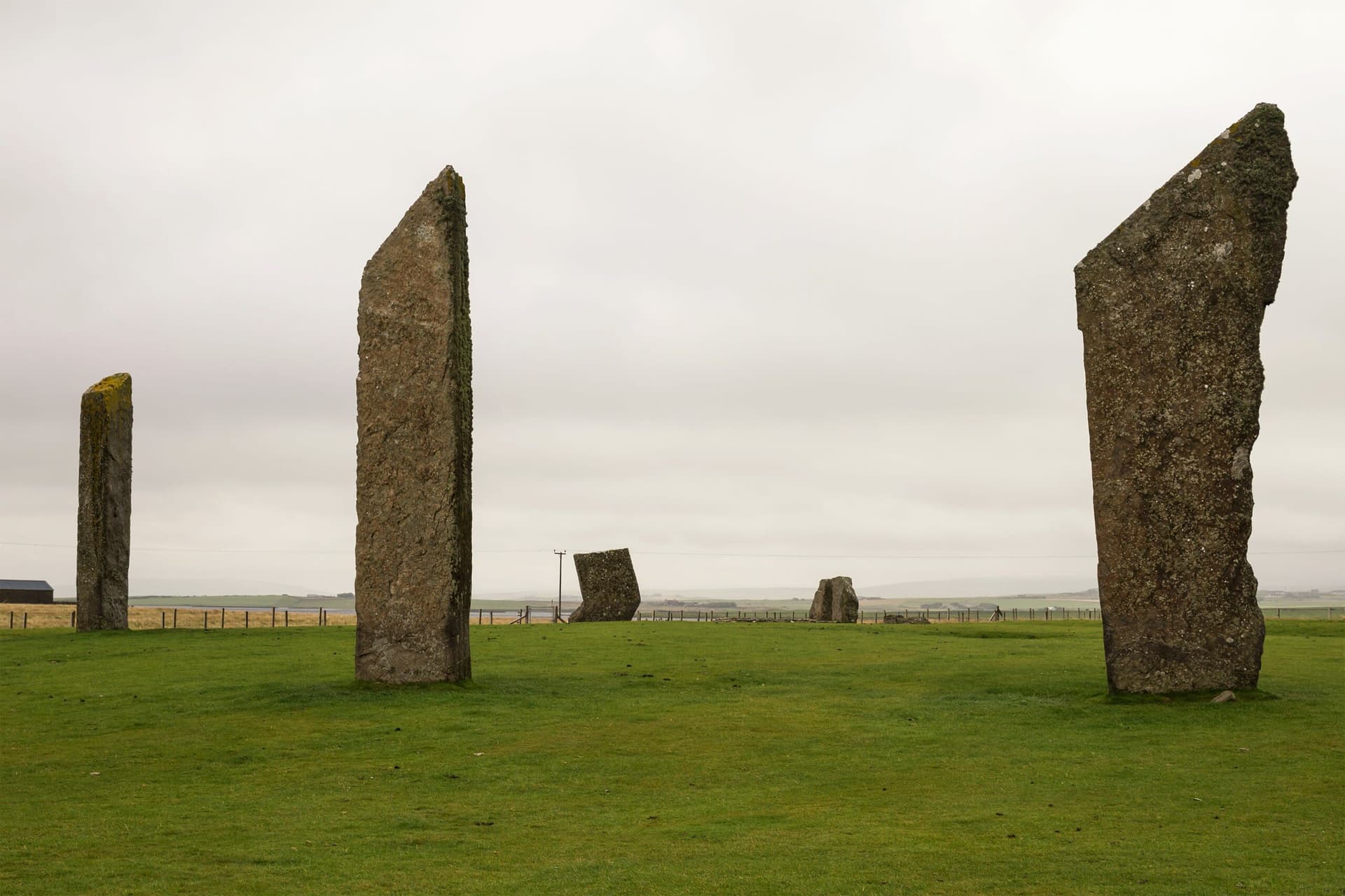
Begin at the Stones of Stenness, the domain the Neolithic builders associated with the living. Four tall stones remain from the original twelve, standing in a henge surrounded by a ditch. The Watchstone, a solitary monolith over five metres tall, stands between Stenness and the Ness, marking the start of the transition. Walk northwest along the isthmus.
The lochs open on either side. To the east, the Loch of Stenness, its water salt-tinged from the sea. To the west, the freshwater Loch of Harray. The peninsula narrows. You are walking on what Neolithic communities sealed with a four-metre-wide wall. Beneath your feet, the remains of buildings whose interiors were painted in colours mixed from ground stone and animal fat. The field gives no sign of this. The knowledge transforms the walk.
As you continue northwest, the Ring of Brodgar comes into view. Twenty-seven stones remain from what was originally a ring of sixty, set within a ditch carved into solid bedrock. This is the domain the Neolithic builders associated with the ancestors, the dead. You have crossed from the living to the dead, traversing the threshold that the Ness of Brodgar marked and mediated for over a millennium.
The surrounding landscape adds layers of meaning. Maeshowe, the finest chambered cairn in Europe, lies a mile to the east. Its entrance passage aligns with the midwinter sunset, and the same celestial geometry that oriented Maeshowe also informed the positioning of the Ness. The hills ring the horizon in every direction, creating the natural amphitheatre within which this entire ceremonial landscape was constructed.
The experience is contemplative rather than spectacular. There is nothing to see in the conventional archaeological sense. There is everything to feel. The wind off the lochs, the Orkney light shifting through cloud and sun, the vast sky, and the knowledge that you walk above one of the most significant ceremonial complexes ever built in prehistoric Europe.
The Ness of Brodgar lies on the isthmus between the Loch of Harray (west) and the Loch of Stenness (east), between the Ring of Brodgar (northwest) and the Stones of Stenness (southeast). The site is approximately 11 miles from Kirkwall and 5 miles from Stromness, accessed via the B9055 off the A965. Car parks are located at both stone circle sites.
The Ness of Brodgar invites interpretation through archaeology, landscape studies, and contemplation of what it means for a community to build, maintain, and deliberately close a ceremonial world over thirteen centuries.
Archaeologists regard the Ness of Brodgar as one of the most significant Neolithic discoveries of the 21st century. Twenty years of excavation under Nick Card revealed a complex of monumental buildings unprecedented in Atlantic Europe, with painted walls representing the earliest known use of decorative pigment in northern Europe, over a thousand decorated stones, and more than eighty thousand sherds of Grooved Ware pottery. The site's interpretation as a liminal threshold between the living and the ancestral dead, supported by its position between the Stones of Stenness and the Ring of Brodgar, has become a widely discussed framework. The ceremonial closing, involving the slaughter of approximately four hundred cattle and the deliberate demolition of Structure Ten, is interpreted as marking the end of a major phase of Neolithic society in Orkney.
No continuous oral tradition survives from the Neolithic period. Local folklore includes a creation myth describing the Brodgar peninsula as the severed hand of a god or giant, dividing the two lochs. Two standing stones on the Ness were known historically as the stones of Saturn and Jupiter, associated with druidic sun worship. These fragments suggest that the site's special character was recognised, if not understood, across the intervening millennia.
Some interpret the site as a Neolithic healing centre or place of spiritual transformation, drawing on the liminal landscape and the painted interiors as evidence of spaces designed to alter consciousness. The convergence of freshwater and saltwater, the solstice alignments, and the encircling hills have attracted interest from those who understand sacred geography as a response to earth energies or telluric forces.
The precise nature of the ceremonies conducted within the painted buildings remains unknown. Whether the mass cattle slaughter represents the end of a political order, a religious transformation, or a deliberate societal choice to move beyond a ceremonial tradition cannot be determined from the archaeology alone. The full extent of the complex is still uncertain, as only a fraction of the estimated site has been excavated. The relationship between the Ness and the broader spread of Grooved Ware culture across Britain and Ireland is an active area of research.
Visit Planning
Between the Ring of Brodgar and the Stones of Stenness on Mainland Orkney. Accessible year-round as open landscape. Excavation tours planned for July 2026. No on-site facilities.
Stromness (5 miles) offers hotels, B&Bs, and self-catering. Kirkwall (11 miles) provides a wider range. Book well in advance for summer visits. Several accommodations near the site itself.
The site is an archaeological landscape within a UNESCO World Heritage area. Walk with awareness. Do not dig, disturb the ground, or remove materials. Respect the significance of what lies beneath.
The Ness of Brodgar is both an archaeological site and a place where Neolithic communities invested thirteen centuries of ceremonial intention. The structures are buried but not gone. Walk the landscape with the same care you would bring to any place of deep significance. Do not attempt to dig or probe the ground. During excavation seasons, follow the guidance of site staff and respect restricted areas. The UNESCO World Heritage designation reflects the global importance of this landscape.
Dress for Orkney weather. Waterproofs, wind protection, and layers are essential regardless of season. Sturdy footwear recommended for walking between the stone circles.
Permitted for personal and research purposes. During excavation seasons, photography of the dig is welcomed.
Not traditionally associated with offerings. Presence and attention are appropriate.
Do not dig, probe, or disturb the ground. Do not use metal detectors. During excavation seasons, follow site staff guidance and observe restricted areas. Keep dogs on leads.
Sacred Cluster
Nearby sacred places create the location cluster described in the growth plan. This block is intentionally crawlable and links into the wider regional graph.