Mt. Taylor, New Mexico
Where Navajo, Acoma, Laguna, Zuni, and Hopi creation stories converge on a single volcanic summit
Cibola County, New Mexico, United States
At A Glance
- Coordinates
- 35.2387, -107.6082
- Suggested Duration
- The Gooseberry Springs Trail round trip takes 4 to 5 hours for fit hikers. A full day allows time for summit contemplation and unhurried descent. Overnight camping within the national forest is possible for those seeking extended immersion in the mountain's landscape.
- Access
- From Interstate 40, take the Grants exit and drive east on old Route 66 to the junction with NM 547. Take NM 547 north through Grants for approximately 15 miles. Just before the pavement ends, turn right on Forest Road 193, a dirt road. Drive about 5 miles to the Gooseberry Springs Trailhead on the left. The forest road can be rough and may be impassable when wet or snow-covered; high-clearance vehicles are recommended. No entrance fee for hiking. Mobile phone signal is unreliable on the mountain and in the surrounding forest. The town of Grants, approximately 20 miles south, is the nearest settlement with reliable services and phone signal. Contact the Mount Taylor Ranger District at 505-287-8833 for current road and trail conditions.
Pilgrim Tips
- From Interstate 40, take the Grants exit and drive east on old Route 66 to the junction with NM 547. Take NM 547 north through Grants for approximately 15 miles. Just before the pavement ends, turn right on Forest Road 193, a dirt road. Drive about 5 miles to the Gooseberry Springs Trailhead on the left. The forest road can be rough and may be impassable when wet or snow-covered; high-clearance vehicles are recommended. No entrance fee for hiking. Mobile phone signal is unreliable on the mountain and in the surrounding forest. The town of Grants, approximately 20 miles south, is the nearest settlement with reliable services and phone signal. Contact the Mount Taylor Ranger District at 505-287-8833 for current road and trail conditions.
- Standard mountain hiking gear. Sturdy boots for rocky trail surfaces. Layers for significant temperature variation between the desert trailhead and the 11,301-foot summit. Rain gear for afternoon thunderstorms in summer. Sun protection at all elevations.
- Photography of natural scenery is permitted within the national forest. Do not photograph shrines, offerings, ceremonial objects, or people engaged in ceremonial practices. If you encounter cultural features on the summit or elsewhere, treat them as you would the interior of any active sanctuary.
- Do not disturb shrines, offerings, prayer sticks, feathers, or any ceremonial materials encountered on the mountain. Do not photograph them. If you encounter indigenous people conducting ceremonies or collecting materials, give them privacy and space. The summit shrine is an active sacred site. Afternoon thunderstorms in summer are dangerous above treeline. Forest Road 193, the access road to the Gooseberry Springs Trailhead, is a dirt road that can become impassable when wet or snow-covered.
Overview
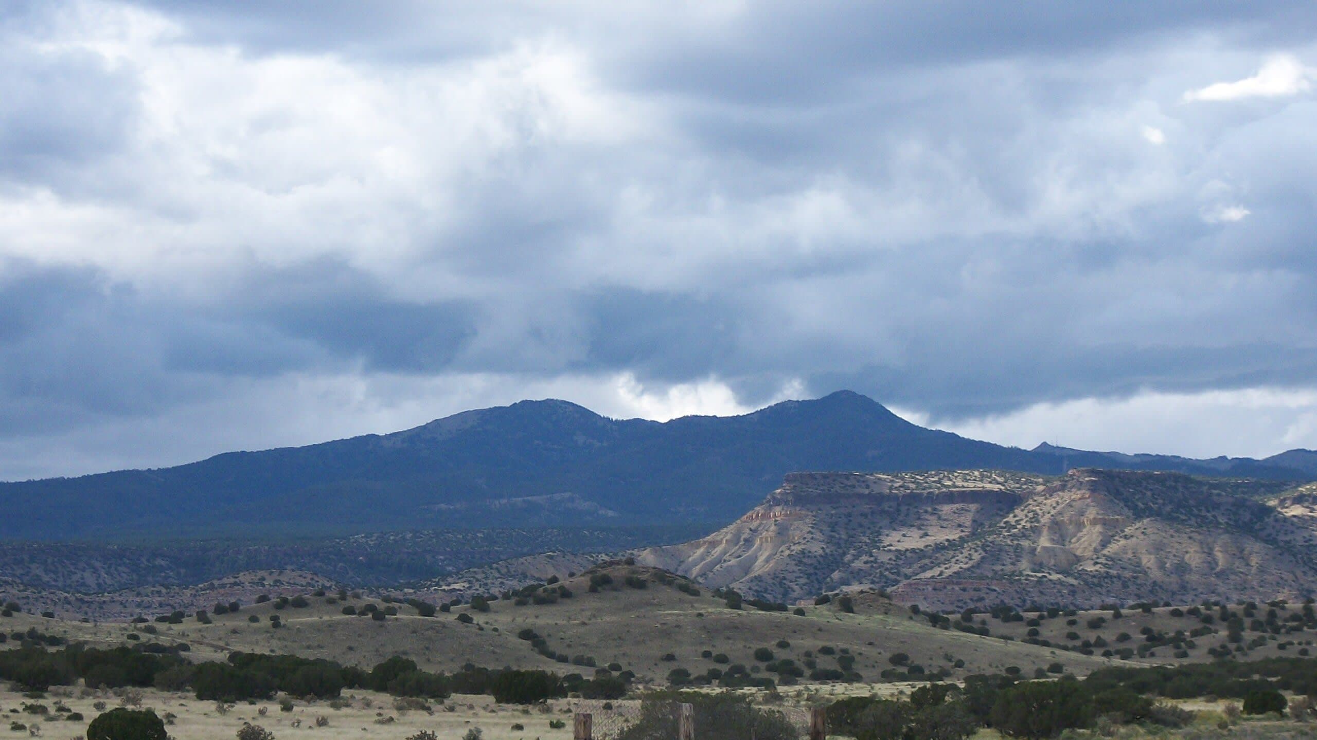
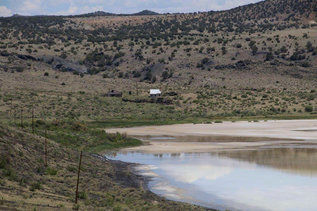
Mount Taylor rises to 11,301 feet above the desert of western New Mexico, a dormant stratovolcano visible from vast distances. At least 30 indigenous tribes consider it a pilgrimage destination. For the Navajo, it is Tsoodził, the southern boundary of the world. For the Acoma, it is Kaweshtima, home of the Goddess of Creation. A summit shrine with four ancient trails from four different pueblos marks the place where distinct cosmologies meet on common ground.
Few mountains carry the weight that Mount Taylor does. Visible for a hundred miles across the desert of western New Mexico, this dormant stratovolcano has been named and narrated by more indigenous traditions than perhaps any other peak on the continent. The Navajo call it Tsoodził, Turquoise Mountain, and understand it as one of the four sacred mountains that define the boundaries of the world. First Man created it from soil brought from the Fourth World and fastened it to the earth with a stone knife. The Acoma call it Kaweshtima, Place of Snow, and locate here the home of their Goddess of Creation and the rain deity Ca'kak. The Laguna know it as Tsibina. The Zuni call it Dwankwi Kyabachu Yalanne. The Hopi name it Tsiipiya.
Five names, five cosmologies, one mountain. This convergence is not coincidence. Mount Taylor dominates its landscape with the authority of a peak that has been accumulating volcanic mass for nearly three million years. It is the kind of mountain that compels stories, that demands to be located within a sacred framework, that refuses to be merely scenery.
On the summit, a shrine documented as early as 1918 sits at the convergence of four ancient trails from Laguna, Acoma, Zuni, and Taos. Religious leaders from these communities still make pilgrimages to collect water from the mountain's springs for ceremonies at the pueblos below. Pine boughs are gathered for ritual dances. Logs are cut for kiva construction. Spirit pathways crisscross the mountain, described by Pueblo peoples as conduits between the natural and supernatural realms.
Beneath this living sacred landscape, uranium deposits have attracted mining companies since the 1950s. The tension between extraction and reverence is Mount Taylor's contemporary struggle, and in 2009 five tribes succeeded in having the mountain designated as a Traditional Cultural Property, covering over 400,000 acres. The designation does not end the threat, but it gives indigenous voices legal standing in decisions about the mountain's future.
Context And Lineage
Mount Taylor is a dormant stratovolcano sacred to at least 30 indigenous tribes and central to the creation narratives of five: Navajo, Acoma, Laguna, Zuni, and Hopi. Renamed for President Zachary Taylor in 1849, it has been a battleground between extraction and reverence since the 1950s uranium boom. A Traditional Cultural Property designation in 2009, covering over 400,000 acres and upheld by the New Mexico Supreme Court, provides legal recognition of the mountain's living sacred significance.
The Navajo tell of First Man creating Tsoodził from soil brought from the Fourth World. He planted it as the southern sacred mountain and decorated it with a blanket of blue cloud, dark mists, and female rain. Turquoise Girl was told to live there. A stone knife was thrust through the mountain from top to bottom to fasten it to the earth. The supernatural beings Black God, Turquoise Boy, and Turquoise Girl reside upon it. To be within sight of Tsoodził and its three companion peaks is to be within the Dinetah, the homeland.
The Acoma tell a different story with the same conclusion: this mountain matters. In the beginning, two sisters, Nautsiti and Iatiku, were born beneath the earth at Shipapu. Guided by Thought Woman, they emerged into the light carrying baskets with seeds and animal fetishes to complete the world. They created the mountains, beginning at Kaweshtima in the north, placing specific plants and animals on each. The mountain is the home of the Goddess of Creation and the dwelling place of Ca'kak, the deity who brings rain and snow to sustain the Acoma people.
The Spanish renamed the mountain for President Zachary Taylor in 1849. The American name carried no sacred weight, but it stuck, an act of cartographic erasure that did not diminish the mountain's significance for the communities that had been naming and praying to it for centuries.
The human relationship with Mount Taylor extends back thousands of years, through successive indigenous cultures who recognized the volcanic peak as sacred. The archaeological record, though less studied than the mountain's ceremonial significance out of respect for its sacred status, indicates long-standing human presence. The Navajo, Acoma, Laguna, Zuni, and Hopi traditions that honor the mountain today represent the continuation of a relationship far older than their individual tribal identities.
The colonial period brought renaming and dispossession. The 20th century brought uranium mining. Between the 1950s and 1980s, the Grants Mineral Belt became one of the largest uranium-producing regions in the world, and the mining devastated the Laguna Pueblo community in particular, contaminating land and water with radioactive waste. The irony was not lost on the communities: the mountain that sustained their ceremonial life was being hollowed out for material to build nuclear weapons.
The 2009 TCP designation and its 2014 Supreme Court confirmation represent a turning point, but not an ending. Uranium mining interests continue to press for access, and the designation strengthens tribal voice without legally preventing extraction. The fight for Mount Taylor is ongoing.
First Man (Navajo)
creator
In Navajo creation narrative, First Man created Mount Taylor from Fourth World soil, decorated it with blue cloud and female rain, fastened it with a stone knife, and established it as the southern boundary of the Dinetah.
Nautsiti and Iatiku
creators
The two sisters who emerged from Shipapu in the Acoma creation narrative and created the mountains beginning at Kaweshtima, placing plants and animals on each to complete the world.
Elsie Clews Parsons
ethnographer
Anthropologist who in 1918 documented the summit shrine and four pilgrimage trails, providing the earliest detailed Western description of the mountain's ceremonial infrastructure. Her documentation would later support the TCP designation.
Conroy Chino
cultural advocate
Emmy Award-winning Acoma Pueblo journalist who has documented and advocated for the cultural significance of sacred sites including Mount Taylor, providing an authoritative indigenous voice in public discourse about the mountain's protection.
Five Tribes TCP Coalition
conservation advocates
Representatives of the Acoma, Laguna, Zuni, Hopi, and Navajo nations who prepared the Traditional Cultural Property application in 2007, submitting extensive statements that resulted in the 2009 designation of over 400,000 acres on the New Mexico State Register of Historic Places.
Why This Place Is Sacred
Mount Taylor's thinness arises from the extraordinary convergence of multiple indigenous cosmologies on a single volcanic peak, the presence of active shrines and spirit pathways, and the mountain's geological character as a conduit between the Earth's interior and the surface. No other mountain in the Southwest concentrates so many creation narratives in one place.
The mountain's power begins with its physical presence. A dormant stratovolcano formed between 2.88 and 2.52 million years ago, Mount Taylor rises abruptly from the surrounding desert to 11,301 feet, its snow-capped peak visible from distances that make it a natural orientation point for the entire region. For the Navajo, whose Four Sacred Mountains define the boundaries of the Dinetah, Mount Taylor marks the southern edge of the known world. To be within sight of all four mountains is to be within the homeland. The mountain functions not as a symbol of boundary but as the boundary itself.
For the Acoma, whose pueblo sits 30 miles to the south atop a sandstone mesa, Kaweshtima is where creation began. The sisters Nautsiti and Iatiku placed the first plants and animals on the mountains beginning here in the north. The deity Ca'kak resides on the summit and sends rain and snow to sustain the communities below. This is not a story about the past. The rain still falls. The springs still flow. Acoma religious leaders still collect water from the mountain's flanks for ceremonies at the pueblo.
What makes this thinness extraordinary is the convergence. The summit shrine, documented by ethnographer Elsie Clews Parsons in 1918 as a large excavated hollow with four well-marked trails leading from four different communities, embodies a rare phenomenon: a place where distinct indigenous nations, each with their own cosmology, independently recognized the same mountain as sacred and created overlapping pilgrimage systems oriented toward the same summit. The trails from Laguna, Acoma, Zuni, and Taos converge not because these peoples share a religion but because something about the mountain compelled each of them to claim it.
Spirit pathways crisscross the landscape. In Pueblo understanding, these are not metaphorical but functional conduits between the natural and supernatural realms. The volcanic origin of the mountain, its direct connection to the Earth's interior through once-molten rock, reinforces the sense that this is a place where what lies beneath and what lies above are unusually close to the surface.
Mount Taylor has served as a sacred center for indigenous peoples for millennia. The summit shrine, with its four pilgrimage trails, functioned as a shared sacred destination where members of different Pueblo communities made offerings and conducted ceremonies oriented toward the mountain's deities and spiritual forces. For the Navajo, the mountain served as a cardinal boundary marker and a source of sacred materials for the Blessing Way Ceremony. The mountain was simultaneously a dwelling place of deities, a source of ceremonial materials, a boundary of the sacred homeland, and a nexus of spirit pathways.
The mountain's sacred status has survived colonial renaming in 1849, the Pueblo Revolt of 1680, the devastating uranium mining boom of the 1950s through 1980s, and ongoing extraction pressures. The 2009 Traditional Cultural Property designation, covering over 400,000 acres and upheld by the New Mexico Supreme Court in 2014, represents a modern legal expression of what the indigenous communities have maintained for centuries: this mountain must be protected because its sacredness is not historical but present.
Traditions And Practice
Mount Taylor sustains active ceremonial life for multiple indigenous communities. Navajo practitioners collect sacred materials for the Blessing Way Ceremony. Acoma religious leaders make pilgrimages to the summit shrine and collect water from the mountain's springs. At least 30 tribes consider the mountain a pilgrimage destination. General visitors hike the mountain through the Cibola National Forest.
The Navajo collect soil, tobacco, minerals, and medicines from Mount Taylor to create the Mountain Soil Bundle, an essential component of the Blessing Way Ceremony, one of the most important Navajo sacred practices. The mountain's role in this ceremony connects its physical substance to the healing and protection of the Navajo people.
For the Acoma, the summit shrine is the best known of many blessing places maintained on the mountain. Religious leaders make pilgrimages to collect water from springs on the mountain's flanks, water that is brought back to the pueblo for use in rituals. Sacred pine boughs held by dancers during ceremonies are gathered from the mountain's forests. Logs used in the construction of kivas are sourced from the mountain's slopes. The mountain is not merely a place to visit but a source of the physical materials that make Acoma ceremonial life possible.
The four-trail pilgrimage system documented in 1918, with paths converging on the summit from Laguna, Acoma, Zuni, and Taos, indicates a shared sacred geography in which distinct Pueblo communities oriented their ceremonial lives toward the same peak. Spirit pathways crisscrossing the mountain serve as conduits between the natural and supernatural realms, channels through which prayers and ceremonial announcements are transmitted.
Indigenous ceremonial use of the mountain continues today. The specific details of contemporary ceremonies are kept private by the communities that conduct them. The TCP designation explicitly recognizes the mountain's ongoing sacred use as the basis for its protection.
For general visitors, the mountain is accessible as a hiking destination within the Cibola National Forest. The annual Mt. Taylor Winter Quadrathlon, held each February, draws participants for a 44-mile multi-sport race involving biking, running, skiing, and snowshoeing. The race reflects the mountain's secular recreational identity, which coexists, not always comfortably, with its sacred status.
Begin the hike at Gooseberry Springs with the awareness that you are ascending one of the most heavily storied mountains on the continent. Notice the ecological transitions as you climb: the shift from pinon-juniper to ponderosa pine, from pine to spruce-fir, from forest to summit meadow. Each transition represents a threshold, and the indigenous traditions that honor this mountain understand these thresholds as more than botanical.
At the summit, take time to absorb the view. To the south lies Acoma territory, the sandstone mesa of Sky City visible on clear days. To the north and west, the Colorado Plateau extends toward Navajo lands and the other sacred mountains that define the Dinetah. You are standing at a place where at least five distinct cosmologies converge, a rare occurrence on this planet. You do not need to hold all these traditions to recognize the significance of the convergence.
If you encounter the summit shrine, do not approach it closely. Observe from a distance. The shrine has been maintained for centuries by communities for whom it is among the most important of all blessing places. Your role here is witness, not participant.
Navajo (Dine)
ActiveMount Taylor is Tsoodził, Turquoise Mountain, one of the Four Sacred Mountains that define the boundaries of the Dinetah. It marks the southern boundary and is associated with the direction south, the color turquoise, and female gender. First Man created it from Fourth World soil and fastened it to the earth with a stone knife. The supernatural beings Black God, Turquoise Boy, and Turquoise Girl reside upon it.
Navajo practitioners collect soil, tobacco, minerals, and medicines from the mountain to create the Mountain Soil Bundle, an essential component of the Blessing Way Ceremony. The mountain serves as a boundary marker for the Navajo homeland and as a cardinal orientation point for ceremonies and prayers.
Acoma Pueblo
ActiveMount Taylor is Kaweshtima, Place of Snow, home of the Goddess of Creation and the rain deity Ca'kak. In the Acoma creation narrative, the sisters Nautsiti and Iatiku created the mountains beginning at Kaweshtima, placing plants and animals on each to complete the world. The summit shrine is the best known of many blessing places maintained by the Acoma on the mountain.
Religious leaders make pilgrimages to the summit shrine and to springs on the mountain's flanks to collect water for rituals at the pueblo. Sacred pine boughs held by dancers in ceremonies and logs used in kiva construction are sourced from the mountain's forests. Spirit pathways on the mountain serve as conduits for prayer and ceremonial communication between the natural and supernatural realms.
Laguna Pueblo
ActiveMount Taylor is Tsibina for the Laguna people, whose pueblo lies at the mountain's southeastern base. A pilgrimage trail from Laguna to the summit shrine was documented in 1918, indicating a long-standing ceremonial relationship. Laguna was among the five tribes that actively sought TCP designation to protect the mountain.
Pilgrimage to the summit shrine and seasonal ceremonies connected to the mountain. Laguna's proximity to the mountain makes it particularly vulnerable to the impacts of uranium mining on sacred water sources.
Zuni Pueblo
ActiveMount Taylor is Dwankwi Kyabachu Yalanne for the Zuni people. A marked pilgrimage trail from Zuni to the summit shrine was documented in 1918. The Zuni prepared extensive statements for the TCP application affirming the mountain's sacred significance within their tradition.
Pilgrimage to the summit shrine and seasonal ceremonies connected to the mountain. The specific details of Zuni ceremonial practice at the mountain are kept private.
Hopi
ActiveMount Taylor is Tsiipiya for the Hopi people. Although the Hopi homeland lies in northeastern Arizona, the Hopi tribe prepared extensive statements for the TCP application and actively participated in efforts to protect the mountain from uranium mining, affirming its significance within Hopi tradition.
Conservation and legal protection
ActiveThe 2009 Traditional Cultural Property designation, covering over 400,000 acres and upheld by the New Mexico Supreme Court in 2014, represents one of the most significant legal recognitions of indigenous sacred landscape in the United States. The National Trust for Historic Preservation, Earthworks, and other organizations have supported the mountain's protection.
The TCP designation does not prevent mining outright but requires consultation with tribal communities before federal permits are granted, giving indigenous voices legal standing in decisions about the mountain's future. The Mount Taylor Ranger District of the Cibola National Forest manages recreational use. Ongoing advocacy by tribal leaders and conservation organizations works to strengthen protections against uranium mining.
Experience And Perspectives
The hike to Mount Taylor's summit passes through multiple ecological zones, from desert sagebrush through ponderosa pine and spruce-fir forest to alpine meadow. The trail is moderate in difficulty and sees far fewer visitors than comparable peaks. Summit views extend across the Colorado Plateau and the Rio Grande Valley, and the awareness of the mountain's sacred layering adds dimension to what might otherwise be a straightforward mountain walk.
From the Gooseberry Springs Trailhead, the path climbs through forest that changes character with elevation. The lower slopes are cloaked in pinon and juniper, the characteristic woodland of the Southwest high desert. Higher, ponderosa pine takes over, their vanilla-scented bark warming in the sun. Higher still, spruce and fir close in, the trail narrowing and the light filtering green. The ecological transitions mirror something the Tewa describe at Truchas Peak: the sense of crossing thresholds as you ascend, each zone a different room in the mountain's house.
The trail gains approximately 2,000 feet over 3 miles, a steady but manageable climb that rewards with solitude. Mount Taylor sees far fewer hikers than peaks of comparable significance and access, and on a weekday outside of hunting season, you may encounter no one.
Above treeline, the summit meadow opens with a suddenness that changes the character of the walk. The horizon expands to encompass the entire Colorado Plateau to the north and west, the desert mesas stretching away in layers of red and tan. To the south, the direction the Acoma approach from, the land falls away toward the lava flows of El Malpais and the sandstone mesa of Sky City. On clear days the views extend over a hundred miles, and you begin to understand why so many traditions orient themselves to this peak. It is the fixed point, the reference, the mountain that anchors the world.
The summit itself is forested and undramatic in the way that matters to peak-baggers. But the shrine is there, the convergence point for trails that once stretched to Laguna, Acoma, Zuni, and Taos. To stand at this intersection of pilgrimage routes is to stand at a crossroads of cosmologies, a place where the Navajo world meets the Acoma world meets the Zuni world, and all of them agree: something extraordinary converges here.
Approach the summit with awareness that you are walking on one of the most sacred mountains in the Americas. Begin early to allow summit time before afternoon weather. The Gooseberry Springs Trail is well-marked but the forest road approach requires attention, as the dirt road can be rough. Carry water, as no reliable sources exist on the trail. If you encounter shrines, offerings, or ceremonial materials, give them wide berth. Do not photograph them. The summit shrine is an active sacred site, not a historical curiosity.
Mount Taylor stands at the intersection of indigenous cosmology, colonial history, environmental justice, and contemporary land management. At least five distinct indigenous traditions converge on its summit, each offering a different account of why this mountain matters and what it means. Academic study and legal proceedings have documented the mountain's significance in unprecedented detail. The uranium mining controversy adds urgency to every perspective.
Geologists identify Mount Taylor as a dormant stratovolcano formed between 2.88 and 2.52 million years ago within the Jemez Lineament volcanic zone. Anthropologist Elsie Clews Parsons documented the summit shrine and four-trail pilgrimage system in 1918, providing the earliest detailed Western record of the mountain's ceremonial infrastructure. The 2009 TCP designation and its supporting documentation, including extensive statements from five tribes, represent one of the most thorough academic and legal records of a sacred site's significance in United States history. The designation covers approximately 400,000 acres, one of the largest Traditional Cultural Properties in the country. Academic consensus recognizes the mountain as a rare convergence point where distinct indigenous cosmologies independently identify the same landscape as sacred.
For the Navajo, Mount Taylor is Tsoodził, one of four sacred mountains created by First Man from Fourth World soil, decorated with turquoise and blue cloud, fastened to the earth with a stone knife, and inhabited by Turquoise Boy, Turquoise Girl, and Black God. It defines the southern boundary of the Dinetah. For the Acoma, it is Kaweshtima, home of the Goddess of Creation and the rain deity Ca'kak, the mountain where creation began and from which ceremonial life draws its materials and power. For the Laguna, Zuni, and Hopi, the mountain holds distinct but equally central significance within their own cosmological systems. The TCP application statements document these perspectives in the words of tribal leaders themselves, representing one of the rare occasions when indigenous sacred knowledge has been formally entered into the legal record to protect a site from desecration.
Some visitors approach Mount Taylor through generalized interest in sacred mountains and spiritual energy. The mountain's volcanic origin and multi-tribal significance attract seekers from various frameworks. However, the mountain's sacredness is not generalized or diffuse. It is grounded in specific creation narratives, maintained through specific ceremonies, and defended through specific legal actions by specific communities. To approach it only through a general sense of mountain spirituality is to miss what makes it extraordinary: the convergence of particular, documented, living traditions.
The full extent of the summit shrine's features and archaeological history remains unstudied out of appropriate respect for its sacred status. How much of the four-trail pilgrimage system documented in 1918 survives today is unclear. The complete network of spirit pathways and their function within different tribal cosmologies is not publicly documented. The long-term impact of 20th-century uranium mining on the mountain's sacred springs and ceremonial water sources is a question with both scientific and spiritual dimensions. How many of the 30-plus tribes that consider the mountain a pilgrimage destination have creation narratives specifically referencing it remains an open question.
Visit Planning
Mount Taylor is accessible via the Gooseberry Springs Trail within the Cibola National Forest, a 6.2-mile round trip with approximately 2,000 feet of elevation gain. The trailhead is reached via a dirt forest road from Grants, New Mexico. No entrance fee for hiking. The mountain receives relatively few visitors and offers genuine solitude. Summer afternoon thunderstorms require early starts.
From Interstate 40, take the Grants exit and drive east on old Route 66 to the junction with NM 547. Take NM 547 north through Grants for approximately 15 miles. Just before the pavement ends, turn right on Forest Road 193, a dirt road. Drive about 5 miles to the Gooseberry Springs Trailhead on the left. The forest road can be rough and may be impassable when wet or snow-covered; high-clearance vehicles are recommended. No entrance fee for hiking. Mobile phone signal is unreliable on the mountain and in the surrounding forest. The town of Grants, approximately 20 miles south, is the nearest settlement with reliable services and phone signal. Contact the Mount Taylor Ranger District at 505-287-8833 for current road and trail conditions.
The town of Grants, approximately 20 miles south on Interstate 40, provides motels, restaurants, and basic services. Coal Mine Campground within the Cibola National Forest near the mountain offers seasonal camping with a fee. Dispersed camping is permitted in the national forest outside of restricted areas. Acoma Pueblo's Sky City Cultural Center, 30 miles south, offers tours of the historic pueblo and a museum.
Mount Taylor is among the most sacred mountains on the continent, actively used by dozens of indigenous tribes for ceremony and pilgrimage. Treat the entire mountain as sacred ground. Do not disturb shrines, offerings, or ceremonial materials. Give indigenous practitioners privacy. The mountain is publicly accessible for hiking, but access comes with responsibility.
The fundamental etiquette for Mount Taylor is recognition. You are not walking on an ordinary mountain. At least 30 indigenous tribes consider this a pilgrimage destination, and five tribes regard it as central to their creation narratives and ongoing ceremonial life. The summit shrine is among the most important Acoma blessing places. Spirit pathways cross the landscape beneath your feet. Pine boughs from these trees are held by dancers in ceremonies. Water from these springs is collected for rituals at the pueblos.
If you encounter anything that appears to be a shrine, an offering, or a ceremonial object, do not approach it. Do not photograph it. Do not touch it or move it. Prayer sticks, feathers, and other items left on the mountain are not curiosities but elements of active sacred practice. Their placement is intentional.
If you encounter indigenous people on the mountain, whether hiking, collecting materials, or conducting ceremony, offer the same courtesy you would give to anyone engaged in worship. A nod and passage is appropriate. Staring, photographing, or asking questions about what they are doing is not.
The mountain's recreational identity as a hiking destination and the Winter Quadrathlon venue exists in tension with its sacred status. Being aware of this tension is itself a form of respect.
Standard mountain hiking gear. Sturdy boots for rocky trail surfaces. Layers for significant temperature variation between the desert trailhead and the 11,301-foot summit. Rain gear for afternoon thunderstorms in summer. Sun protection at all elevations.
Photography of natural scenery is permitted within the national forest. Do not photograph shrines, offerings, ceremonial objects, or people engaged in ceremonial practices. If you encounter cultural features on the summit or elsewhere, treat them as you would the interior of any active sanctuary.
Do not leave offerings unless you are a member of a tribal community conducting traditional practices. Do not touch, move, or photograph any offerings or ceremonial materials you encounter.
Follow all Forest Service regulations. Do not disturb the summit shrine or any other cultural features. Camp only in designated or appropriate areas and pack out all waste. Be aware that areas may be temporarily restricted for ceremonial use.
Sacred Cluster
Nearby sacred places create the location cluster described in the growth plan. This block is intentionally crawlable and links into the wider regional graph.
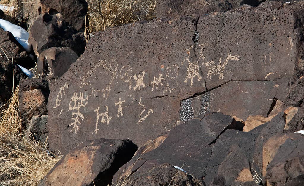
Petroglyphs National Monument
Albuquerque, New Mexico, United States
82.3 km away
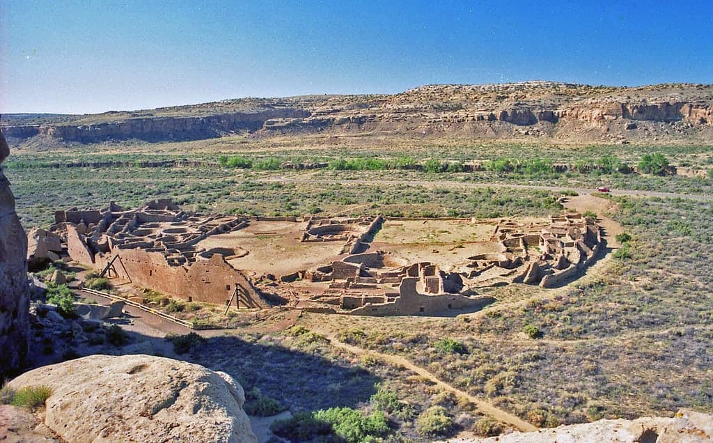
Chaco Canyon, New Mexico
San Juan County, New Mexico, United States
96.5 km away
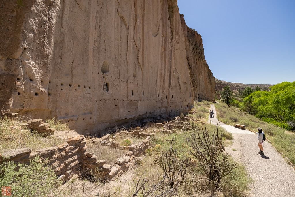
Bandelier National Monument
Sandoval County, New Mexico, United States
130.2 km away
Zuni Lake, New Mexico
Catron County, New Mexico, United States
137.6 km away