Mount San Jacinto, California
A Cahuilla cosmological axis rising two vertical miles from the desert floor to the realm of spirits
Riverside County, California, United States
At A Glance
- Coordinates
- 33.8145, -116.6792
- Suggested Duration
- The Palm Springs Aerial Tramway ride takes 10 minutes each way. The round trip summit hike from the Mountain Station is approximately 11 miles and takes 5 to 8 hours depending on pace and conditions. The Tahquitz Canyon hike takes approximately 2 hours. A combined summit and canyon day is ambitious but possible for fit hikers who start early.
- Access
- The Palm Springs Aerial Tramway departs from the Valley Station at One Tram Way, Palm Springs. The ride ascends from 2,643 feet to the Mountain Station at 8,516 feet. From there, hiking trails lead to the summit at 10,834 feet. Free wilderness permits are available at the Long Valley Ranger Station near the Mountain Station. Alternative western trailheads near Idyllwild include Marion Mountain Trail, Deer Springs Trail, and the Pacific Crest Trail junction. Tahquitz Canyon is accessed via the Visitor Center at 500 West Mesquite Avenue, Palm Springs (Agua Caliente reservation). The Santa Rosa and San Jacinto Mountains National Monument Visitor Center is in Palm Desert. Mobile phone signal is available at the tramway stations and Tahquitz Canyon Visitor Center but unreliable on summit trails and in remote canyon areas. In emergencies on the mountain, the Long Valley Ranger Station is the nearest staffed facility from the tramway side.
Pilgrim Tips
- The Palm Springs Aerial Tramway departs from the Valley Station at One Tram Way, Palm Springs. The ride ascends from 2,643 feet to the Mountain Station at 8,516 feet. From there, hiking trails lead to the summit at 10,834 feet. Free wilderness permits are available at the Long Valley Ranger Station near the Mountain Station. Alternative western trailheads near Idyllwild include Marion Mountain Trail, Deer Springs Trail, and the Pacific Crest Trail junction. Tahquitz Canyon is accessed via the Visitor Center at 500 West Mesquite Avenue, Palm Springs (Agua Caliente reservation). The Santa Rosa and San Jacinto Mountains National Monument Visitor Center is in Palm Desert. Mobile phone signal is available at the tramway stations and Tahquitz Canyon Visitor Center but unreliable on summit trails and in remote canyon areas. In emergencies on the mountain, the Long Valley Ranger Station is the nearest staffed facility from the tramway side.
- Dress for the elevation you intend to reach. The tramway ascends from desert temperatures (potentially exceeding 110 degrees Fahrenheit in summer) to mountain conditions (60 to 80 degrees in summer, below freezing in winter). Layers are essential. Sturdy hiking boots for trail use. In winter above 7,000 feet, crampons or microspikes are required. Sun protection at all elevations.
- Photography is generally permitted on state park and National Monument trails. At Tahquitz Canyon, follow posted guidelines — some cultural features may have restrictions. Do not photograph tribal ceremonies, sacred objects, or individuals without explicit permission. The summit offers extraordinary photographic opportunities, but consider spending time looking before reaching for the camera.
- A free wilderness permit is required for day hiking in the state park wilderness, available at the Long Valley Ranger Station near the tramway Mountain Station. Overnight camping requires a separate permit. The summit trail gains significant elevation, and altitude sickness can affect visitors who ascend rapidly via the tramway. Weather changes fast above the tree line, and summer afternoon thunderstorms pose a real lightning risk on the exposed summit. In winter, snow and ice require crampons or microspikes above 7,000 feet. At Tahquitz Canyon, follow all posted guidelines. This is tribal land, operated by the Agua Caliente Band. The canyon closes seasonally (typically July through September) due to extreme heat. Do not disturb archaeological features, rock art, or natural elements. Photography restrictions may apply to cultural sites within the canyon.
Overview
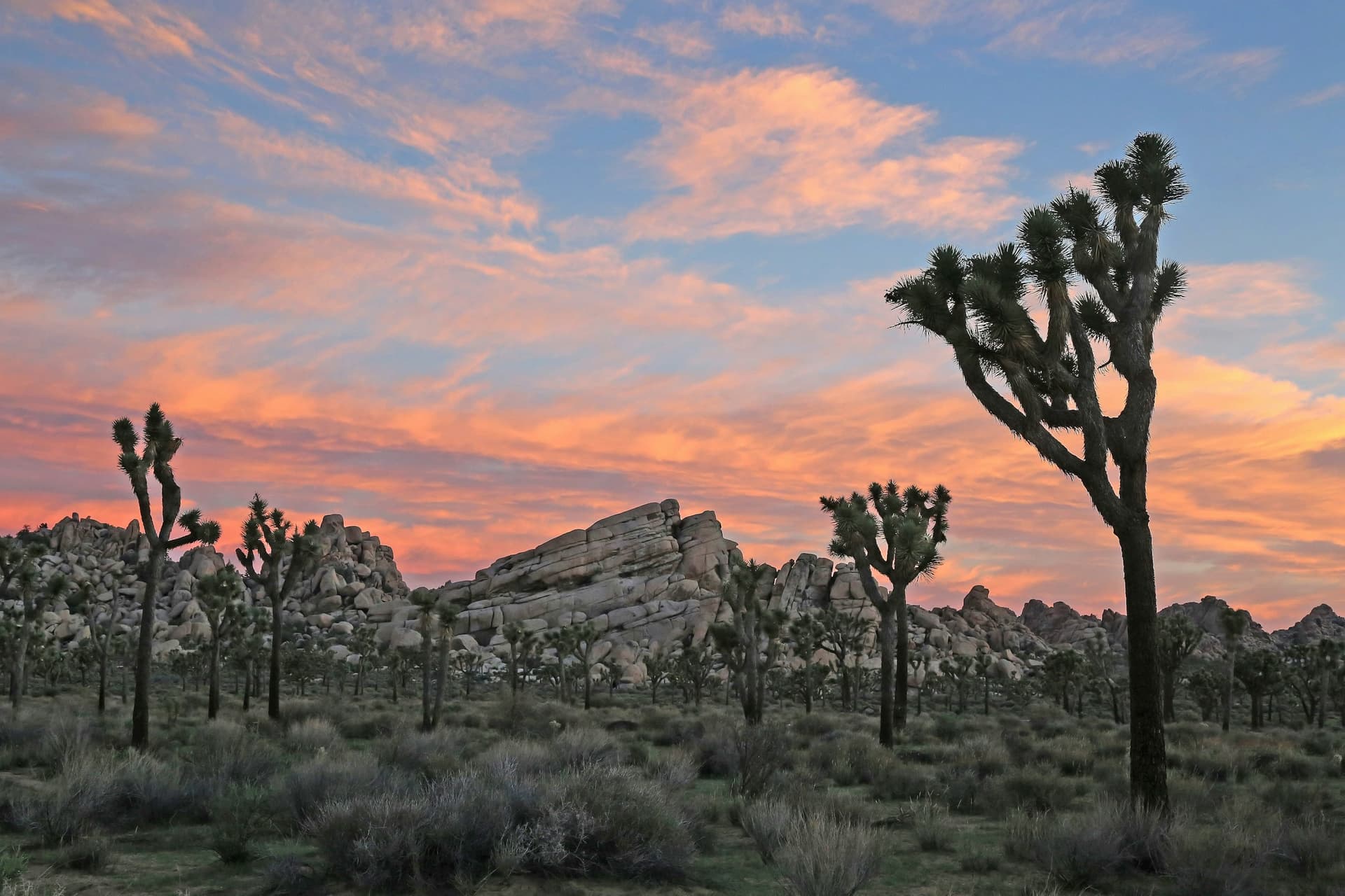
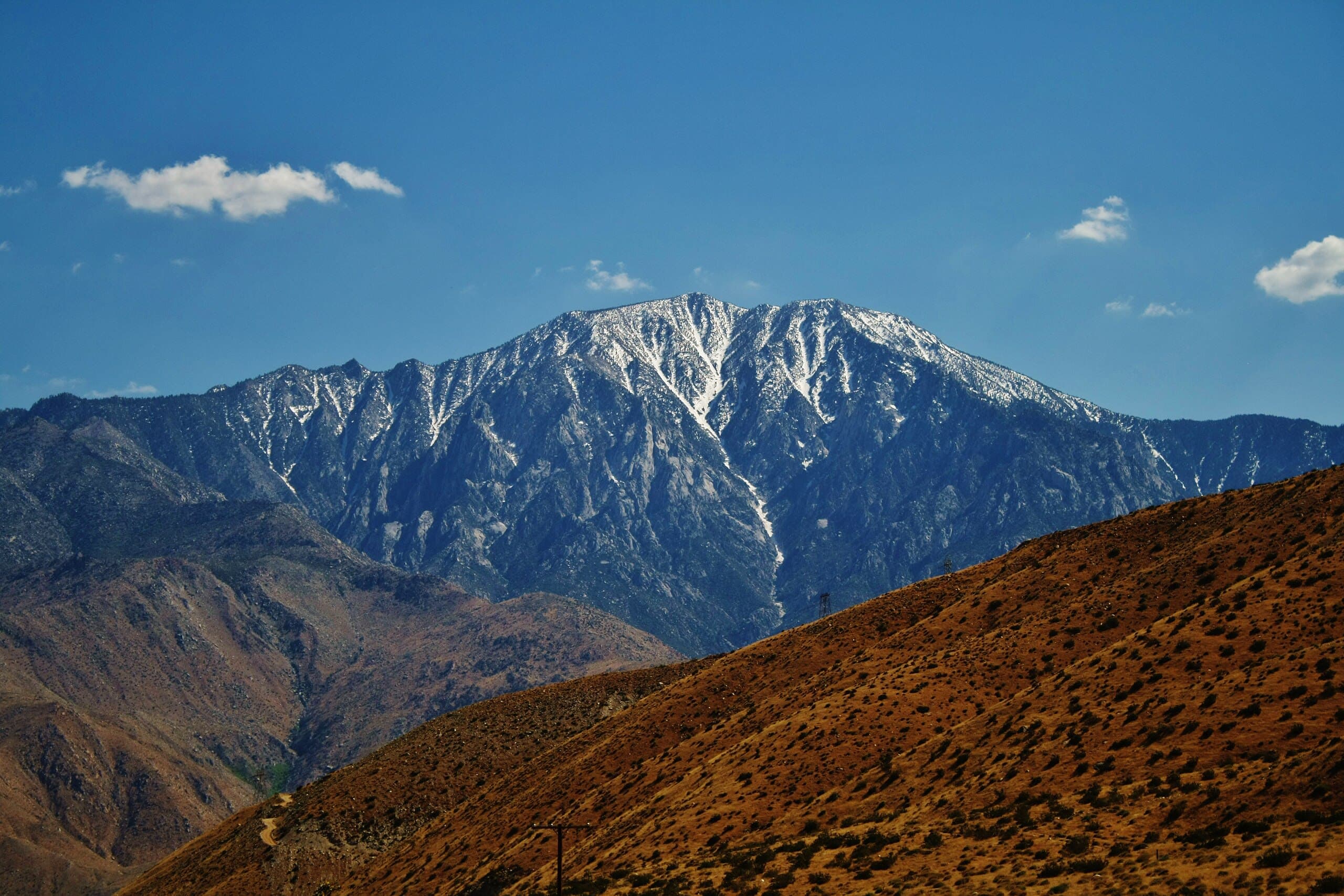
Mount San Jacinto rises nearly two vertical miles above the Sonoran desert floor outside Palm Springs, creating one of the most dramatic vertical landscapes in North America. For the Cahuilla people, whose presence here spans millennia, this mountain is not scenery. It is the axis around which their cosmology turns — created by a primordial twin, home to the founder-deity Dakush at its summit, haunted by the banished first shaman Tahquitz in its granite peaks.
The desert floor outside Palm Springs shimmers at 452 feet above sea level. Look west and the mountain simply rises — not gradually, not gently, but with a verticality that borders on the improbable. The summit of San Jacinto stands at 10,834 feet, nearly two vertical miles above the city, and the horizontal distance between them is startlingly short. Five distinct ecological zones compress into a few miles of elevation gain, from Sonoran desert cactus through chaparral, pine forest, and subalpine woodland to the bare granite summit. A journey that would normally require traveling from Mexico to Canada unfolds here in a single ascent.
The Cahuilla people, who have inhabited both sides of this mountain for at least five thousand years by archaeological record and far longer by their own reckoning, understand this vertical landscape as cosmological structure. The mountain range itself was created by Temayawet, one of two primordial twins who shaped the world. The summit is the home of Dakush, the meteor and legendary founder of the Cahuilla. The granite peaks and canyons shelter the banished spirit of Tahquitz, the first shaman, whose corrupted power manifests in earthquakes, lightning, and green fireballs seen above the ridgeline. The hot springs at the mountain's base connect to a spiritual underworld inhabited by nukatem, ancient sacred beings.
This is not background landscape with spiritual associations layered on top. In Cahuilla understanding, the mountain is the spiritual reality; the rock and trees and weather are its expression. When thunder rolls in the peaks and the granite trembles along the San Jacinto Fault, the Cahuilla explanation — Tahquitz moving in his cave — is not metaphor but description. The mountain is alive with presence, and visitors who ascend it with that awareness encounter something more than elevation gain.
Context And Lineage
Mount San Jacinto has been central to Cahuilla life for at least five thousand years by archaeological record and far longer by oral tradition. The mountain was created in the Cahuilla origin story by the primordial twin Temayawet. Its summit houses Dakush, the founder-deity. Its peaks are home to Tahquitz, the first shaman, banished for misusing his powers. The Agua Caliente Band of Cahuilla Indians co-manages the Santa Rosa and San Jacinto Mountains National Monument with federal agencies and operates cultural tourism programs at Tahquitz Canyon.
The Cahuilla creation story begins with Amnaa (Power) and Tukmiut (Night), from whose union two primordial twins were born — Mukat and Temayawet. The twins competed to shape the world. Temayawet blew into the ground and made giant rock formations emerge, creating the San Jacinto Mountain range among other landforms.
Mukat, the more orderly creator, made the first people and gave them a guardian: Tahquitz, the first puul (shaman). Mukat endowed Tahquitz with great supernatural powers to serve and protect the Cahuilla. But power corrupted. Tahquitz began using his gifts for selfish and harmful ends. The people could not tolerate his abuse and banished him to the San Jacinto Mountains, where he retreated to a cave high on the peak that now bears his name.
Tahquitz did not go quietly. From his mountain stronghold, he continues to manifest his power. Green fireballs seen above the peaks are his doing. Lightning that strikes the granite is his anger. The rumbling in the earth is his movement. The legendary Cahuilla leader Algoot confronted Tahquitz in a battle that shaped the mountain itself — the granite monoliths of Suicide Rock and Lily Rock are remnants of their clash. When Tahquitz rolled Lily Rock across the entrance to his cave, the earth shook.
The summit belongs to a different being entirely: Dakush, the meteor, legendary founder of the Cahuilla people, whose home is the highest point of the mountain. The distinction matters. Tahquitz inhabits the dramatic, violent middle elevations — the zone of lightning and earthquake. Dakush dwells at the summit, the smooth rocks above the storms.
The Cahuilla relationship with San Jacinto has persisted through every disruption that colonization imposed. Spanish missions relocated indigenous populations. Mexican land grants reorganized the landscape. American settlement brought ranching, mining, and tourism. Through each transition, the Cahuilla maintained their connection to the mountain.
The modern chapter of this lineage includes the establishment of the state park in 1937, the opening of the tramway in 1963, and — most significantly — the designation of the Santa Rosa and San Jacinto Mountains National Monument in 2000 with its co-management structure. The Agua Caliente Band of Cahuilla Indians now exercises formal stewardship over the mountain landscape alongside federal agencies. At Tahquitz Canyon, the Cahuilla operate their own visitor center, hire their own rangers, and tell their own story. The mountain's lineage of meaning has not been interrupted. It has been contested, constrained, and partially reclaimed.
Mukat
deity
Creator deity, one of the twin primordial beings who shaped the world. Mukat created the first people and established Tahquitz as the first shaman. His creative acts established the order of Cahuilla existence.
Temayawet
deity
The rival twin of Mukat who blew into the ground and raised the San Jacinto Mountain range as giant rock formations. His creative power shaped the physical landscape that the Cahuilla would inhabit.
Tahquitz
spiritual
The first shaman, created by Mukat and given great supernatural powers. He used those powers for evil and was banished to the San Jacinto Mountains, where his spirit inhabits the peaks. He manifests as lightning, green fireballs, meteors, and seismic trembling. His legend is shared across Cahuilla, Kumeyaay, and Luiseno traditions.
Dakush
deity
The meteor and legendary founder of the Cahuilla people, whose home is the summit of San Jacinto. While Tahquitz haunts the storm-zone of the middle peaks, Dakush dwells at the summit above the weather.
Algoot
historical
A legendary Cahuilla leader who fought Tahquitz in a battle that shaped the mountain's granite formations. The monoliths of Suicide Rock and Lily Rock are remnants of their confrontation.
Why This Place Is Sacred
Mount San Jacinto's thinness arises from the extreme compression of worlds within a single landscape. The mountain's vertical drama — nearly 10,400 feet of elevation gain in a few horizontal miles — creates a physical experience of traveling between realms. For the Cahuilla, this vertical axis connects the desert floor, the canyons with their hot springs linking to the underworld, the forests where seasonal life unfolded, and the summit where Dakush dwells. The mountain generates its own weather, trembles with seismic energy, and harbors a banished spirit whose presence is felt in lightning and stone.
Most sacred mountains are sacred at the summit. San Jacinto is sacred from bottom to top, and the thinness is distributed across elevation — each zone holds its own kind of significance.
At the base, the desert floor meets the mountain's foot with an abruptness that has no equivalent in most mountain landscapes. The hot springs that emerge here — heated by the same tectonic forces that raised the mountain — were understood by the Cahuilla as connection points to the spiritual underworld, portals where the nukatem, ancient sacred beings, could be accessed. The springs are not an amenity. They are a theological fact.
As elevation increases, the desert gives way to chaparral, then oak woodland, then dense pine and fir forest. The Cahuilla traveled this gradient seasonally, hunting deer at higher elevations in summer, gathering pinon nuts and acorns in autumn, retreating to the warmer desert in winter. The seasonal migration was not merely practical but cosmological — a lived experience of moving between the layers of a vertically structured world.
Above the tree line, the granite monoliths begin. Tahquitz Peak, Lily Rock, Suicide Rock — the names carry the legend. In Cahuilla tradition, these formations are remnants of the battle between the leader Algoot and the banished shaman Tahquitz. When Tahquitz rolled Lily Rock across the entrance to his cave, the earth quaked. The San Jacinto Fault runs directly beneath the mountain, and seismic activity is a regular feature of the landscape. The geological and the mythological describe the same phenomenon in different vocabularies.
At the summit, granite slabs worn smooth by wind and ice — Aya Kaich, smooth rocks, in the Cahuilla language — open to a view that encompasses the Salton Sea to the east and, on clear days, the Pacific Ocean to the west. The perspective is disorienting in its scope. Standing here, you see the curvature of the world. The thinness at the summit is the thinness of altitude itself — the air literally thinner, the sky a deeper blue, the silence of a place where few living things persist.
The mountain also generates its own weather. Storms form around the summit when the surrounding desert is still clear. Lightning strikes the peaks. Thunder rolls down the canyons. The Cahuilla attribute these phenomena to Tahquitz, whose presence in the mountain is not historical but ongoing. Visitors who have watched green light moving along the ridgeline, or heard rumbling with no meteorological explanation, understand why the Cahuilla do not speak of Tahquitz in the past tense.
In Cahuilla cosmology, the San Jacinto Mountain range was not built for a purpose — it is the purpose. The mountains were created in the primordial act of world-making by Temayawet, one of two rival twins born from the union of lightning, night, and power. The mountain's existence is coterminous with the existence of the Cahuilla world itself. Its summit houses Dakush, the meteor-deity and legendary founder of the Cahuilla people. Its slopes and canyons provided the ecological foundation for Cahuilla life — game, acorns, pinon nuts, medicinal plants, water. The mountain is simultaneously cosmological origin, spiritual dwelling, and practical sustenance. These categories, distinct in Western thinking, are unified in the Cahuilla relationship with San Jacinto.
The Cahuilla relationship with San Jacinto was disrupted but not severed by colonization. The first European to sight the mountain was Captain Juan Bautista de Anza in 1774. Spanish missions, Mexican ranchos, and American settlement progressively restricted Cahuilla access to their traditional territories. Yet the Agua Caliente Band of Cahuilla Indians maintained their presence in the area, and the mountain's significance persisted through every disruption.
In 1937, Mount San Jacinto State Park was established, preserving 14,000 acres of the upper mountain. In 1963, the Palm Springs Aerial Tramway opened, transforming the mountain from a challenging multi-day climb into a ten-minute ride — democratizing access while also creating new pressures on the landscape. In 2000, Congress designated the Santa Rosa and San Jacinto Mountains National Monument, with a co-management structure that includes the Agua Caliente Band alongside the BLM and Forest Service.
This co-management represents something significant: official recognition that the Cahuilla relationship with the mountain carries authority equal to federal land management. The Agua Caliente Band operates the Tahquitz Canyon Visitor Center, where the Cahuilla tell their own story to visitors on their own terms. The mountain's trajectory is unusual among American sacred sites — from indigenous cosmological center to colonial disruption to a modern arrangement where indigenous stewardship has formal standing.
Traditions And Practice
The Cahuilla maintain active cultural stewardship of Mount San Jacinto through co-management of the National Monument and operation of cultural tourism programs at Tahquitz Canyon. Specific ceremonial practices are private. Visitors can engage with the mountain's cultural depth through the tribally operated Tahquitz Canyon experience and through approaching the summit with awareness of its cosmological significance.
The Cahuilla practiced seasonal migration across the mountain's elevation gradient, moving from the warm desert floor in winter to the cooler mountain forests in summer. This migration was not merely practical but reflected a cosmological relationship with the vertical landscape — each elevation zone carried its own significance and provided its own resources. Acorns and pinon nuts were gathered at middle elevations. Deer were hunted in the forests. Medicinal plants grew at specific altitudes.
The hot springs at the mountain's base held particular ceremonial significance as connection points to the spiritual underworld, where the nukatem — ancient sacred beings — could be accessed. Shamanistic traditions were connected to Tahquitz, who despite his banishment remained the guardian spirit of all shamans. Elaborate ceremonies marked every important milestone in Cahuilla life, embedded within the mountain landscape that formed the axis of their world.
The Agua Caliente Band of Cahuilla Indians operates Tahquitz Canyon as a tribally managed cultural and ecological site. The Visitor Center features exhibits, artifacts, and a film about the Legend of Tahquitz, presenting the Cahuilla narrative in the Cahuilla's own voice. Rangers employed by the tribe manage the canyon trail and interpret the landscape for visitors.
The co-management of the National Monument represents a form of ongoing practice — the exercise of cultural sovereignty over sacred landscape through formal governmental structures. The Cahuilla are not consultants to federal land management; they are co-managers, with authority that reflects their relationship with the mountain.
Specific ceremonial practices maintained by the Cahuilla community are private, as is appropriate for sacred traditions that continue in living practice.
The mountain rewards visitors who ascend with awareness of where they are — not just geographically but cosmologically.
At Tahquitz Canyon, begin at the Visitor Center and absorb the Legend of Tahquitz before walking the trail. The canyon's atmosphere — the narrowing walls, the shifting light, the sound of water — corresponds to the legend's description of Tahquitz's domain. Walk slowly. The trail is not long, and rushing through it misses the point.
On the summit trail, notice the ecological transitions as you climb. Each zone is distinct: the pine forest gives way to denser fir, then to sparse, wind-bent trees, then to bare granite. The Cahuilla lived within these transitions seasonally, knowing each zone intimately. At the summit, sit on the smooth granite and take in the view. The Salton Sea, the desert floor where the temperature may be forty degrees warmer than where you sit, the distant coast — the mountain holds all of this in its vertical embrace.
If you experience a storm on the mountain — and storms arrive quickly, especially in summer afternoons — you will understand the Tahquitz legend in your body. The thunder does not merely echo in the peaks. It seems to originate from within them.
Cahuilla
ActiveMount San Jacinto is the cosmological axis of Cahuilla existence. The mountain range was created by the primordial twin Temayawet in the origin of the world. The summit is the home of Dakush, the meteor and legendary founder of the Cahuilla people. The peaks and canyons shelter the spirit of Tahquitz, the first shaman, banished for misusing his powers. The hot springs at the base connect to the spiritual underworld. The Cahuilla lived within this vertical cosmology for millennia, migrating seasonally between desert floor and mountain forest.
The Agua Caliente Band of Cahuilla Indians co-manages the Santa Rosa and San Jacinto Mountains National Monument and operates cultural tourism programs at Tahquitz Canyon, where the Cahuilla story is told on Cahuilla terms. Traditional practices included seasonal migration across elevation zones, ceremonial use of hot springs as connections to the spiritual underworld, and shamanistic traditions connected to Tahquitz. Contemporary ceremonial practices are maintained privately within the Cahuilla community.
Kumeyaay and Luiseno
HistoricalThe Kumeyaay and Luiseno peoples, neighbors of the Cahuilla, share traditions about the Tahquitz spirit associated with the San Jacinto Mountains. The cross-cultural persistence of the Tahquitz legend across three distinct peoples suggests deep antiquity and broad regional significance. In all three traditions, Tahquitz represents supernatural power that has been corrupted — a cautionary figure whose presence in the mountain carries moral weight.
No publicly documented active Kumeyaay or Luiseno ceremonial practices specific to Mount San Jacinto. The shared Tahquitz tradition suggests historical interaction with the mountain across multiple indigenous groups.
Conservation and Co-Management
ActiveThe Santa Rosa and San Jacinto Mountains National Monument, designated by Congress in 2000, represents a formal partnership between federal agencies and the Agua Caliente Band of Cahuilla Indians. The co-management structure gives the Cahuilla formal authority over cultural sites and resources within the monument, creating a model cited in land management literature for indigenous-federal collaboration.
Joint management planning between the BLM, Forest Service, and Agua Caliente Band. Tribal operation of Tahquitz Canyon as a cultural and ecological site. Protection of archaeological resources including village sites, rock art, and shell middens. Habitat management for endangered peninsular bighorn sheep and other species across the mountain's elevation gradient.
Experience And Perspectives
Mount San Jacinto offers a physically dramatic experience of ascent — from Sonoran desert to alpine summit through five ecological zones. The Palm Springs Aerial Tramway compresses this transition into ten minutes, creating a visceral sense of traveling between worlds. Summit hikers encounter granite, silence, and a perspective that spans desert to ocean. Tahquitz Canyon, on the mountain's lower slopes, provides a tribally managed encounter with the Cahuilla landscape and its legends.
The tramway cabin lifts from the desert floor and the world begins to change. Within the first minutes, the Sonoran landscape — creosote bush, barrel cactus, ocotillo — falls away beneath you. Chaparral appears. Then the first pines. By the time the cabin reaches the Mountain Station at 8,516 feet, you have left the desert entirely. The air is twenty to thirty degrees cooler. The scent of Jeffrey pine fills the station platform. If there is snow, it begins at your feet.
This transition is the experience. Not a metaphor for crossing between worlds, but a physical version of it — the five life zones that the mountain compresses into its flanks creating a sensory journey from one climate, one ecosystem, one quality of light and air into another. The Cahuilla traveled this gradient on foot over the course of seasons. The tramway delivers it in ten minutes, and the speed makes the contrast sharper, not duller.
From the Mountain Station, trails lead through subalpine forest toward the summit. The Round Valley Trail passes through a meadow ringed by lodgepole pines where mule deer graze in early morning. The summit trail gains elevation steadily through increasingly sparse forest until the trees give way to granite. The final approach crosses bare rock slabs — Aya Kaich, the smooth rocks — where footing demands attention and the wind can arrive without warning.
The summit view repays every step. On clear days, the Salton Sea glimmers to the east, a geographical oddity two hundred feet below sea level. To the west, the ridgeline of the San Jacinto range falls away toward the coastal valleys, and on the clearest days the Pacific Ocean is visible. The desert stretches north and south. You are standing on a point that can see most of Southern California, and the perspective it provides is not just visual but temporal — this mountain has been here, in approximately its current form, for the entirety of human presence in the region.
Tahquitz Canyon, on the mountain's eastern base, offers a different quality of encounter. Operated by the Agua Caliente Band of Cahuilla Indians, the canyon requires paid admission and begins at a visitor center where a film tells the Legend of Tahquitz. The trail follows a creek through a narrow canyon to a seasonal waterfall. The stone walls close in. The light changes. If you have absorbed the legend before entering — the banished shaman, the corrupted power, the cave sealed by a rolling boulder — the canyon's atmosphere takes on a weight that goes beyond geology.
Two approaches offer distinct experiences, and visitors seeking the mountain's full depth should consider both.
For the summit, take the Palm Springs Aerial Tramway and hike the 5.5-mile trail to San Jacinto Peak. Pick up a free wilderness permit at the Long Valley Ranger Station. Start early. The trail is not technically difficult but gains 2,300 feet from the tramway station, and altitude affects some visitors. At the summit, spend time with the view before descending. Let the scale of what you can see settle. The Cahuilla name for this place — smooth rocks — is precise. Feel the granite under your hands.
For Tahquitz Canyon, begin at the Visitor Center on Mesquite Avenue in Palm Springs. Watch the film. Read the exhibits. Then walk the canyon trail with the legend in mind. The canyon is not long — perhaps two miles round trip — but its atmosphere is concentrated. The waterfall, when flowing, marks the trail's turning point. This is a Cahuilla place, managed by Cahuilla people. Let that frame your experience.
The two visits — summit and canyon — correspond roughly to the Cahuilla cosmological axis. The summit is the realm of Dakush, the founder-deity. The canyon is the domain of Tahquitz, the banished shaman. Between them, the mountain's full spiritual geography becomes legible.
Mount San Jacinto invites interpretation from geological, ecological, cultural, and spiritual vantage points. The scholarly, indigenous, and alternative perspectives each illuminate different dimensions of the mountain, but honest engagement requires recognizing that the Cahuilla understanding is not one interpretation among many — it is the perspective of the people who have lived with this mountain as their cosmological center for thousands of years.
Archaeological research documents Cahuilla habitation in the San Jacinto Mountains area for at least five thousand years, with Tahquitz Canyon yielding some of the richest evidence. The creation narratives connecting the mountain range to the primordial twin Temayawet are documented in multiple ethnographic sources, with some variation across Cahuilla bands in naming and detail. The Tahquitz legend is one of the most extensively recorded Native American supernatural traditions in Southern California, appearing across Cahuilla, Kumeyaay, and Luiseno cultures — a cross-cultural consistency that suggests deep antiquity.
Geologically, the San Jacinto Mountains are part of the Peninsular Ranges, formed by tectonic activity along the San Jacinto Fault. The mountain's dramatic verticality is a product of active faulting — the same forces that produce the earthquakes the Cahuilla attribute to Tahquitz. The convergence of geological explanation and mythological narrative at this site is particularly striking: both describe a mountain that shakes, a subterranean force that manifests at the surface.
The co-management of the National Monument by the Agua Caliente Band with federal agencies is cited in land management literature as a model for collaborative stewardship between tribal nations and the U.S. government.
For the Cahuilla, Mount San Jacinto is not a sacred site within their territory. It is the cosmological axis around which their territory, identity, and spiritual life are organized. The mountain was created in the origin of the world. Its summit houses their founder-deity. Its peaks contain a powerful and dangerous spiritual being. Its canyons and slopes provided the ecological foundation for Cahuilla life across millennia.
The Agua Caliente Band exercises this understanding through formal co-management of the National Monument and through the Tahquitz Canyon cultural tourism program, where the Cahuilla tell their own story in their own words. The specific ceremonial practices maintained on and around the mountain are not public knowledge, and that privacy is itself an expression of the tradition's vitality — sacred knowledge is protected precisely because it is still active, still powerful, still practiced.
Some New Age and spiritual tourism sources describe the San Jacinto area, particularly the town of Idyllwild, as having special energy or vortex properties. The mountain's dramatic physical characteristics — the extreme elevation, the ecological transitions, the seismic activity — invite such characterizations. While the mountain's qualities are real, these framings tend to detach the site from its Cahuilla cultural foundation, treating the felt power of the place as a generic resource available for individual consumption rather than as a dimension of a specific people's living relationship with their cosmological center.
The full archaeological record of the summit and upper slopes remains incompletely surveyed. The complete Cahuilla cosmological system connecting San Jacinto to other sacred mountains and sites has not been fully documented in public sources — by design, as much of this knowledge is maintained within the community. The nature of the mysterious green fireballs and rumbling sounds attributed to Tahquitz correlates intriguingly with seismic activity on the San Jacinto Fault and possible atmospheric phenomena, but no systematic study has connected the reported phenomena to specific geological events. Whether additional indigenous traditions about the mountain exist beyond the Cahuilla, Kumeyaay, and Luiseno accounts remains an open question.
Visit Planning
Mount San Jacinto is accessible via the Palm Springs Aerial Tramway, which ascends 6,000 feet in ten minutes, or via hiking trailheads on the western side near Idyllwild. A free wilderness permit is required for state park hiking. Tahquitz Canyon, on the eastern base, requires paid admission through the Agua Caliente tribal visitor center. Conditions vary dramatically with elevation and season.
The Palm Springs Aerial Tramway departs from the Valley Station at One Tram Way, Palm Springs. The ride ascends from 2,643 feet to the Mountain Station at 8,516 feet. From there, hiking trails lead to the summit at 10,834 feet. Free wilderness permits are available at the Long Valley Ranger Station near the Mountain Station. Alternative western trailheads near Idyllwild include Marion Mountain Trail, Deer Springs Trail, and the Pacific Crest Trail junction. Tahquitz Canyon is accessed via the Visitor Center at 500 West Mesquite Avenue, Palm Springs (Agua Caliente reservation). The Santa Rosa and San Jacinto Mountains National Monument Visitor Center is in Palm Desert. Mobile phone signal is available at the tramway stations and Tahquitz Canyon Visitor Center but unreliable on summit trails and in remote canyon areas. In emergencies on the mountain, the Long Valley Ranger Station is the nearest staffed facility from the tramway side.
Palm Springs offers extensive lodging at all price points. The tramway's Mountain Station has a restaurant but no overnight accommodations. Primitive camping within the state park wilderness requires a permit. The town of Idyllwild, on the mountain's western slopes, offers lodging with proximity to western-approach trailheads and views of Tahquitz Peak and Lily Rock. No accommodations exist at Tahquitz Canyon.
Mount San Jacinto requires respect at two levels: the practical respect appropriate to a wilderness area with serious terrain and weather, and the cultural respect appropriate to a mountain that is a cosmological axis for a living people. At Tahquitz Canyon, you are on tribal land and should follow all posted guidelines without exception.
The mountain's dual identity — public recreational land and Cahuilla sacred landscape — requires visitors to hold both realities simultaneously. The state park trails are open and welcoming, but the landscape they traverse carries meanings that predate the park by thousands of years. Hiking here with awareness of the Cahuilla cosmology does not require special behavior beyond ordinary trail courtesy, but it transforms the experience from recreation to something closer to pilgrimage.
Tahquitz Canyon operates under different rules because it is tribal land. The Agua Caliente Band has opened their canyon to visitors on their terms, which includes paid admission, ranger supervision, and specific guidelines about behavior and photography. Follow these without negotiation. The canyon's accessibility to non-Cahuilla visitors is a generosity, not a right.
Throughout the mountain, do not disturb archaeological sites, rock art, or cultural features. The San Jacinto landscape is rich in evidence of human habitation — shell middens, rock shelters, lithic scatters — much of it not marked or interpreted. If you encounter such features, observe without touching and report them to park rangers.
Dress for the elevation you intend to reach. The tramway ascends from desert temperatures (potentially exceeding 110 degrees Fahrenheit in summer) to mountain conditions (60 to 80 degrees in summer, below freezing in winter). Layers are essential. Sturdy hiking boots for trail use. In winter above 7,000 feet, crampons or microspikes are required. Sun protection at all elevations.
Photography is generally permitted on state park and National Monument trails. At Tahquitz Canyon, follow posted guidelines — some cultural features may have restrictions. Do not photograph tribal ceremonies, sacred objects, or individuals without explicit permission. The summit offers extraordinary photographic opportunities, but consider spending time looking before reaching for the camera.
Do not leave offerings or objects on the mountain. If you wish to express something, do it internally. The mountain does not need your objects; it needs your attention.
Free wilderness permit required for day hiking in the state park wilderness. Paid admission at Tahquitz Canyon (operated by the Agua Caliente Band). Camping permit required for overnight stays. Stay on designated trails. No collecting plants, rocks, or artifacts. Some areas within the National Monument may have tribal access restrictions not posted at trailheads — respect any signage or ranger guidance encountered.
Sacred Cluster
Nearby sacred places create the location cluster described in the growth plan. This block is intentionally crawlable and links into the wider regional graph.