UNESCOPre-Pottery Neolithic
Göbekli Tepe
Haliliye, Şanlıurfa, Turkey
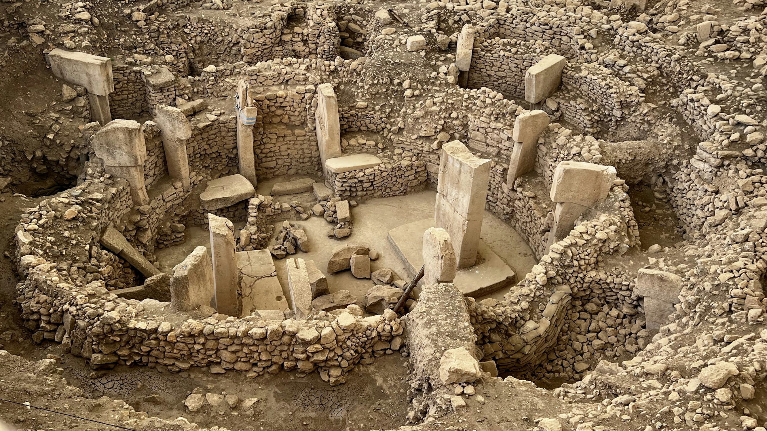
Göbekli Tepe is a neolithic archaeological site of sacred significance. Approximate coordinates: 37.22318, 38.92248. Attributes: built, cultural, archaeological, ceremonial. Tradition: Pre-Pottery Neolithic. Recognized as a UNESCO World Heritage Site. Göbekli Tepe (Turkish: [ɟœbecˈli teˈpe], Potbelly Hill ; Kurdish: Girê Mirazan or Xerabreşkê, Wish Hill ) is a Neolithic archaeological site in Upper Mesopotamia (al-Jazira) in modern-day Turkey. The settlement was inhabited from around 9500 BCE to at least 8000 BCE, during the Pre-Pottery Neolithic. It is famous for its large circular structures that contain massive stone pillars – among the world s oldest known megaliths. Many of these pillars are decorated with anthropomorphic details, clothing, and sculptural reliefs of wild animals, providing archaeologists rare insights into prehistoric religion and the particular iconography of the period. The 15 m (50 ft) high, 8 ha (20-acre) tell is densely covered with ancient domestic structures and other small buildings, quarries, and stone-cut cisterns from the Neolithic, as well as some traces of activity from later periods. The site was first used at the dawn of the southwest Asian Neolithic period, which marked the appearance of the oldest permanent human settlements anywhere in the world. Prehistorians link this Neolithic Revolution to the advent of agriculture but disagree on whether farming caused people to settle down or vice versa. Göbekli Tepe, a monumental complex built on a rocky mountaintop with no clear evidence of agricultural cultivation, has played a prominent role in this debate. Recent findings suggest a settlement at Göbekli Tepe, with domestic structures, extensive cereal processing, a water supply, and tools associated with daily life. This contrasts with a previous interpretation of the site as a sanctuary used by nomads, with few or no permanent inhabitants. No definitive purpose has been determined for the megalithic structures, which have been popularly described as the world s first temple[s] . They were likely roofed and appear to have regularly collapsed, been inundated by slope slides, and subsequently repaired or rebuilt. The architecture and iconography are similar to other contemporary sites in the vicinity, such as Karahan Tepe. The site was first noted in a 1963 archaeological survey. German archaeologist Klaus Schmidt recognised its significance in 1994 and began excavations there the following year. After he died in 2014, work continued as a joint project of Istanbul University, Şanlıurfa Museum, and the German Archaeological Institute, under the direction of Turkish prehistorian Necmi Karul. Göbekli Tepe was designated a UNESCO World Heritage Site in 2018, recognising its outstanding universal value as one of the first manifestations of human-made monumental architecture . As of 2021, around 10% of the site has been excavated. Additional areas were examined by geophysical surveys, which showed the mound to contain at least 20 large enclosures. Located in Haliliye, Güneydoğu Anadolu Bölgesi, Turkey.