Backies Broch
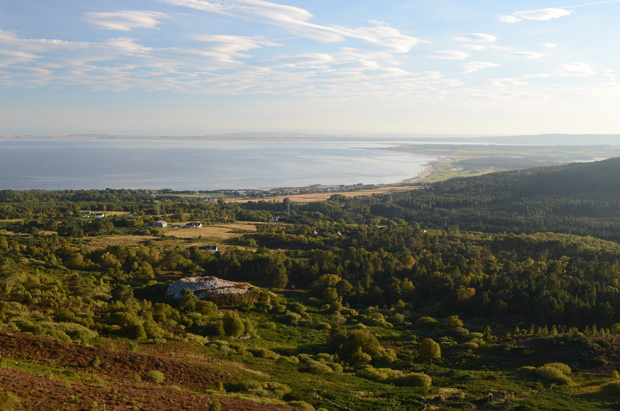
A hilltop broch above Golspie commanding panoramic views of the Moray Firth, standing quietly where few visitors venture
Golspie, Sutherland, United Kingdom
At A Glance
- Coordinates
- 57.9999, -3.9704
- Suggested Duration
- Ninety minutes to explore thoroughly and enjoy the views.
- Access
- From the A9, follow the minor road signed to Backies approximately one kilometre north of Golspie. Continue for 2.5 km to the Scottish Water Treatment Works sign. Park on the verge. Walk 80 metres up the road, take the track east to a ruined croft. Cross open ground to the broch on the hilltop. Grid reference: NC 8327 0205. No public transport to the site. Not accessible to wheelchairs.
Pilgrim Tips
- From the A9, follow the minor road signed to Backies approximately one kilometre north of Golspie. Continue for 2.5 km to the Scottish Water Treatment Works sign. Park on the verge. Walk 80 metres up the road, take the track east to a ruined croft. Cross open ground to the broch on the hilltop. Grid reference: NC 8327 0205. No public transport to the site. Not accessible to wheelchairs.
- No specific requirements beyond practical outdoor clothing. Sturdy footwear essential for the rough approach. Wind-resistant layers advisable.
- Photography is unrestricted. The entrance passage, interior scarcement ledge, and panoramic views are particularly rewarding.
- The terrain is rough and can be uneven. The broch walls, while substantial, include sections that are deteriorating. Do not climb on walls or disturb stonework. The site has no facilities.
Overview
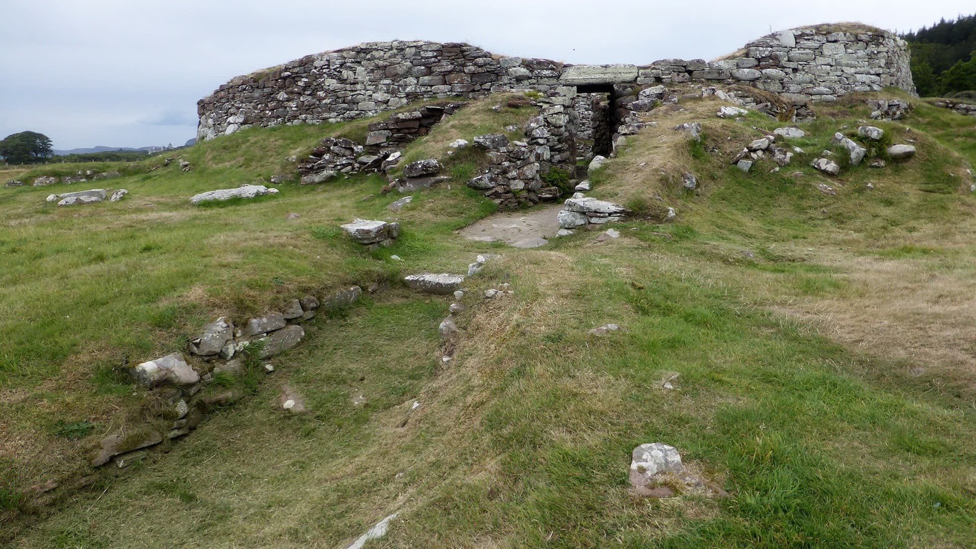
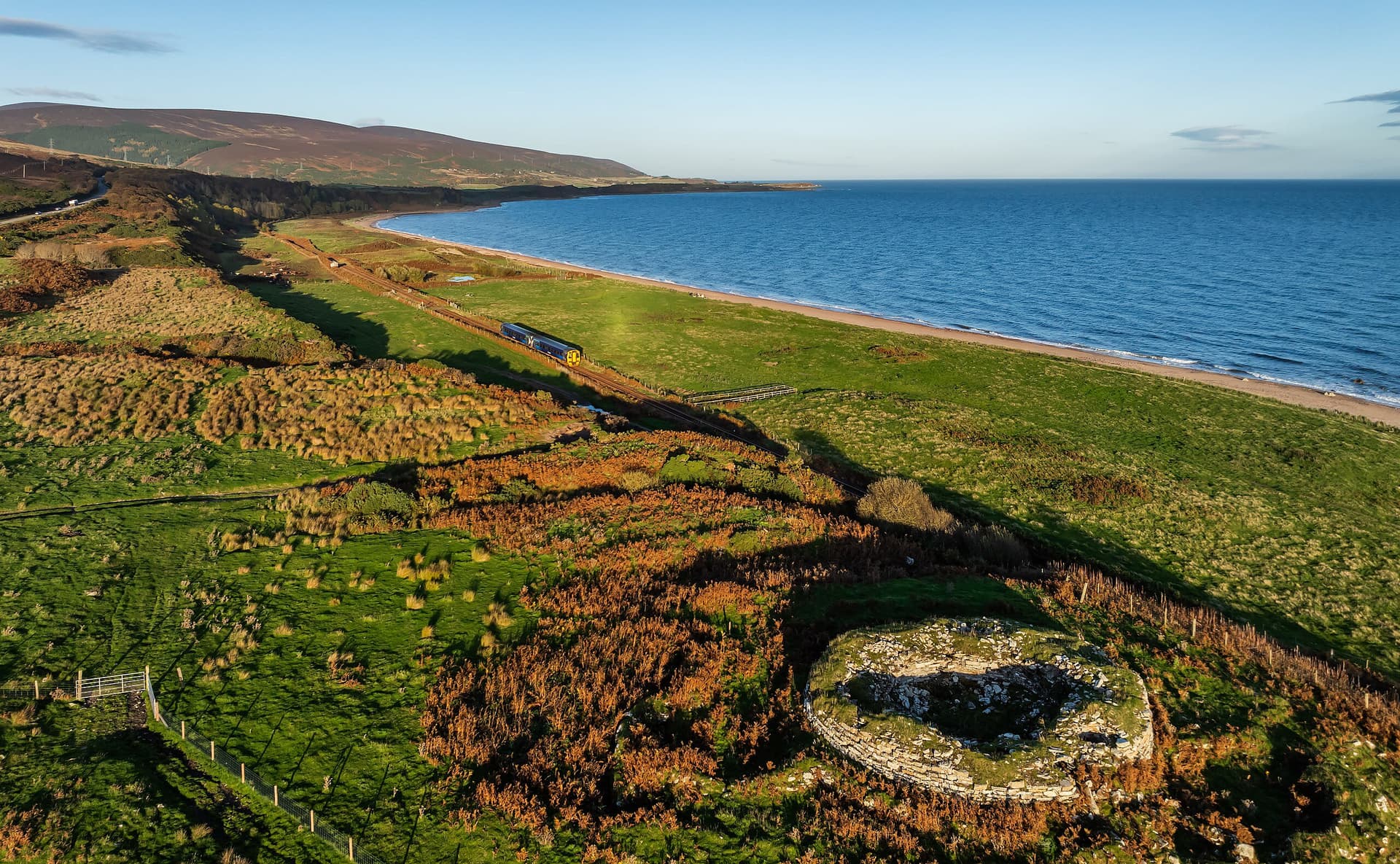
On a rocky hillock above the village of Golspie, the remains of Backies Broch look out over the Moray Firth and the North Sea. Built during the Iron Age, probably between the first century BCE and the second century CE, the broch once stood as a substantial tower-house, its double walls rising high above the surrounding farmland. Today, the walls survive to approximately two and a half metres, the entrance passage retains its original lintel stones, and a scarcement ledge still projects from the interior wall where it once supported an upper wooden floor. This is not a famous monument. Visitors are rare. That scarcity of attention is part of what makes the experience rewarding.
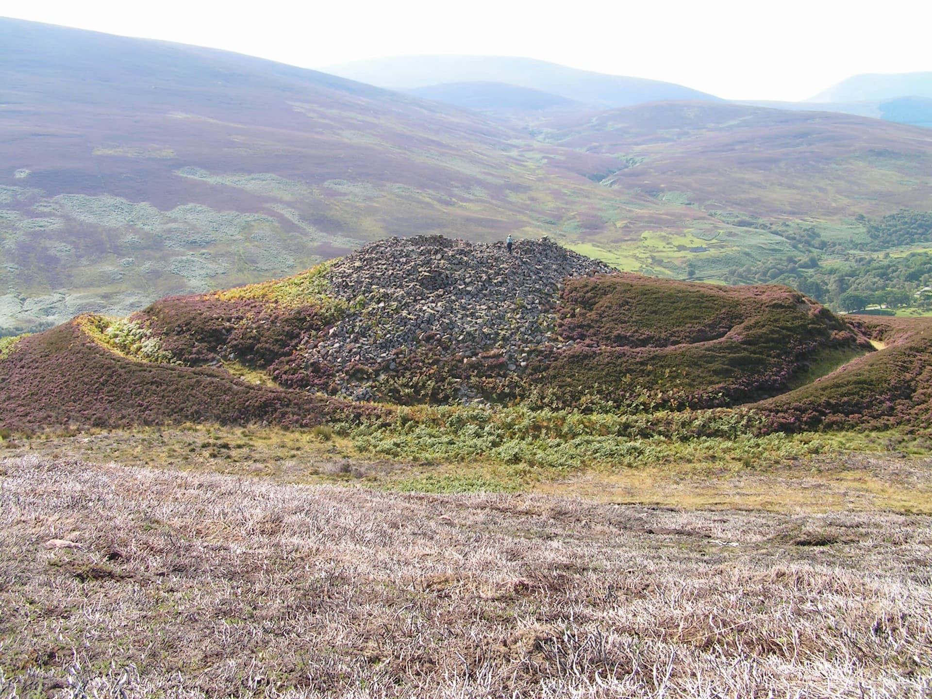
Backies Broch earns its visitors in a modest way. From the minor road north of Golspie, the walk involves following a track past a water treatment works and then a path through farmland to the rocky hilltop. The broch does not announce itself from a distance. It appears as a mound of stone, its profile merging with the hillock on which it sits. Only when you climb up and look into the interior does its true nature become clear.
The construction is impressive for its age and setting. The walls, built from fine flat slabs of metamorphosed sandstone laid in courses so regular they have been described as brick-like, demonstrate a level of masonry skill that remains striking two thousand years later. The entrance passage on the southeast side is still roofed with its original lintel stones, creating a low, dark corridor that connects the exterior world to the protected interior. A mural chamber opens off the passage, and the remains of a stair gallery indicate that the tower originally rose to a considerable height.
The broch was excavated in 1846 by the Duke of Sutherland's factor, and the Danish archaeologist J. J. Worsaae, a pioneering figure in European archaeology, sketched the exposed structure during his tour of Scotland that same year. Worsaae's drawings record features that have since deteriorated, including three lintelled voids above the doorway. The finds, deposited in Dunrobin Castle Museum, include pottery sherds, shale rings and ornaments, a jet armlet fragment, and a shale bead. These objects speak to domestic life and personal adornment rather than to overtly ritual activity.
What makes Backies Broch worth seeking out is the combination of its hilltop setting, its relative obscurity, and the quality of what survives. The panoramic views from the site extend across the Moray Firth, along the Sutherland coast, and inland toward the mountains. The broch sits between earth, sea, and sky, a liminal position that may have had cosmological significance for its builders and certainly has atmospheric resonance for modern visitors.
Context And Lineage
Backies Broch belongs to the dense concentration of Iron Age brochs along the east coast of Sutherland. The broch-building tradition, unique to Scotland, produced over five hundred such structures between approximately 400 BCE and 200 CE. Backies is a significant example, with well-preserved architectural features and a dramatic hilltop setting.
No origin narrative survives. The name Backies derives from the nearby township. Like many brochs, the site was historically associated with the Picts, though modern archaeology places its construction several centuries before the historical Pictish period.
No continuous practice connects the present to the broch's Iron Age community. The structure was excavated in 1846, and its finds were deposited in Dunrobin Castle Museum. The broch was re-scheduled as a protected monument in 2016.
J. J. Worsaae
Why This Place Is Sacred
Backies Broch derives its contemplative quality from elevation, solitude, and the surprise of discovery. The hilltop position creates a natural sense of threshold, a separation from the settled world below. The relative anonymity of the site means that visitors arrive through their own initiative rather than through tourist infrastructure, creating a more personal encounter.
The walk to Backies Broch involves a gradual ascent from the ordinary landscape of farmland and roads into something older and more exposed. The hillock on which the broch sits is a natural defensive position, chosen by the Iron Age builders for the same qualities that make it atmospherically compelling today: elevation, openness to the sky, and a commanding view of the surrounding landscape.
Standing within the broch walls, the contrast between the contained interior and the vast panorama visible from the raised ramparts creates a tension characteristic of thin places. Inside, the space is enclosed, intimate, human-scale. The stones are close. The entrance passage, still roofed, provides only a narrow connection to the outside. Step up onto the rampart, and the world opens: the Moray Firth stretching toward the horizon, the coast of Sutherland receding north and south, the mountains visible inland on clear days.
The broch's condition contributes to the effect. This is not a restored or reconstructed monument. It is a ruin in the honest sense, its deterioration since the 1846 excavation visible in the progressive loss of features that Worsaae recorded but which time has taken. This quality of impermanence within permanence, the ongoing loss within the enduring presence, invites reflection on the relationship between building and decay, intention and entropy.
The solitude is perhaps the most significant factor. Backies Broch has no information boards, no car park, no formal path. To find it requires either local knowledge or careful map reading. This means that nearly every visit is a solitary one, and solitude at a site of great age and beauty creates conditions for contemplation that cannot be manufactured.
Backies Broch functioned as a fortified dwelling for an Iron Age farming community. The thick walls, single narrow entrance, and commanding hilltop position provided defensive capability. The scarcement ledge and wall galleries indicate a multi-storey structure. Secondary buildings between the broch and an outer encircling wall suggest a small settlement complex.
The broch was constructed during the later Iron Age. Secondary structures were added within an outer wall, creating a defended settlement. At some unknown point, the broch was abandoned. The site lay undisturbed until the 1846 excavation, which cleared the interior but dumped spoil over the exterior walls. The broch was re-scheduled as a protected monument by Historic Environment Scotland in 2016, recognising its ongoing significance.
Traditions And Practice
No formal practices are conducted at Backies Broch. The site is an unmanaged archaeological ruin visited primarily by walkers and history enthusiasts.
Evidence from comparable broch sites across Scotland suggests that Iron Age communities may have practised foundation deposits and structured decommissioning rituals. Finds at Backies, including pottery and personal ornaments, suggest everyday domestic life rather than overtly ritual activity.
No organised practices take place. The site is visited independently by those exploring Sutherland's archaeological heritage.
The walk to the broch rewards unhurried attention. At the site, explore the entrance passage and interior. From the rampart, take time with the panoramic views. Consider the choice of this hilltop by Iron Age builders, the strategic and symbolic significance of commanding such a view. The site invites silence and presence rather than activity.
Iron Age Broch-Building Tradition
HistoricalBackies Broch belongs to the uniquely Scottish tradition of broch construction during the later Iron Age. These massive circular drystone towers were built across northern and western Scotland between approximately 200 BCE and 200 CE. They represent the wealth and organisational capacity of farming communities and served as both dwellings and statements of status. Backies demonstrates the sophistication of the tradition through its fine sandstone masonry, intact entrance passage, and architectural features including scarcement ledge, mural chamber, and stair gallery.
The broch community practiced mixed agriculture and craft production. The thick walls, single entrance, and hilltop position provided defensive capability. The interior would have housed at least two storeys. Finds of pottery, personal ornaments, and vitrified stone indicate domestic occupation and possibly small-scale industrial activity.
Experience And Perspectives
Reaching Backies Broch requires a short walk from the nearest road through farmland to a rocky hilltop. The reward is an intimate encounter with a two-thousand-year-old dwelling in an undeveloped, uncommercialized setting, with panoramic views over the Moray Firth that rank among the finest on this coast.
From the A9, a sign to Backies directs you onto a minor road north of Golspie. Follow this road for approximately two and a half kilometres until a sign for the Scottish Water Treatment Works appears. Park on the verge. Walk up the road eighty metres, then take a well-constructed track heading east. The track ends at a ruined croft, from which the broch is visible on its hilltop.
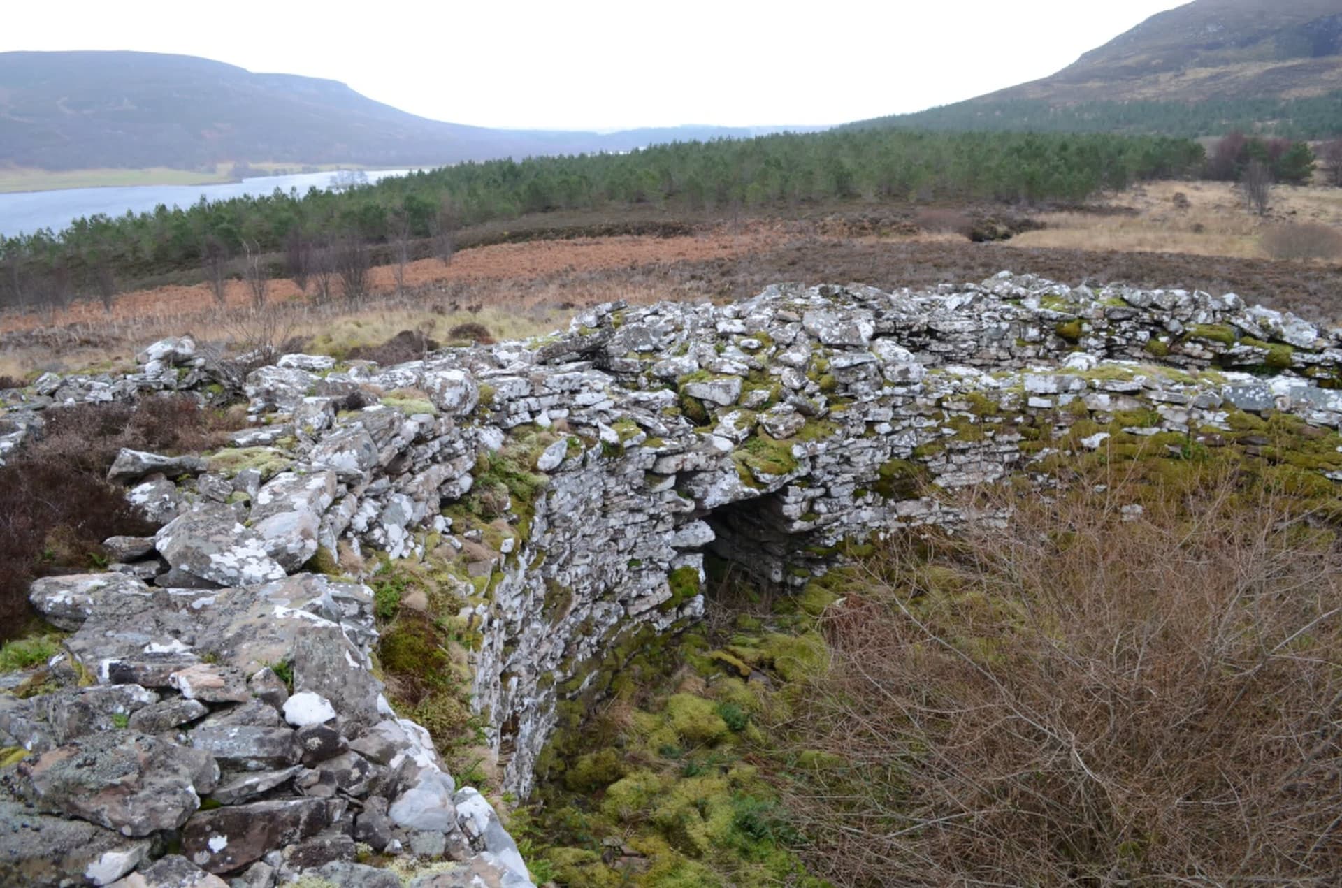
The final approach is across rough ground, heather and grass, climbing the hillock to reach the broch. When you arrive, the walls are immediately impressive: regular courses of flat sandstone slabs rising around you, the interior space open to the sky, the entrance passage dark and intact on the southeast side.
Walk through the entrance passage if you are willing to stoop. The lintel stones overhead have held their position for two millennia. Inside, the passage opens into the broch's circular interior. The scarcement ledge, a projecting course of stone that once supported an upper floor, is clearly visible. A mural chamber, accessed from the passage, opens into the wall thickness. The remains of a stair gallery indicate the tower's original height.
From the rampart formed by the banked excavation spoil, the views are extraordinary. The Moray Firth lies to the east, its waters reflecting the sky. The coast stretches north toward Brora and south toward Dornoch. On clear days, the mountains of the interior Highlands are visible to the west. Golspie lies below, its rooftops and streets visible from this vantage point, a reminder of the two thousand years that separate the broch from the present settlement.
You are almost certainly alone here. The silence is particular: wind, birds, the distant sound of the sea. This is a place that rewards stillness.
Approach from the A9 via the minor road signed to Backies, approximately one kilometre north of Golspie. Park near the Scottish Water Treatment Works sign. Follow the track east to the ruined croft, then cross open ground to the broch on the hilltop. Allow approximately ninety minutes for the round trip including time at the broch. Combine with Carn Liath Broch, three kilometres south along the A9.
Backies Broch contributes to our understanding of Iron Age settlement in Sutherland while raising questions that its limited excavation cannot answer. The site's value lies as much in its atmospheric setting and relative obscurity as in its archaeological record.
Backies is recognised as a significant hollow-walled broch in the Sutherland concentration. The 1846 excavation, documented by Worsaae's sketches, provides evidence of features now lost to deterioration. The site's re-scheduling in 2016 reflects its continued archaeological importance. Finds including pottery, shale ornaments, a jet armlet fragment, and vitrified stone are consistent with domestic occupation. The broch's relationship to the secondary structures within its outer wall is poorly understood.
No oral traditions survive for this broch. In Highland folklore, brochs were attributed to the Picts or to mythical builders. The Gaelic term dun was commonly applied.
Some researchers have proposed that broch design incorporated cosmological and geometric principles, suggesting mathematical knowledge inherited from the Neolithic stone circle tradition. This remains a minority view and has not been specifically demonstrated at Backies.
The circumstances of the broch's abandonment are unknown. The deterioration since 1846 means features documented by Worsaae are being lost. The relationship between the broch and its outer settlement structures is poorly understood. The true original height of the tower cannot be determined.
Visit Planning
Backies Broch is freely accessible year-round. The walk from the road takes approximately twenty minutes each way over rough ground. There are no facilities at the site. Golspie, one kilometre south, offers basic services.
From the A9, follow the minor road signed to Backies approximately one kilometre north of Golspie. Continue for 2.5 km to the Scottish Water Treatment Works sign. Park on the verge. Walk 80 metres up the road, take the track east to a ruined croft. Cross open ground to the broch on the hilltop. Grid reference: NC 8327 0205. No public transport to the site. Not accessible to wheelchairs.
Golspie offers hotels and guest houses. More options in Brora and Dornoch along the A9.
Backies Broch is a Scheduled Ancient Monument on private land with informal access. Respect for the monument and the working farmland is essential.
The broch is freely accessible year-round. No admission is charged. The site is a Scheduled Ancient Monument, legally protected against damage or disturbance.
The approach crosses working farmland. Close any gates and keep dogs under control. The terrain requires sturdy footwear. Weather can change rapidly at this exposed hilltop location.
The site has no facilities, signage, or interpretation. This is part of its character. Treat it as you would any wild place: leave no trace.
No specific requirements beyond practical outdoor clothing. Sturdy footwear essential for the rough approach. Wind-resistant layers advisable.
Photography is unrestricted. The entrance passage, interior scarcement ledge, and panoramic views are particularly rewarding.
Do not leave offerings at the site.
Do not damage, disturb, or remove any material. Do not climb on walls. Do not light fires. Close gates. Keep dogs under control.
Sacred Cluster
Nearby sacred places create the location cluster described in the growth plan. This block is intentionally crawlable and links into the wider regional graph.