Broch of Gurness
An Iron Age tower and village standing where Orkney meets the sea, layered with fourteen centuries of human life
Evie, Orkney Islands, United Kingdom
At A Glance
- Coordinates
- 59.1240, -3.0817
- Suggested Duration
- 1-2 hours to explore the broch village, walk through the settlement, and view the artefacts in the visitor centre. Longer if combining with coastal walks or photography.
Pilgrim Tips
- Outdoor clothing suited to Orkney weather is essential. The site is exposed to wind from Eynhallow Sound. Waterproof layers and sturdy footwear with good grip are recommended, as the ground is uneven with stone steps and level changes.
- Permitted throughout the site. The broch and village photograph well from the elevated areas around the ditches, and the views across Eynhallow Sound toward Rousay provide a dramatic backdrop.
- The Broch of Gurness is a scheduled ancient monument. Do not remove stones, dig, or use metal detectors. Do not leave offerings on the monument. The ground is uneven with numerous steps and level changes.
Overview
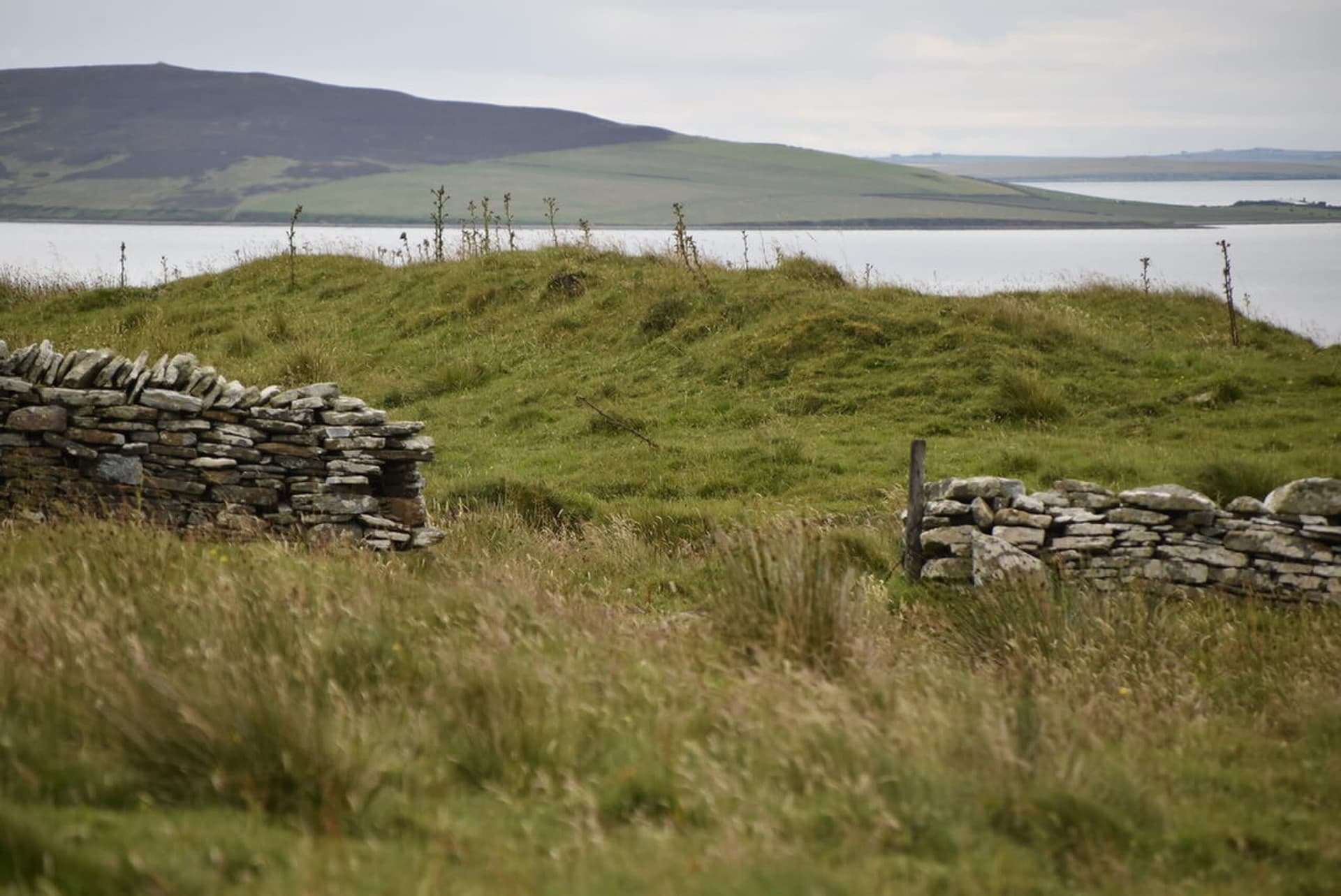
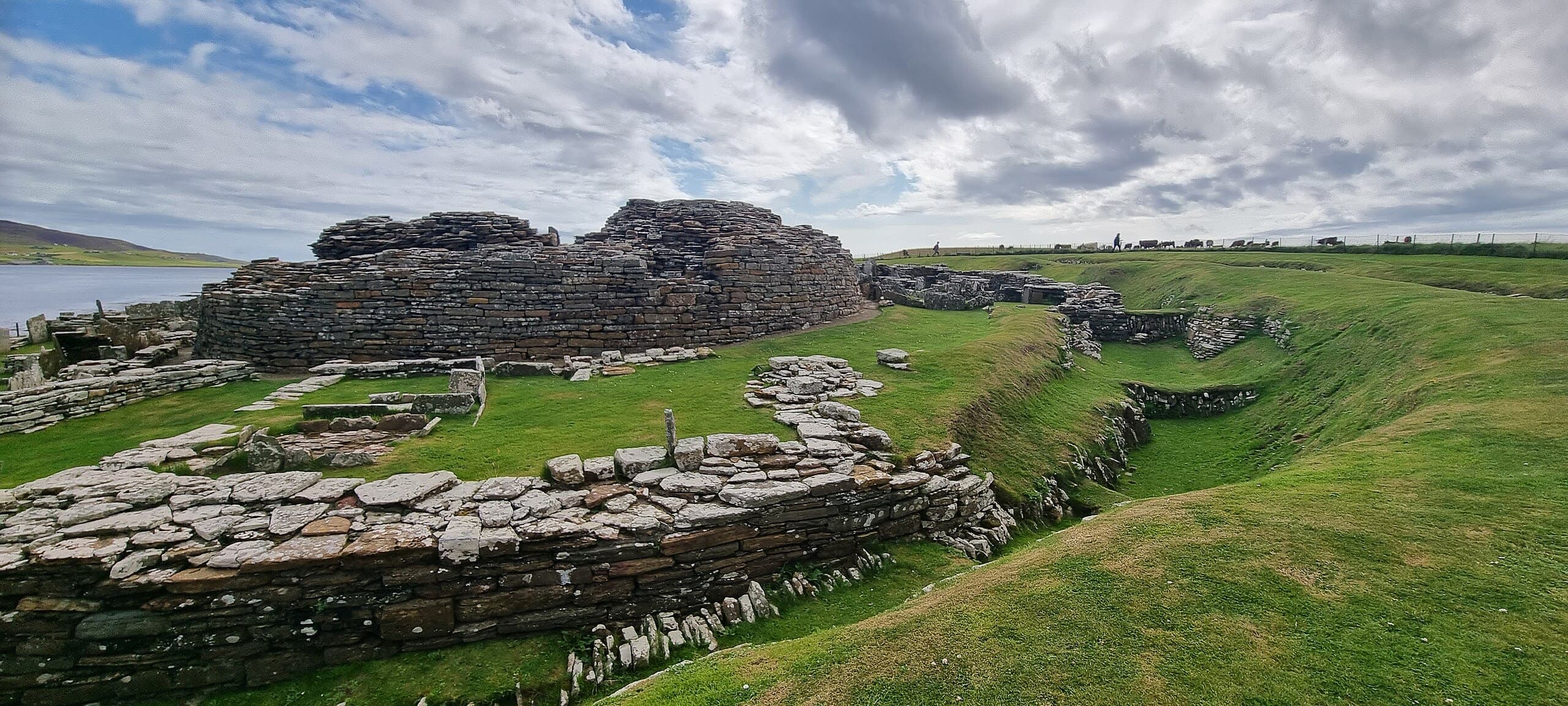
The Broch of Gurness rises from a rocky promontory on Orkney's northwest coast, overlooking the turbulent waters of Eynhallow Sound. Built between 500 and 200 BC, the massive stone tower once stood ten metres tall at the centre of a fortified village where an entire community lived, worked, and sheltered. Three concentric ditches cut from bedrock, a ring of small stone houses, and a subterranean cistern speak to the intensity of life sustained here through the long Orkney winters. Iron Age builders gave way to Pictish settlers who carved their symbols into stone, and then to Norse arrivals who buried their dead in this already ancient mound.
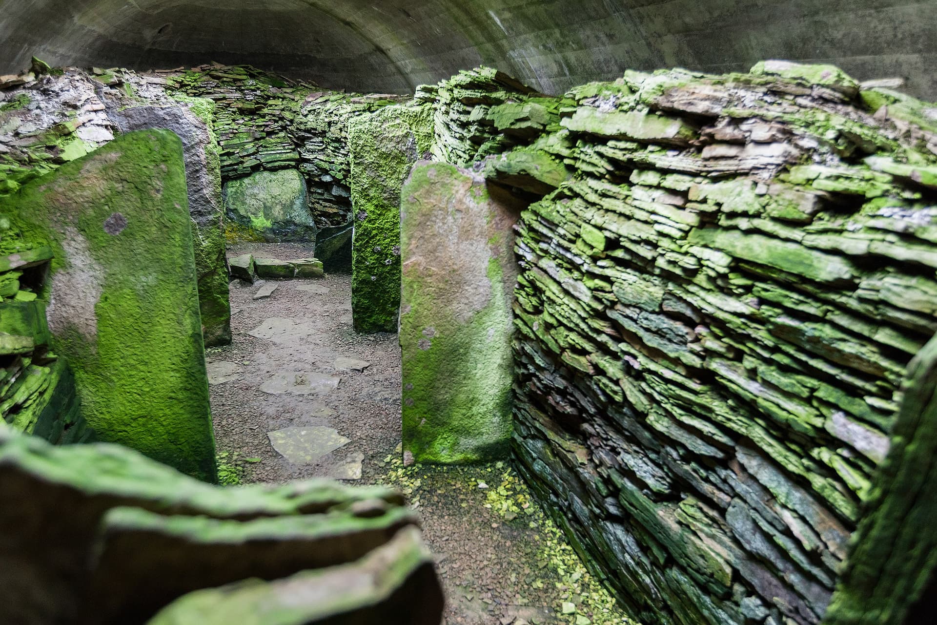
On a low promontory where Orkney's northwest coast meets Eynhallow Sound, the remains of a stone tower and its surrounding village lie open to the sky. The Broch of Gurness was built sometime between 500 and 200 BC, and it was not built modestly. The tower rose to perhaps ten metres, its double-skinned walls more than four metres thick at the base, enclosing an interior space partitioned by upright sandstone flags where hearth fires burned and a stone cistern descended into the earth. Around the tower, a village grew: small stone houses with yards and sheds, arranged within three concentric ditches cut directly from the rock, defended by stone ramparts.
This was not a ceremonial space visited on occasion. It was home. The narrow passages between dwellings, the hearths blackened by use, the rooms scaled for sleeping and cooking and the ordinary business of survival speak to the daily texture of Iron Age life in a place where the wind rarely stops and the sea is never far from hearing.
The community that built Gurness eventually moved on or declined. The broch began to collapse while still inhabited, its interior repartitioned, its cistern filled. Sometime after 100 AD the tower was abandoned, the ditches filled. But the place was not forgotten. In the centuries that followed, Pictish people built smaller dwellings from the broch's repurposed stones, carving their enigmatic symbols and ogham inscriptions into bone and rock. Centuries later still, around AD 850, a Norse woman was buried here in a stone-lined grave with bronze brooches and iron tools, her bones eventually revealing that she had grown up not in Orkney but far to the south, perhaps in Ireland or England.
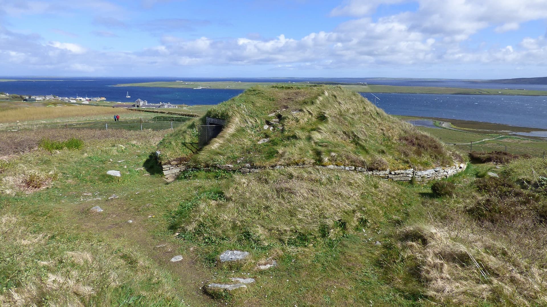
Until 1929, all of this lay hidden beneath a grassy mound known as the Knowe o' Aikerness. The Orcadian poet Robert Rendall was sketching on the mound when one leg of his stool broke through the turf and revealed a staircase descending into darkness. What followed was the uncovering of one of Scotland's most important Iron Age sites, a place where fourteen centuries of human life had been compressed into the earth and preserved by the Orkney grass.
Context And Lineage
The Broch of Gurness is an Iron Age broch village on the northwest coast of Mainland Orkney, built between 500 and 200 BC. It is the best-preserved broch village in Scotland, with a central tower, surrounding settlement, and three defensive ditches. The site was occupied for over fourteen centuries through Iron Age, Pictish, and Norse periods before being lost beneath a grassy mound until its accidental discovery in 1929.
The broch began as a massive circular stone tower built on a rocky promontory overlooking Eynhallow Sound. The community that raised it cut three concentric ditches from the bedrock, built stone ramparts, and added an entrance causeway on the eastern side. A village of small stone houses grew around the tower, enclosed within the defensive rings. The builders left no written account of their reasons for choosing this place, but the promontory commands views across the sound and sits within sight of other brochs lining either shore, suggesting a network of Iron Age communities connected by water.
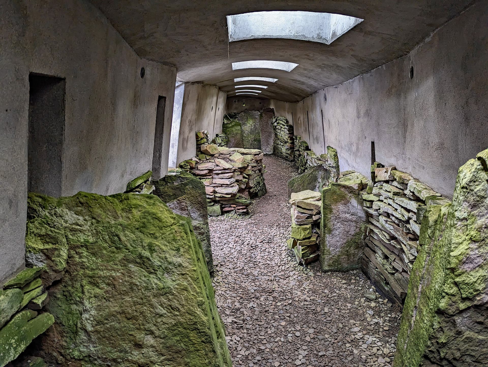
The tower was engineered with double-skinned walls more than four metres thick, stone-floored galleries running between the inner and outer skins, and an interior space of about ten metres diameter. At the centre, a subterranean stone cistern with steps leading down into it served a purpose that remains debated. Two hearths warmed the space. Upright sandstone flags divided the interior into rooms.
The settlement endured through centuries of change. The broch tower began to deteriorate while still inhabited. The cistern was filled, the interior redesigned. Eventually, sometime after 100 AD, the tower was abandoned and its ditches filled. Pictish communities arrived and built anew from the broch's own stones, leaving behind carved symbols and an ogham-inscribed bone knife handle. Around AD 850, a Norse woman was buried in a stone-lined grave on the mound, accompanied by two oval bronze brooches and iron tools. Isotopic analysis of her bones suggests she spent her childhood on the east coast of Ireland or in southeast England, a stranger laid to rest in an ancient place far from her origins.
No continuous cultural or spiritual tradition connects the present day to the Iron Age, Pictish, or Norse communities who occupied the site. The significance of Gurness is understood through archaeological investigation. The site has been managed by the state since 1932, when ownership was transferred into state care during ongoing excavations. Historic Environment Scotland now maintains the monument and visitor centre.
Robert Rendall
Discoverer
James Smith Richardson
First Inspector of Ancient Monuments for Scotland
The Norse Woman
9th-century burial
Why This Place Is Sacred
The Broch of Gurness draws its power not from any single religious tradition but from the sheer density of human life it contains. Fourteen centuries of habitation, from Iron Age builders through Pictish settlers to a Norse burial, have layered this promontory with accumulated meaning. The subterranean cistern, the defensive ditches cut from living rock, and the narrow domestic spaces create an atmosphere of concentrated human intention.
There are places that become sacred through designation, through the founding of temples or the declaration of holy ground. The Broch of Gurness became significant through something more elemental: the sustained commitment of human communities to a single piece of ground across more than a thousand years.
The Iron Age people who built the broch chose this promontory for reasons that can be partially reconstructed. The views across Eynhallow Sound are commanding. The rock beneath could be cut into deep ditches for defence. The sound itself connected communities on either shore, and at least ten brochs once lined its waters. But practical considerations alone do not explain the persistence of settlement here. When the broch tower began to collapse, the community did not leave. They adapted, repartitioned, continued. When the broch was finally abandoned, Pictish people arrived and built again, using the same stones, inhabiting the same ground. When the Norse came to Orkney, they chose this mound for their dead.
The subterranean cistern within the broch carries particular weight. Once dismissed as a simple water source, similar underground chambers across Orkney have been reinterpreted in light of discoveries at sites like Minehowe, where an underground structure at the heart of a metalworking complex was acknowledged as ritual in nature. Whether the Gurness cistern served practical, ceremonial, or both purposes remains an open question, but the steps leading down into darkness, the deliberate construction beneath the tower's centre, suggest something more than utilitarian engineering.
What accumulates at Gurness is not the residue of prayer or pilgrimage but of ordinary life lived with extraordinary intensity. The hearths, the sleeping chambers, the yards where tools were sharpened and food was stored, these are the traces of people who committed their entire existence to this place. That commitment endured across cultural shifts so profound that the language, the religion, and the very people changed while the place remained.
Constructed between approximately 500 and 200 BC as a fortified settlement centred on a massive stone broch tower. The site served as the communal home of a substantial Iron Age community, combining domestic, defensive, and possibly ritual functions within a complex of tower, village, ditches, and ramparts.
The broch was inhabited through its initial construction phase, then continued to be occupied as the tower began to collapse. The interior was repartitioned and the cistern filled. After approximately 100 AD the broch was abandoned and ditches filled, but Pictish settlement continued into the 5th century and beyond, with new structures built from repurposed broch stones. A Norse burial was made at the site around AD 850-950. The site was hidden beneath a grassy mound until Robert Rendall's accidental discovery in 1929. Excavations by the Society of Antiquaries of Scotland ran from 1930 to 1939. Now managed as a scheduled ancient monument by Historic Environment Scotland.
Traditions And Practice
No active ritual practices take place at the Broch of Gurness. The site invites slow, attentive walking through the remains of the village and broch, contemplation of the layered history visible in the stones, and engagement with the artefacts displayed in the visitor centre.
The Iron Age community at Gurness practiced the daily rituals of communal life within a fortified settlement: tending hearths, drawing water from the cistern, farming the surrounding land, and maintaining the defensive works. The subterranean cistern may have served ceremonial as well as practical purposes, though this remains speculative. The Pictish inhabitants carved symbolic designs into stone and bone, practices associated with cultural identity and possibly ritual meaning. The Norse burial followed pre-Christian funerary customs, with the dead woman equipped with personal items for the afterlife.
Visitors walk through the broch village, exploring the domestic spaces and defensive features. The visitor centre displays artefacts recovered from the excavations. The site functions as an archaeological heritage attraction within Orkney's broader landscape of ancient monuments.
Walk slowly through the settlement. Stand inside the broch and attend to the thickness of the walls around you. Notice the domestic scale of the houses, the narrowness of the passages, the marks of hearth fire. Descend to the cistern and consider what it meant to step down into darkness beneath a stone tower. Look out across Eynhallow Sound and imagine the other brochs that once lined its shores. Sit with the thought that a Norse woman from Ireland or England was buried here, far from home, in a mound already ancient when she arrived.
Iron Age Broch Community Life
HistoricalThe Broch of Gurness was the centre of a substantial Iron Age community from approximately 500 BC onward. The massive tower, surrounded by a village of stone houses within three concentric defensive ditches, represents an extraordinary commitment to communal life in a challenging environment. The community farmed, fished, and maintained their settlement through the long Orkney winters, their daily life leaving traces in hearth ash, tool marks, and the worn thresholds of their doorways.
Communal habitation within a fortified settlement. Maintenance of hearths and domestic spaces. Use of the subterranean cistern. Farming and coastal subsistence. Construction and repair of the broch tower, village, and defensive works.
Pictish Settlement and Symbolic Culture
HistoricalAfter the broch was abandoned as a tower, Pictish communities settled at Gurness from approximately the 5th century AD, building new dwellings from the broch's repurposed stones. The distinctive shamrock-shaped house with its central hearth and four radiating chambers represents a different architectural tradition imposed upon the older foundations. A stone carved with Pictish symbols and an ogham-inscribed bone knife handle indicate ongoing cultural and symbolic expression at the site.
Construction of the shamrock house and other dwellings from repurposed broch stones. Pictish symbol carving. Ogham inscription on bone.
Norse Funerary Practice
HistoricalAround AD 850-950, a Norse woman was buried at Gurness in a stone-lined grave with two oval bronze (tortoise) brooches and iron tools including a sickle and knife. She was buried before the Norse adopted Christianity. Isotopic analysis of her bones revealed she grew up not in Orkney but likely on the east coast of Ireland or in southeast England. The Vikings who settled Orkney from about AD 800 frequently used the mounds of earlier settlements as burial sites.
Stone-lined grave burial. Provision of grave goods including jewellery and tools. Selection of an ancient mound as a burial site.
Experience And Perspectives
Approach along the coastal path from the car park. The site reveals itself gradually, the defensive ditches appearing first, then the circular wall foundations of the village, and finally the broch tower at the centre. Walk through the narrow passages between dwellings, descend to the cistern, and stand within the broch's interior where the scale of the walls becomes visceral. Beyond the stones, Eynhallow Sound stretches toward Rousay.
The first impression is of containment. Before you reach the broch itself, you must cross the outermost of three concentric ditches cut from the bedrock, each one deeper, each rampart higher. These ditches encircle an area roughly forty-five metres across, and crossing them shifts the sense of space. The world outside, the farmland, the road, the distant hills, recedes. The world inside the ditches is the world of the settlement.
Within the inner ditch, the village opens around you. Low stone walls trace the outlines of houses, each with a doorway leading to a main room and smaller side chambers. The passages between dwellings are narrow, sometimes barely wide enough for two people to pass. Walk through them slowly. These were not corridors but living spaces, paths worn by daily use over centuries. The scale is intimate and human.
At the centre stands the broch, its walls reduced to perhaps three and a half metres but still massive enough to convey the original intent. The wall thickness is staggering: more than four metres of solid drystone construction with internal galleries between the two skins of stone. Step inside and the interior closes around you, roughly ten metres across, partitioned by sandstone slabs that once divided the single great chamber into smaller rooms. The hearths are visible. The cistern descends.
Look up from inside the broch and imagine ten metres of stone tower above you, tapering toward the Orkney sky. Then look outward through the entrance passage toward Eynhallow Sound, where the water moves between Mainland and Rousay as it has since before the first stone was laid here.
The Pictish shamrock house, reconstructed near the entrance, offers a different architectural sensibility: a central hearth with four radiating chambers, built from the broch's own stones centuries after the tower fell. Near the entrance, the site of the Norse woman's grave is marked, a final layer of human presence added to a place already layered beyond counting.
The visitor centre houses Iron Age artefacts recovered from the excavations. These objects, the tools, the pottery, the fragments of daily life, complete what the stones begin. They remind you that this was not a monument but a home.
The Broch of Gurness is located on the northwest coast of Mainland Orkney, approximately 15 miles northwest of Kirkwall, near the hamlet of Aikerness in the parish of Evie. The site overlooks Eynhallow Sound with views across to the island of Rousay. The entrance faces east, toward the agricultural land that would have sustained the community.
The Broch of Gurness can be understood as an archaeological site of exceptional preservation, as a window into Iron Age social organisation, as evidence of the persistence of place across cultures, or as an invitation to contemplate the depth of human commitment to a single piece of ground.
Archaeologists recognise the Broch of Gurness as the best-preserved broch village in Scotland. The site provides critical evidence for understanding Iron Age social organisation in Orkney, including the relationship between the central broch tower and its surrounding village, the defensive function of the concentric ditches, and the daily life of an Iron Age community. The multiple phases of occupation, from initial broch construction through Pictish reuse to Norse burial, demonstrate the persistent significance of place across major cultural transitions. Recent reinterpretation of subterranean chambers in Orkney brochs, in light of the undisputedly ritual chamber at Minehowe, has raised questions about whether the Gurness cistern served ceremonial as well as practical purposes.
No continuous oral or spiritual tradition survives from any period of the site's active use. The Iron Age, Pictish, and Norse communities who inhabited Gurness left no written records of their relationship to this place. Their stories must be read from the stones, the grave goods, and the carved symbols they left behind.
Some visitors and writers have noted the alignment of brochs along Eynhallow Sound as potentially significant beyond defensive strategy, suggesting that the siting of these structures may relate to ideas about landscape, water, and connection between communities that extended beyond the purely practical. The underground cistern has attracted attention from those interested in the ritual significance of water in ancient cultures.
Much about the Broch of Gurness remains uncertain. The precise function of the subterranean cistern is debated. The identity and story of the Norse woman, and why she was buried so far from her homeland, are unknown. The nature and extent of the Pictish occupation, and the meaning of the symbol stone and ogham inscription found here, are incompletely understood. Whether the three concentric ditches served purely defensive purposes or also carried symbolic significance remains an open question. The relationships between the brochs that once lined Eynhallow Sound, and the nature of the community networks they represent, are still being explored.
Visit Planning
Open April to September, managed by Historic Environment Scotland. Located 15 miles northwest of Kirkwall on Mainland Orkney. Admission fee applies. Allow 1-2 hours. No toilets or cafe on site.
Limited accommodation in the Evie area. The main accommodation options are in Kirkwall (15 miles) or Stromness (20 miles). Several B&Bs and self-catering properties are available in rural west Mainland Orkney. Camping is available at various locations across Orkney.
Treat the broch with respect as a scheduled ancient monument and former dwelling place. Walk carefully on uneven ground. Follow Historic Environment Scotland guidelines. Leave no trace.
The Broch of Gurness was a home for over a thousand years and a burial place for at least one named period. The Norse woman interred here was given grave goods for a journey, and the Iron Age families who lived within these walls committed their daily lives to this ground. The site deserves the respect due to any place where people lived, died, and were remembered. Walk carefully through the narrow passages. Do not sit on or lean against the remaining walls. The stones are ancient and the structures are fragile despite their apparent solidity.
Outdoor clothing suited to Orkney weather is essential. The site is exposed to wind from Eynhallow Sound. Waterproof layers and sturdy footwear with good grip are recommended, as the ground is uneven with stone steps and level changes.
Permitted throughout the site. The broch and village photograph well from the elevated areas around the ditches, and the views across Eynhallow Sound toward Rousay provide a dramatic backdrop.
Do not leave offerings, coins, or objects at the monument. It is a scheduled ancient monument and any interference is a legal offence.
The site is a scheduled ancient monument under Scottish law. Any disturbance, excavation, or use of metal detectors is prohibited without authorisation from Historic Environment Scotland. Dogs are permitted but must be kept on leads and are not allowed in roofed areas.
Sacred Cluster
Nearby sacred places create the location cluster described in the growth plan. This block is intentionally crawlable and links into the wider regional graph.