Wanuskewin
A 6,000-year gathering place where Northern Plains peoples still seek peace of mind
Saskatoon, Saskatchewan, Canada
At A Glance
- Coordinates
- 52.2243, -106.5961
- Suggested Duration
- A minimum of two to three hours covers the visitor centre exhibits and a trail walk. A half-day visit of four to five hours is recommended to include a guided tour, full trail exploration, and the visitor centre. An overnight tipi sleepover provides the most immersive experience.
Pilgrim Tips
- No specific dress code, but dress for the outdoors. The valley trails require comfortable, weather-appropriate clothing and sturdy footwear. Saskatchewan weather can change quickly. Respectful, modest attire is appropriate given the site's sacred significance.
- General photography of the landscape, trails, and visitor centre is permitted. Do not photograph active ceremonies, sacred features being used for prayer, or individuals without permission. No drones are permitted on site. Specific restrictions may apply during ceremonies or special events.
- Closed Indigenous ceremonies — sweat lodges, blessings, specific spiritual gatherings — are by invitation and at the discretion of ceremony leaders. Do not approach or photograph active ceremonies. Certain areas may be restricted during ceremonial use; respect any closures. The medicine wheel is a living sacred feature, not an archaeological exhibit. Approach it with the reverence you would bring to any active place of worship.
Overview
In the sheltered valley of Opimihaw Creek, Northern Plains peoples have gathered for over six millennia to hunt, pray, heal, and find peace. Wanuskewin — a Plains Cree word meaning 'seeking peace of mind' — holds 19 pre-contact archaeological sites within a single compact landscape: bison jumps, tipi rings, a medicine wheel, and petroglyphs uncovered by the very bison whose return fulfilled a living prophecy. The ceremonies continue. The land keeps speaking.
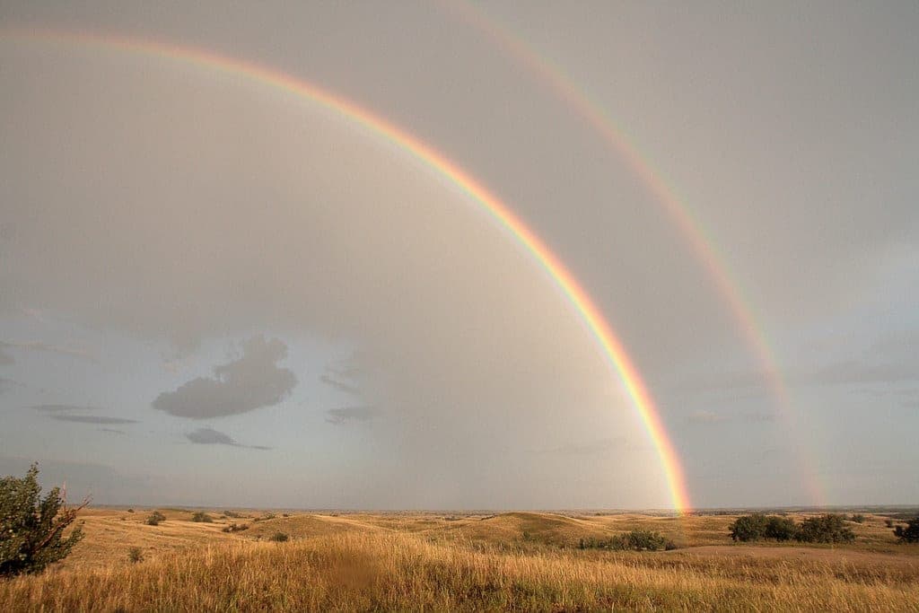
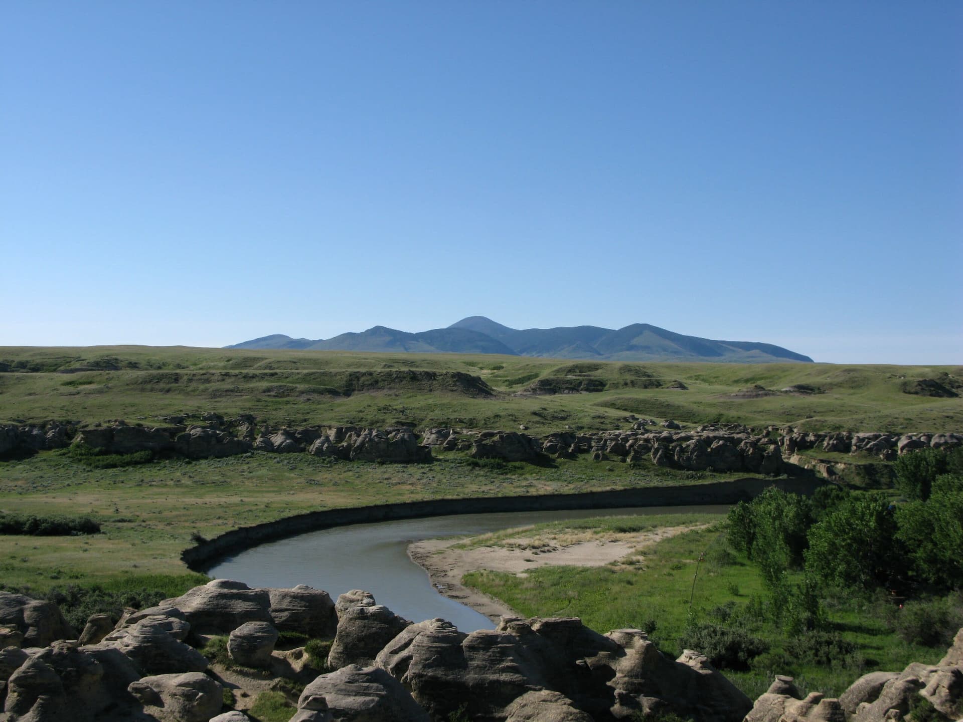
Five kilometres north of Saskatoon, the flat Saskatchewan prairie opens into a deep valley carved by Opimihaw Creek. The shift is sudden. Where moments before the landscape stretched featureless to the horizon, the earth drops away into sheltered terraces, willows along the water, coulees folding inward. For at least 6,000 years, this valley has drawn Indigenous peoples from across the Northern Plains — Cree, Assiniboine, Saulteaux, Dakota, Blackfoot, Atsina — who recognized in its shelter, its water, and its particular quality of enclosure something that the open prairie could not provide. They named it wânaskêwin: the place where one goes to seek peace of mind.
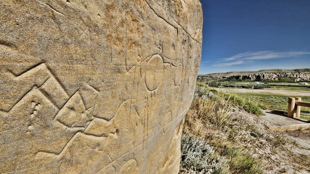
The archaeological record here is extraordinarily concentrated. Nineteen pre-contact sites lie within approximately 240 hectares: bison jumps where hunters drove herds over cliffs in ceremonies that wove spiritual practice into the act of survival, tipi rings marking seasonal camps, processing sites, habitation terraces, and — at the valley's highest point — a medicine wheel dating to 1,500 years ago, the northernmost recorded in North America. In 2021, bison reintroduced to the park after 150 years of absence uncovered four petroglyphs and the carving tool used to create them, buried for approximately a thousand years.
Wanuskewin is not a ruin. Approximately 50 sweat ceremonies are held here each year. Blessings, smudge ceremonies, and gatherings of the Federation of Sovereign Indigenous Nations take place on the same land where ancestors camped six millennia ago. The annual pow-wow at the end of June opens the northern plains pow-wow season. On Canada's tentative list for UNESCO World Heritage designation since 2017, Wanuskewin would become Saskatchewan's first World Heritage Site if inscribed — recognition of what the land and its peoples have known for thousands of years.
Context And Lineage
Archaeological evidence places the first human habitation of Opimihaw Valley at approximately 6,000 to 6,400 years ago. Nineteen pre-contact sites document continuous use across millennia — bison jumps, habitation terraces, tipi rings, a 1,500-year-old medicine wheel, and petroglyphs uncovered in 2021. Designated a National Historic Site in 1987, the park opened to the public in 1992 and joined Canada's UNESCO tentative list in 2017.
The specific origin stories of Wanuskewin's sacredness belong to the oral traditions of the Northern Plains First Nations. What the archaeological record confirms is that the unusual topography of Opimihaw Valley — a deep, wide cut through otherwise flat prairie, offering sheltered terraces alongside fresh water and abundant resources — drew Indigenous peoples from great distances for over six millennia.
The valley was not built. It was recognized. In a landscape defined by exposure, wind, and horizontal endlessness, this fold in the earth offered something rare: shelter, water, game funneled into a contained space, and a quality of enclosure that invited gathering. The name given to it in Plains Cree encodes this recognition — wânaskêwin, seeking peace of mind. The valley was not merely useful; it was understood as a place of sanctuary.
Over thousands of years, that recognition was inscribed into the land itself. Bison jumps were established where the terrain allowed herds to be driven over low cliffs. Tipi rings accumulated on the terraces. A medicine wheel was constructed at the valley's highest point approximately 1,500 years ago. Petroglyphs were carved into boulders. The landscape became a record of its own significance — a palimpsest of human intention written across six millennia.
Wanuskewin represents the longest continuously documented gathering tradition on the Northern Plains. The archaeological record spans at least 6,000 years and encompasses all major Northern Plains cultural groups. The site's transition from private ranch to Provincial Heritage Property (1983), National Historic Site (1987), and public heritage park (1992) involved collaboration between Indigenous communities, the Meewasin Valley Authority, and the City of Saskatoon. First Nations leadership guides the park's cultural programming and ceremonial life. The UNESCO tentative list nomination (2017) positions Wanuskewin within the global framework of outstanding universal heritage.
Northern Plains First Nations (collective)
Original keepers and continuous users
Dr. Ernie Walker
Chief archaeologist and park co-founder
Michael Vitkowski
Former landowner
Darlene Brander
CEO of Wanuskewin Heritage Park (from 2019)
Why This Place Is Sacred
Wanuskewin thins the boundary between past and present through sheer continuity. The same valley that sheltered gatherings 6,000 years ago hosts sweat ceremonies today. The bison whose ancestors were driven over the jump have returned, and in returning, uncovered carvings that had waited a millennium to be found again. The Cree name itself describes the thinning: this is where one comes to seek peace of mind — a function that has not changed.
Descend into the valley from the flat prairie above. The transition is the first thing. Wanuskewin's thinness begins with topography — the abrupt shift from exposed grassland to sheltered creek valley, from wind to stillness, from the horizontal endlessness of the plains to a contained space with walls of earth and trees along water. This is how thousands of years of visitors experienced arrival: leaving one world, entering another.
The sheltered terraces along Opimihaw Creek created conditions for both physical and spiritual sustenance. Here, the bison could be driven and the meat processed. Here, the tipi rings mark where families gathered through the seasons. Here, the medicine wheel was built at the highest point — oriented to the sky from within the valley's embrace. The landscape itself holds a quality of sanctuary that the Cree name describes precisely: wânaskêwin, seeking peace of mind.
What distinguishes Wanuskewin from other ancient sites is the unbroken thread of use. This is not a place where ceremonies once happened. Approximately 50 sweat ceremonies take place here each year. The Federation of Sovereign Indigenous Nations gathers here. The pow-wow that opens each northern plains season happens here. The land has not been abandoned and rediscovered; it has been continuously held as sacred by the peoples whose ancestors first recognized its qualities.
The 2019 return of bison deepened this continuity in ways no one could have predicted. Plains bison had been absent from the valley for over 150 years. Within two years of their reintroduction, their wallowing — rolling in the grass to create dust pits — disturbed the ground and exposed four carved boulders and the stone tool used to create them, buried for approximately a thousand years. Among them was a Ribstone petroglyph associated with bison hunting traditions. The animals whose relationship with Indigenous peoples sustained life on the plains for millennia had, in their return, uncovered art created in their honour. Some have connected this to Indigenous prophecy about the land continuing to share its stories. Whether one reads this as prophecy fulfilled or extraordinary coincidence, the event carries a weight that resists easy explanation.
The thinness at Wanuskewin is not ethereal. It is grounded in earth, in the creek that still flows, in the bison that graze where their ancestors grazed, in the ceremonies that continue without interruption. Six thousand years of human intention have been layered into this valley. The land holds it.
Wanuskewin served as a multi-purpose gathering place for Northern Plains Indigenous peoples: a site of ceremony (medicine wheel, sweat lodges, blessings), communal hunting (bison jumps and pounds), seasonal habitation (tipi rings and camps), and — as the name declares — a place of spiritual renewal and peace-seeking. The valley's shelter, water, and resources made it a natural convergence point drawing peoples from great distances.
The core function has remained remarkably consistent over six millennia. While the specific practices have evolved with the cultures that used the site, the role of Wanuskewin as a gathering place for ceremony, community, and renewal has not changed. The modern era added new layers: designation as a Provincial Heritage Property (1983), declaration as a National Historic Site (1987), opening of a public visitor centre (1992), and a $40-million revitalization beginning in 2019 that included bison reintroduction and a tripling of the visitor centre's size. The park now operates simultaneously as a living sacred site, an archaeological research station, a cultural education centre, and a vehicle for reconciliation between Indigenous and non-Indigenous peoples.
Traditions And Practice
Approximately 50 sweat ceremonies take place at Wanuskewin each year, alongside blessings, smudge ceremonies, and gatherings of the Federation of Sovereign Indigenous Nations. The annual pow-wow in late June opens the northern plains season. The medicine wheel remains an active site for offerings and prayer. General visitors engage through guided tours, interpretive programs, trail walks, and cultural demonstrations.
The archaeological record documents practices spanning millennia. Bison jumps and pounds, operational from approximately 2,000 to 500 years before present, were not merely economic activities but were accompanied by ceremony and spiritual protocols — the relationship between hunter and hunted was understood as sacred. Tipi rings mark seasonal gatherings where communal and ceremonial life intertwined. The medicine wheel, constructed approximately 1,500 years ago at the valley's highest point, served as a centre for offerings, songs, and prayer. The Ribstone petroglyphs, carved approximately 1,000 years ago and uncovered in 2021, belong to the Hoofprint Tradition of rock art associated with bison hunting ceremony.
Wanuskewin remains a site of active Indigenous ceremony. Approximately 50 sweat ceremonies are held each year, along with numerous blessings and smudge ceremonies. The Federation of Sovereign Indigenous Nations holds meetings and ceremonies at the park. Local Indigenous peoples use the medicine wheel for offerings, ceremonies, and songs. The annual pow-wow at the end of June kicks off the northern plains pow-wow season and is a major cultural event open to the public. Weekend dance and music presentations feature dancers, drummers, or fiddlers every Saturday and Sunday afternoon. The bison restoration program, begun in 2019, reconnects the ecological and spiritual relationship between land, animals, and people that defined Northern Plains life for thousands of years.
Walk the valley trails slowly. Allow the descent from the flat prairie above to register physically — the shift in wind, temperature, and sound that made this valley a natural sanctuary. Spend time at each archaeological site, reading the interpretive markers and imagining the terraces occupied, the fires lit, the herds moving through. Observe the bison from a respectful distance; their presence on this land after 150 years of absence carries meaning that extends beyond conservation biology.
If the medicine wheel is accessible, approach it quietly. Do not touch or disturb any offerings or sacred objects. Stand at the valley's highest point and look out across the landscape that Indigenous peoples have looked across for six millennia.
Participate in a guided interpretive tour for deeper context. The five core year-round programs — covering bison, medicinal plants, traditional games, and Indigenous dance — provide structured entry points. Taste traditional cuisine if offered. If visiting in late June, attend the pow-wow: the drumming, regalia, and community gathering enact the very tradition that makes this valley what it is.
Plains Cree (nēhiyawak)
ActiveThe name Wanuskewin (wânaskêwin) is a nēhiyawēwin (Plains Cree) word meaning 'seeking peace of mind' or 'sanctuary.' The Cree have gathered at this site for millennia, using Opimihaw Valley for ceremony, healing, and community gathering. The site's very name, which has become its public identity, reflects its core spiritual function as understood in Cree tradition.
Sweat ceremonies, blessings, smudge ceremonies, pow-wows, community gatherings, and prayer at the medicine wheel. Approximately 50 sweat ceremonies are held annually. The annual pow-wow in late June, opening the northern plains season, is a major gathering.
Assiniboine (Nakoda)
ActiveThe Assiniboine are among the principal Northern Plains peoples who have used Wanuskewin as a gathering place. Archaeological evidence of their presence is woven into the 19 excavation sites, including bison jumps and habitation terraces that document seasonal use over thousands of years.
Ceremonial gatherings, seasonal camps, and bison hunting practices evidenced by the bison jumps and pounds at the site. Contemporary ceremonial participation continues.
Saulteaux (Anishinaabe)
ActiveOne of the Northern Plains peoples who gathered at Wanuskewin over millennia. Their presence is documented in the archaeological record and in contemporary ceremonial use of the site.
Ceremonial gatherings and spiritual practices at the heritage park. Participation in the broader community of First Nations that sustain Wanuskewin's ceremonial life.
Dakota
ActiveAmong the Northern Plains peoples for whom Wanuskewin served as a gathering place. Archaeological evidence spans multiple millennia, documenting the Dakota relationship with this landscape.
Ceremonial and community gatherings. Participation in the continuing use of Wanuskewin as a gathering and ceremonial site.
Blackfoot (Niitsitapi)
ActiveThe Blackfoot are documented among the Northern Plains peoples who utilized Wanuskewin. Their presence contributes to the site's representation of all major Northern Plains cultural groups within a single compact landscape.
Ceremonial and community gatherings at the site, documented through archaeology and continuing in the present.
Archaeological and conservation stewardship
ActiveSince 1982, Wanuskewin has hosted Canada's longest continuously running archaeological research program. The University of Saskatchewan has produced nearly 200,000 artefacts from the 19 sub-sites. The bison restoration program, launched in 2019, represents active ecological and cultural conservation. The $40-million revitalization expanded the visitor centre and refurbished trails.
Ongoing archaeological excavation and research. Bison conservation herd management. Restoration of agricultural land to native grasses. Heritage interpretation and guided programming. Pursuit of UNESCO World Heritage inscription.
Experience And Perspectives
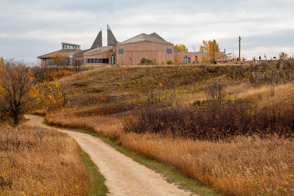
The prairie drops away and you descend into a valley that six millennia of gathering have shaped. Trails wind through terraces along Opimihaw Creek, past bison jump sites and tipi rings. At the highest point, the medicine wheel holds its quiet. Bison graze in peripheral vision. The interpretive centre contextualizes what the land already communicates: that this place has been held as sanctuary for longer than most civilizations have existed.
Drive north from Saskatoon for five minutes. The city gives way to prairie — flat, open, wind-scoured. Follow the buffalo signs. When you reach Wanuskewin, the parking lot sits on the plain above the valley. From here, the land looks unremarkable. Walk toward the edge.
The valley opens below you. Opimihaw Creek has carved a wide, deep channel through the prairie, creating sheltered terraces along its course. Willows and native grasses line the water. The contrast with the exposed plains above is immediate and physical — temperature drops, wind falls, sound changes. You understand, in the body, why peoples walked great distances across the open grasslands to reach this place.
The refurbished trails descend into the valley and wind through the archaeological landscape. Interpretive markers identify the sites that archaeologist Dr. Ernie Walker catalogued beginning in 1982: bison jumps where herds were driven over low cliffs, processing areas where meat and hides were prepared, habitation terraces where families camped, tipi rings pressed into the earth by stones that held down hide shelters. The scale is compact — 19 pre-contact sites within walking distance of one another — yet the timescale is vast. You are walking through layers of human presence reaching back more than 6,000 years.
At the valley's highest point sits the medicine wheel, approximately 1,500 years old and the northernmost recorded in North America. Approach it with the reverence the site asks. This is not a relic. Indigenous practitioners still come here for offerings, ceremonies, and songs.
The bison are often visible from the trails — a conservation herd reintroduced in 2019 after more than 150 years of absence. They move through the valley with an unhurried weight. It was these animals, wallowing in the grass, who uncovered the petroglyphs in 2021 — carvings and a carving tool buried for a thousand years, including a Ribstone associated with bison hunting traditions.
Return to the visitor centre, which was more than tripled in size during the 2020 renovations. Interactive exhibits, art galleries, and presentation spaces help contextualize the experience. On Saturday and Sunday afternoons, live dancers, drummers, or fiddlers perform. Five core interpretive programs run year-round, covering bison, medicinal plants, traditional games, and Indigenous dance. Guided tours deepen what the self-guided walk introduces.
For those seeking fuller immersion, the tipi sleepover experience offers a night on the land. Traditional cuisine is available. The annual pow-wow in late June, opening the northern plains season, transforms the valley into a gathering of the kind that has occurred here for millennia — drums, regalia, dance, community coming together in a place that exists for precisely this purpose.
The visitor centre sits at the valley rim. Trails descend into the Opimihaw Creek valley and loop through the archaeological sites. The medicine wheel is at the highest point in the park. Bison graze in designated areas — observe from a respectful distance. Allow the contrast between the flat prairie above and the sheltered valley below to orient you; the shift in atmosphere upon descent is itself part of the experience. Check at the visitor centre for current trail conditions and any ceremony-related closures.
Wanuskewin invites multiple readings that are not in competition. Archaeological science documents 6,000 years of continuous habitation. Indigenous tradition affirms the site as a living place of ceremony and peace-seeking. Both perspectives converge on the same recognition: this valley has held significance for longer than most human institutions have existed, and it continues to hold it.
Archaeologists and historians confirm Wanuskewin as one of the most significant pre-contact archaeological sites on the Northern Plains. The University of Saskatchewan has managed the longest continuously running archaeological research program in Canadian history here since 1982, producing nearly 200,000 artefacts. The 19 sub-sites within approximately 240 hectares provide a remarkably complete and compact record of cultural development: bison jumps and pounds, habitation sites, tipi rings, processing areas, a medicine wheel, and petroglyphs.
The site's designation as a National Historic Site (1987) and placement on Canada's UNESCO tentative list (2017) reflect scholarly consensus on its exceptional archaeological and cultural value. The UNESCO nomination is based on the concentration of archaeological evidence — the sheer density of sites within a compact area, representing a complete record of Northern Plains cultural development spanning six millennia. If inscribed, it would become Saskatchewan's first World Heritage Site.
The 2021 petroglyph discovery added a significant new dimension to the record. The find — four carved boulders and the carving tool, including a Ribstone petroglyph of the Hoofprint Tradition — was made possible by the bison reintroduction, an intersection of ecological restoration and archaeological discovery that researchers describe as exceptional. The rarity of finding multiple petroglyphs together with the tool used to create them makes this among the most significant discoveries in the park's history.
For the Northern Plains First Nations — Cree, Assiniboine, Saulteaux, Dakota, Blackfoot, and Atsina — Wanuskewin is a sacred gathering place whose significance extends beyond what archaeology can measure. The Plains Cree name wânaskêwin (seeking peace of mind, or sanctuary) encodes the site's spiritual essence. This is not a historical curiosity but a living place where the relationship between people, land, and spirit has been maintained for millennia.
Contemporary Indigenous nations continue to affirm the site as a place of active ceremony. Sweat lodges, blessings, smudge ceremonies, pow-wows, and gatherings of the Federation of Sovereign Indigenous Nations maintain the connection that ancestors established. The medicine wheel remains a site for offerings, ceremonies, and songs — not a monument to past practice but a feature of ongoing spiritual life.
The return of bison in 2019 and their subsequent uncovering of the petroglyphs has been connected with Indigenous prophecy about the land continuing to share its stories. The park operates under First Nations leadership and guidance, ensuring that traditional knowledge and authority shape all programming and interpretation. From this perspective, the archaeological record confirms what oral tradition already knew: this valley has always been a place of gathering, ceremony, and peace.
Some visitors approach Wanuskewin as a site of concentrated earth energy — a 'power place' where millennia of ceremonial use have created an atmosphere distinct from the surrounding prairie. The unusual topography, the sheltered creek valley cutting through flat grassland, and the palpable quality of peace reported by visitors lend the site qualities consistent with what some traditions call a 'thin place.' The return of bison and their uncovering of ancient art has deepened this perception for some.
However, any esoteric interpretation of Wanuskewin should defer to the Indigenous traditions that have maintained this site's sacredness for over 6,000 years. The park's educational mission emphasizes authentic Indigenous perspectives. Visitors seeking spiritual experiences are encouraged to engage with the site on its own terms — through the interpretive programs, guided tours, and cultural offerings — rather than through frameworks imported from other traditions.
Several aspects of Wanuskewin remain incompletely understood. The specific ritual functions and possible astronomical alignments of the 1,500-year-old medicine wheel have not been fully documented. The oral traditions and origin stories associated with the site across the various First Nations are largely held within communities and are not publicly available. The full extent of undiscovered archaeological material remains unknown — the 2021 petroglyph discovery demonstrated that major finds may still lie beneath the surface. The dating of the petroglyphs ranges from 300 to 1,800 years depending on interpretation method, though contextual analysis places them at approximately 1,000 years old. Whether purely practical factors — shelter, water, game — fully explain why this particular valley drew peoples so consistently for over six millennia, or whether other factors contributed to its selection as a sacred gathering place, remains an open question.
Visit Planning
Open year-round, five minutes north of downtown Saskatoon. Summer offers the fullest experience with the late-June pow-wow as the cultural highlight. Allow at least half a day. Admission is $16 for adults. The park is well-signed from Highway 11.
Saskatoon offers a full range of accommodations, from budget to luxury, all within 15 minutes of Wanuskewin. The tipi sleepover experience at the park itself provides the most immersive overnight option. Check wanuskewin.com for seasonal availability and booking.
Respect Wanuskewin as a living sacred site. Stay on designated trails. Do not disturb archaeological features, sacred objects, or active ceremonies. No pets, bikes, or drones permitted.
Wanuskewin is simultaneously a public heritage park and an active sacred site. The two roles coexist because visitors maintain appropriate respect.
The land itself is the primary artefact. Stay on designated trails. Do not remove, touch, or disturb any archaeological features, artefacts, or natural elements. The tipi rings, bison jump edges, and processing sites are irreplaceable records of six millennia of human presence.
Ceremonies take place throughout the year. If you encounter an active ceremony — a sweat lodge in use, a blessing, a smudge — give it wide berth. Do not approach, photograph, or attempt to participate unless explicitly invited. Respect any temporary closures of trails or areas.
The medicine wheel is a living sacred feature. Indigenous practitioners still make offerings, sing, and pray here. Approach quietly. Do not leave unauthorized offerings or disturb any existing prayer items or sacred objects.
The bison are not tame. Observe from a respectful distance. Do not approach, feed, or attempt to interact with them.
The park operates under First Nations leadership and guidance. This shapes all programming and access. The educational mission is one of reconciliation and peaceful co-existence. Engage with that mission by listening, learning, and carrying what you learn beyond the valley.
No specific dress code, but dress for the outdoors. The valley trails require comfortable, weather-appropriate clothing and sturdy footwear. Saskatchewan weather can change quickly. Respectful, modest attire is appropriate given the site's sacred significance.
General photography of the landscape, trails, and visitor centre is permitted. Do not photograph active ceremonies, sacred features being used for prayer, or individuals without permission. No drones are permitted on site. Specific restrictions may apply during ceremonies or special events.
Offerings at the medicine wheel and other sacred features are made by Indigenous practitioners within their own ceremonial protocols. Do not leave unauthorized offerings or disturb any existing prayer items or sacred objects.
No pets except certified service dogs. No bikes, e-bikes, ATVs, or other motorized vehicles on valley walking trails. No drones permitted on site. Stay on designated trails. Respect closed areas, particularly during active ceremonies. Do not disturb archaeological features, artefacts, or natural elements.
Sacred Cluster
Nearby sacred places create the location cluster described in the growth plan. This block is intentionally crawlable and links into the wider regional graph.