Palestinian Territories
Judea and Samaria
5 sites

Hebron/Al-Khalil Old Town
Hebron (; Arabic: الخليل al-Khalīl, or خَلِيل الرَّحْمَن Khalīl al-Raḥmān; Hebrew: חֶבְרוֹן Ḥevrōn, ) is a Palestinian city in the southern West Bank, 30 kilometres (19 mi) south of Jerusalem. Hebron is capital of the West Bank's largest governorate, known as Hebron Governorate. With a population of 201,063 in the city limits, the adjacent metropolitan area within the governorate is home to over 700,000 people. Hebron spans across an area of 74.1 square kilometres (28.6 sq mi). It is the third largest city in the country, followed by Gaza and Jerusalem. The city is often considered one of the four holy cities in Judaism as well as in Islam and Christianity. It is considered one of the oldest cities in the Levant. According to the Bible, Abraham settled in Hebron and bought the Cave of the Patriarchs as burial place for his wife Sarah. Biblical tradition holds that the patriarchs Abraham, Isaac, and Jacob, along with their wives Sarah, Rebecca, and Leah, were buried in the cave. The city is also recognized in the Bible as the place where David was anointed king of Israel. Following the Babylonian captivity, the Edomites settled in Hebron. During the first century BCE, Herod the Great built the wall that still surrounds the Cave of the Patriarchs, which later became a church, and then a mosque. With the exception of a brief Crusader control, successive Muslim dynasties ruled Hebron from the 6th century CE until the Ottoman Empire's dissolution following World War I, when the city became part of British Mandatory Palestine. The 1929 riots and the Arab uprising of 1936–39 led the British government to evacuate the Jewish community from Hebron. The 1948 Arab–Israeli War saw the entire West Bank, including Hebron, occupied and annexed by Jordan, and since the 1967 Six-Day War, the city has been under Israeli military occupation. Following Israeli occupation, Jewish presence was restored in the city. Since the 1997 Hebron Protocol, most of Hebron has been governed by the Palestinian National Authority. The city is often described as a "microcosm" of the Israeli–Palestinian conflict and the Israeli occupation of the West Bank. The 1997 protocol divided the city into two sectors—H1 Hebron, controlled by the Palestinian National Authority, and H2 Hebron, managed by Israeli authorities. All security arrangements and travel permits for local residents are coordinated between the Palestinian Authority and Israel via the COGAT. The Jewish settlers have their own governing municipal body, the Committee of the Jewish Community of Hebron. The largest city in the southern West Bank, Hebron is chief commercial and industrial center in the region. It is a busy hub of trade, generating roughly a third of the area's GDP, largely due to the sale of limestone from quarries in its area. Hebron has a local reputation for its grapes, figs, ceramics, plastics, pottery workshops, metalworking and glassblowing industry. The city is home to numerous shopping malls. The Old City of Hebron features narrow, winding streets, flat-roofed stone houses, and old bazaars. It is recognized as a World Heritage Site by the UNESCO. Hebron is also known as a regional educational and medical hub.

Mount Gerizim, Nablus
Mount Gerizim, Nablus, Israel is a site of sacred significance. Approximate coordinates: 32.19460, 35.26490. Located in מועצה אזורית שומרון, יהודה ושומרון, Palestinian Territory.

Rachel's Tomb
Rachel's Tomb is a site of sacred significance. Approximate coordinates: 31.71931, 35.20200. Located in بيت لحم, الضفة الغربية, Palestinian Territory.

Samuel (The Prophet)‘s Grave
Samuel (The Prophet)‘s Grave, Jerusalem is a site of sacred significance. Approximate coordinates: 31.83278, 35.18032. Located in יהודה ושומרון, Palestinian Territory.
Tomb of Rachel, Bethlehem
Tomb of Rachel, Bethlehem, Israel is a site of sacred significance. Approximate coordinates: 31.71931, 35.20201. Located in بيت لحم, الضفة الغربية, Palestinian Territory.
West Bank
6 sites

Ancient Jericho/Tell es-Sultan
Jericho ( JERR-ik-oh; Arabic: أريحا, romanized: Arīḥā, IPA: [ʔaˈriːħaː] ) is a city in the West Bank, Palestine; it is the administrative seat of the Jericho Governorate of Palestine. Jericho is located in the Jordan Valley, with the Jordan River to the east and Jerusalem to the west. In 2017, it had a population of 20,907. From the end of the era of Mandatory Palestine, the city was annexed and ruled by Jordan from 1949 to 1967 and, with the rest of the West Bank, has been subject to Israeli occupation since 1967; administrative control was handed over to the Palestinian Authority in 1994. Jericho is among the oldest cities in the world, and it is also the city with the oldest known defensive wall. Archaeologists have unearthed the remains of more than 20 successive settlements in Jericho, the first of which dates back 11,000 years (to 9000 BCE), almost to the very beginning of the Holocene epoch of the Earth's history. Copious springs in and around the city have attracted human habitation for thousands of years. Jericho is described in the Bible as the "city of palm trees". In 2023, the archaeological site in the center of the city, known as Tell es-Sultan / Old Jericho, was inscribed in UNESCO's list as a World Heritage Site in the State of Palestine, and described as the "oldest fortified city in the world".

Bethlehem
Bethlehem is a city in the West Bank of Palestine, located about ten kilometres (six miles) south of Jerusalem. It is the capital of the Bethlehem Governorate, and as of 2017 had a population of 28,591 people. The city's economy is strongly linked to tourism, with a focus on the Christmas period, when Christians embark on a pilgrimage to the Church of the Nativity, which is revered as the location of the birth of Jesus. A possible first mention of Bethlehem is in the Amarna correspondence of ancient Egypt, dated to 1350–1330 BCE, although that reading is uncertain. In the Hebrew Bible, the period of the Israelites is described; it identifies Bethlehem as the birthplace of David. In the New Testament, the city is identified as the birthplace of Jesus of Nazareth. Under the Roman Empire, the city of Bethlehem was destroyed by Hadrian, but later rebuilt by Constantine the Great, who commissioned the Church of the Nativity in 327 CE. In 529, the Church of the Nativity was heavily damaged by Samaritans involved in the Samaritan revolts; following the victory of the Byzantine Empire, it was rebuilt by Justinian I. Later, during the rule of several Caliphates, Bethlehem became part of Jund Filastin in 637. Muslims continued to rule the city until 1099, when it was conquered by the Crusaders, who replaced the local Christian Greek Orthodox clergy with Catholic ones. In the mid-13th century, Bethlehem's walls were demolished by the Mamluk Sultanate. However, they were rebuilt by the Ottoman Empire in the 16th century when it came to control the region. After the dissolution of the Ottoman Empire at the end of World War I, Bethlehem was part of Mandatory Palestine until 1948, and later of the West Bank that was annexed by Jordan following the 1948 Arab–Israeli War. During the 1967 Six Day War, Bethlehem was occupied by Israel along with the rest of the West Bank. Since the Oslo Accords between Israel and the Palestinian National Authority, Bethlehem has been designated as part of Area A of the West Bank, nominally rendering it as being under Palestinian control, but it remains under Israeli occupation. Movement around the city is limited due to the Israeli West Bank barrier. While it was historically a city of Arab Christians, Bethlehem now has a majority of Arab Muslims; while it is still home to a significant population of Palestinian Christians, this community has dwindled significantly, from about 86 per cent in 1950 to about 10 per cent in 2022. Presently, Bethlehem has become encircled by dozens of Israeli settlements, which significantly hinder the ability of Palestinians in the city to openly access their land and livelihoods, which has contributed to the exodus of Palestinians.
Mount Gerizim
Mount Gerizim ( GHERR-iz-im; Samaritan Hebrew: ࠄࠟࠓࠬࠂࠟࠓࠩࠆࠝࠉࠌ, romanized: ʾĀ̊rgā̊rīzem; Hebrew: הַר גְּרִזִים, romanized: Har Gərīzīm; Arabic: جَبَل جَرِزِيم, romanized: Jabal Jarizīm, or جَبَلُ ٱلطُّورِ, Jabal at-Ṭūr) is one of two mountains in the immediate vicinity of the Palestinian city of Nablus and the biblical city of Shechem. It forms the southern side of the valley in which Nablus is situated, the northern side being formed by Mount Ebal. The mountain is one of the highest peaks in the West Bank and rises to 881 m (2,890 ft) above sea level, 70 m (230 ft) lower than Mount Ebal. The mountain is particularly steep on the northern side, is sparsely covered at the top with shrubbery, and lower down there is a spring with a high yield of fresh water. For the Samaritan people, most of whom live around it, Mount Gerizim is considered the holiest place on Earth. The mountain is mentioned in the Bible as the place where, upon first entering the Promised Land after the Exodus, the Israelites performed ceremonies of blessings, as they had been instructed by Moses. Mount Gerizim is sacred to the Samaritans, who regard it, rather than Jerusalem's Temple Mount, as the location chosen by God for a holy temple. In Samaritan tradition, it is the oldest and most central mountain in the world, towering above the Great Flood and providing the first land for Noah’s disembarkation. It is the location where Abraham almost sacrificed his son Isaac. A Samaritan Temple was located on Mount Gerizim from the 5th century BCE to the 2nd century BCE. Jews, on the other hand, consider the location of the near-sacrifice to be Mount Moriah, traditionally identified by them with the Temple Mount. Mount Gerizim continues to be the centre of Samaritan religion, and Samaritans ascend it three times a year: at Passover, Shavuot and Sukkot. Passover is still celebrated by the Samaritans with a lamb sacrifice on Mount Gerizim. The Samaritan village of Kiryat Luza and an Israeli settlement, Har Brakha, are situated on the ridge of Mount Gerizim. During the First Intifada in 1987, many Samaritan families relocated from Nablus to Mount Gerizim to avoid the violence. Today, about half of the remaining Samaritans live in close proximity to Gerizim, mostly in the village of Kiryat Luza.
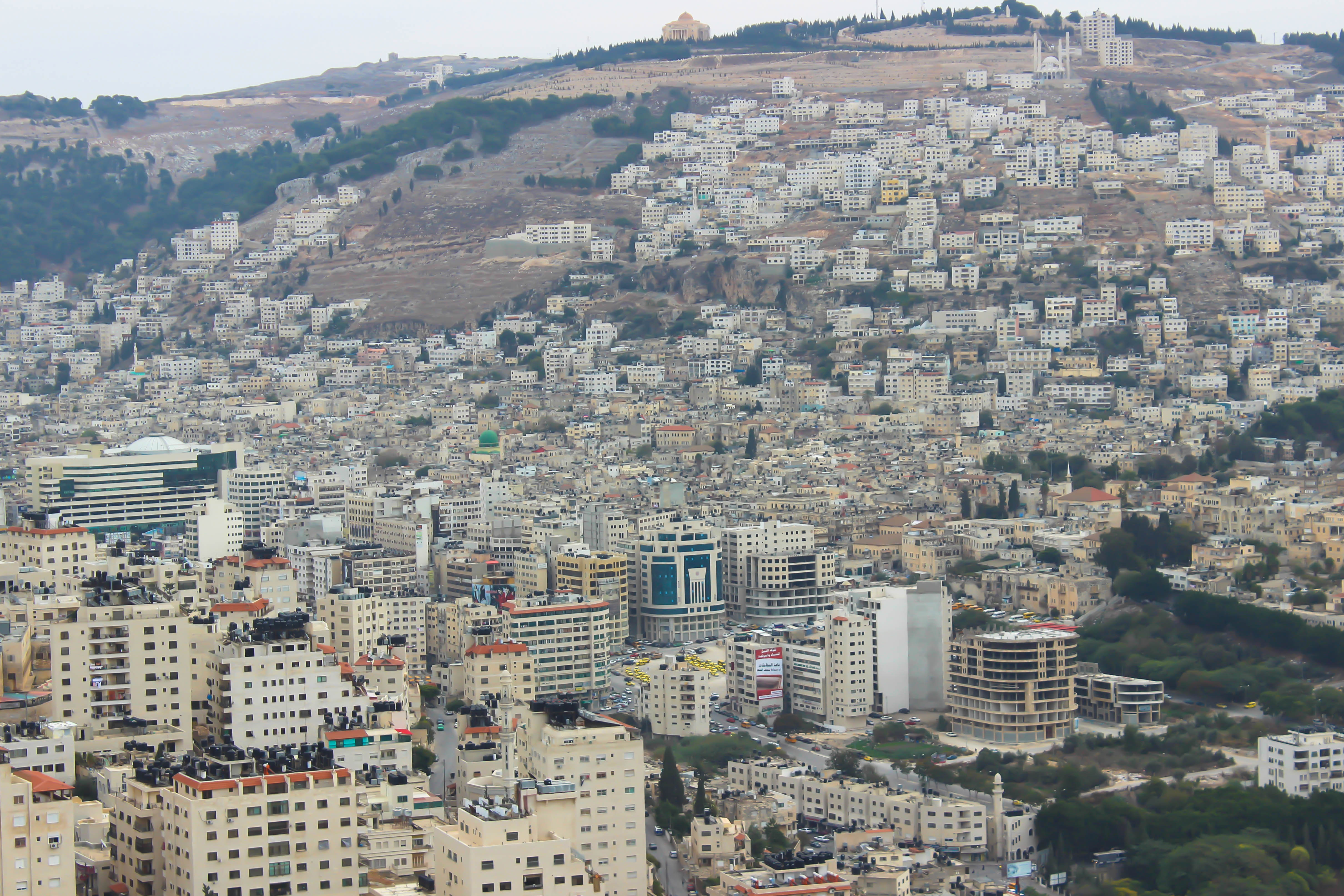
Nablus
Nablus ( NA(H)B-ləs; Arabic: نابلس, romanized: Nābulus, locally [ˈnæːblɪs] ) is a Palestinian city in the West Bank, located approximately 49 kilometres (30 mi) north of Jerusalem, with a population of 156,906. Located between Mount Ebal and Mount Gerizim, it is the capital of the Nablus Governorate and a commercial and cultural centre of the State of Palestine, home to An-Najah National University, one of the largest Palestinian institutions of higher learning, and the Palestine Stock Exchange. Nablus is under the administration of the Palestinian National Authority (PNA). The modern name of the city can be traced back to the Roman period, when it was named Flavia Neapolis by Roman emperor Vespasian in 72 CE. During the Byzantine period, conflict between the city's Samaritan and newer Christian inhabitants peaked in the Samaritan revolts that were eventually suppressed by the Byzantines by 573, which greatly dwindled the Samaritan population of the city. Following the Muslim conquest of the Levant in the 7th century, the city was given its present-day Arabic name of Nablus. After the First Crusade, the Crusaders drafted the laws of the Kingdom of Jerusalem in the Council of Nablus, and its Christian, Samaritan, and Muslim inhabitants prospered. The city then came under the control of the Ayyubids and the Mamluk Sultanate. Under the Ottoman Turks, who conquered the city in 1517, Nablus served as the administrative and commercial centre for the surrounding area corresponding to the modern-day northern West Bank. Much of Nablus' history is preserved in its Old City, which contains more than 100 monumental buildings. After the city was captured by British forces during World War I, Nablus was incorporated into Mandatory Palestine in 1922. The 1948 Arab–Israeli War saw the entire West Bank, including Nablus, occupied and annexed by Transjordan. Since the 1967 Arab–Israeli War, the West Bank has been occupied by Israel; since 1995, it has been governed by the Palestinian Authority as part of Area A of the West Bank. Today, the population is predominantly Muslim, with small Christian and Samaritan minorities.

Shechem
Shechem ( SHEK-əm; Hebrew: שְׁכֶם, romanized: Šəḵem, Biblical pronunciation: [ʃəˈxɛm]; Samaritan Hebrew: ࠔࠬࠥࠊࠝࠌ, romanized: Šăkēm), also spelled Sichem ( SIK-əm; Ancient Greek: Συχέμ, romanized: Sykhém) and other variants, was an ancient city in the southern Levant. Mentioned as a Canaanite city in the Amarna Letters, it later appears in the Hebrew Bible as the first capital of the Kingdom of Israel following the split of the United Monarchy. According to Joshua 21:20–21, it was located in the tribal territorial allotment of the tribe of Ephraim. Shechem declined after the fall of the northern Kingdom of Israel. The city later regained its importance as a prominent Samaritan center during the Hellenistic period. Traditionally associated with the city of Nablus, Shechem is now identified with the nearby site of Tell Balata in the Balata al-Balad suburb of the West Bank.
St. George's Monastery, Al-Khader, West Bank
St. George's Monastery, Al-Khader, West Bank, Palestine is a site of sacred significance. Approximate coordinates: 31.70315, 35.16126. Located in الضفة الغربية, Palestinian Territory.